
Tuesday 13/10/2020 The Pinnacle Road – The Pinnacle Lookout – The Mullian Track – Rocky Creek
Coolah Tops National Park, NSW
Kamilaroi country
Participants: Stephen Davies (Photos, Report), Sue Davies, Erica Gray, Bill Fotheringham, Trish Law, Dave Whitelaw
Our visit to Coolah Tops National Park was part of a two week walking trip to the National Parks found roughly between Coonabarabran and Denman in NSW. From here we would head to Warrumbungle National Park, Goulburn River National Park and Munghorn Gap Nature Reserve. We were particularly attracted to Coolah Tops National Park by the description of the campsite at Brackens Hut, which due to CoVid-19 restrictions, our group had to ourselves.
Max elevation: 1083 m
Total climbing: 1842 m
Total descent: -1842 m
Average speed: 5.74 km/h
Total time: 02:46:47
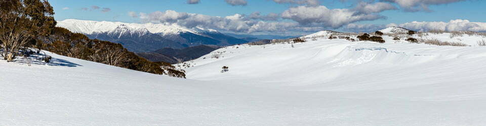
After checking out the views from Bundella Lookout, located adjacent to the carpark in the north-west corner of the park, we headed out along The Mullian Track through open woodlands towards The Pinnacle Lookout. The track to the lookout is short, open, easy and level. From the rocky point at the end, The Pinnacles Lookout, there are expansive views out over the vast rural landscape of the Liverpool Plains.

The Pinnacle Lookout
With rumours of a cave along the cliff-line below, we headed back along the main track searching for evidence of a route. Just off the rocky outcrop, to the north, we could discern a rough track so off we went. This route works its way out back around and under the lookout before heading away from it down a rocky spur. Along this section, you need to pay attention to clues as to which way to head, as it is not always obvious. Once down this rocky slope, we were starting to head more to the south and closely following the base of the cliff-line.
Below us, there was a steep, forest-covered scree slope and to our left the cliff. We followed this around a good distance only finding a couple of small overhangs in the cliff. After reaching a rougher section, I proceeded alone further along in search of the elusive cave, giving up as it became obvious I might have to venture quite a bit further and wasn’t willing to make everyone else wait too long for my return.
Our return followed the same route. Climbing back up the spur below the lookout had us questioning the details of the route a couple of times due to lack of obvious evidence across some of the rockier sections. After some great views from the lookout and a little bit of exploration, we were back to the main track at the lookout.
Rocky Creek
Max elevation: 1090 m
Total climbing: 135 m
Total descent: -136 m
Average speed: 3.83 km/h
Total time: 01:26:37
Upon reaching The Mullian Track we turned right and followed it to the south passing through some grassland and open woodland on our way to Rocky Creek. After crossing Rocky Creek we followed a rough track downstream to eventually find Rocky Creek Falls. Today it was a mere trickle and as there had been recent rain, the “falls” may be at it’s best immediately after heavy rain. We found a good viewpoint by traversing the steep northern creek-side out to a point near the cliff top where we could see the plunge pool at the base of the falls.
From the top of the falls, we returned northern-east, cross-country to intersect The Mullian Track and return to the car at Bundella Lookout.
NSW National Parks signage along this track also states
Bundella Lookout
Sit back and enjoy the view over the vast rural idyll of the Liverpool Plains and surrounding ranges. Picnic tables and wood barbecues are provided.
For a different view of the park, follow the walking track around to Pinnacle Lookout Walk.
Pinnacle Lookout Walk
Easy 1.6km return Grade 3 Time 45 minutes
Enjoy a stroll through woodlands before emerging onto an outcrop to expansive views. This lookout has rocky edges so please take extra care.
Bracken’s Hut
Back at Brackens Hut the camp oven was set up, the Eastern Grey Kangaroos were happily sharing their grassy, late afternoon grazing spot and later, after dark, we enjoyed the Milky Way draped over Brackens Hut.

Bracken’s Hut under the Milky Way
NSW National Parks signage at Brackens Hut states
Bracken’s Hut
Located on the edge of Norfolk Island Creek Swamp, this rustic accommodation sleeps up to 5 people and is a great base to discover the park’s trails. There are no kitchen facilities or electricity. Limited untreated water is available. Bookings can be made online.
Clickable icons on a world map which open the related trip report
A detailed, searchable trip list with links to reports, photo galleries and other content
![]()