
Saturday 17/10/2020 Belougery Split Rock
Warrumbungle National Park, NSW
Kamilaroi country
Participants: Stephen Davies (Photos), Sue Davies (Report), Trish Law, Dave Whitelaw
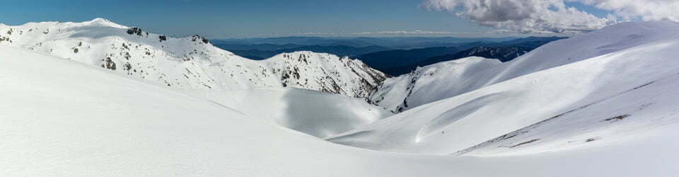
We set off at 8:00am on what was predicted to be a 30 degree day. The park signage at Split Rock Car Park recommends walking the circuit in an anti-clockwise direction, so that’s what we did. The trail headed south along the forested fire trail which gradually gained height and occasionally provided openings with great vistas of the bare, exposed rock faces of Belougery Split Rock and the adjacent Blackmans Mountain.
Max elevation: 805 m
Total climbing: 528 m
Total descent: -529 m
Average speed: 2.89 km/h
Total time: 03:07:49
Climbing steeply to the high point on Belougery Split Rock, mostly over solid rock, classic Warrumbungle views of The Breadknife and Mount Exmouth were clear and stunning as well as most of the other Warrumbungle peaks. By continuing past the summit rock cairn to the far end we also gained great views of the split between the volcanic plugs.

Mount Exmouth from Split Rock Track
During the descent we spent more time taking note of and enjoying sightings of the wildflowers, lizards and butterflies that were out. When we were not looking down towards the ground around us we noted with pleasure the continually changing perspectives stretching out before us off into the distant plains.
NSW National Parks recommend not to undertake the walk to the peak in wet weather for good reason. Unavoidable sections of very smooth polished rock, on the sidetrack to the summit especially, would be extremely slippery when wet.
This was a very enjoyable half day walk which we completed at a leisurely pace in three hours.
NSW National Parks description fo this walk
“Welcome to the Belougery Split Rock Walk. This steep 4.6km return trip takes about 2-3 hours to complete. During wet weather please do not climb to the top as the rocks become slippery.
Belougery Split Rock is a lava dome and was formed when viscous lava broke to the surface through the base rocks of Pilliga’s sandstone on which you stand. Viscous lava is very thick and does not flow easily, so when it reached the surface it built up around the vent and solidified.
From the eastern side of the walking track a good example of a scree slope can be seen. This is made up of broken material or ‘breccia’, formed as the pressure of new lava reaching the surface cracked the outer layer of solidified lava.
Wander around one of the park’s most distinctive lava domes. Fit, experienced walkers may wish to scramble up the summit.”
NSW National Parks signage along this track also states
“The word Warrumbungle has its roots in the local Aboriginal language. It is usually translated to ‘Crooked Mountains’. The mountains and the stories held within them have been drawing Aboriginal people from the surrounding plains for thousands of years.
In 2006, the park was added to the National Heritage List. The listing recognises not only the park’s extraordinary volcanic landforms which are unrivalled anywhere else in Australia, but its impressive biodiversity and importance as a refuge in inland south-east Australia.
The combination of the arid western plains, moist eastern slopes and elevation above the surrounding plains, provides habitat for a large variety of species. You are bound to see numerous animals including emus, red-necked wallabies and eastern grey kangaroos. Please report any sightings of koalas to the visitor centre to help us with our survey.
Warrumbungle National Park is Australia’s first International Dark Sky Park, making it the perfect spot for stargazing, amateur astronomy and camping under the starriest of skies.”
Burbie Canyon
Max elevation: 501 m
Total climbing: 72 m
Total descent: -74 m
Average speed: 4.36 km/h
Total time: 00:37:12
We enjoyed a short stroll along Burbie Canyon, there were abundant tadpoles in low levels of creek water, many wildflowers and bird life even in the heat of the day. There was a goanna carcass that appeared as if it had fallen out of a tree.

Burbie Canyon
NSW National Parks description fo this walk
Burbie Canyon
“Grade: easy to moderate Distance: 2 km return Time: 40 min Start: Burbie Canyon Car Park
Early morning and late afternoon are great times to do this walk. The air is cooler and birds are active, feeding amongst the trees and shrubs in the area. As you follow Burbie Creek you may find it dry. This is because this creek like many in the park is ephemeral. By this we mean that it only runs occasionally following large amounts of rain and then only for short periods.
Spring is the best time to visit the canyon, when the forest is ablaze with the colours of the many wildflowers. Early morning is great for bird watching.
During damper periods you may find frogs here such as the pobble bonk, which during dry periods are buried in the sand. When moisture seeps down to where they lie it signals them to surface to feed and breed. They must do this quickly and bury them selves again in the sand before it drys our or they will die.”
Tara Cave
Max elevation: 507 m
Total climbing: 135 m
Total descent: -135 m
Average speed: 3.71 km/h
Total time: 01:41:21
This short 2k walk to an aboriginal cave was rated as moderate. Given the 30 degree heat it was! We saw a plethora of wildflowers on the gradual uphill climb to the cave. The shallow cave was caged off but you can clearly see the grooves carved into the cave floor used for sharpening tools. The track on this walk is wide open and includes a number of raised boardwalk sections, especially at the cave end. Information signs are found along to track which explain a little about the areas history.

Grinding grooves at Tara Caves
Back just before the carpark we followed Wambelong Creek downstream where we found a secluded spot where we enjoyed a well deserved, refreshing dip before heading back to our campsite at Camp Wambelong.
NSW National Parks description for this walk
Tara Cave
“Grade: moderate Distance: 3.4 km return Time: 1.5 hr Start: Old Woolshed Picnic Area
Tara Cave is a fascinating rock shelter that was used by Aboriginal people for thousands of years. This deep cave has a large chamber at the rear and a tool-making site at the front. The cave can be seen from a viewing platform along the entrance.”
NSW National Parks signage along this track also states
“Warrumbungle Ranges are home to the peoples of the Kawambarai, Weilwan and Gamilaroi nations.
This land supported the Gamilaroi Language group who primarily occupied a large area, including the Namoi, Gwydir and Barwon Rivers. The local Aboriginal communities welcome you to Tara Cave a place of special significance. Rockshelter sites such as Tara were traditionally occupied and evidence of this such as axe grinding grooves and traditional Aboriginal stone tools is found within the cave.
The stone tools made and used by the local Aboriginal people was adapted to the locally available stone materials.
The most frequently used stone materials were quartz pebbles, which weathered out of the Pilliga Sandstone outcrops underlying the volcanics.
At the caves Many small stone artefacts were excavated. While the majority of the stone artefacts is made up of the waste produced from their manufacture some are clearly tools.
Among these most are general types used for simple cutting and scraping tasks but a small number are special function types such as backed and micro blades. These are thought to have been component parts in special composite tools such as lacerators known as Taap knives (pronounced tarp) and the fearsome death spear. The toolkits generally indicated a need for maximum flexibility in terms of usage coupled to a need for lightweight portability.”
Clickable icons on a world map which open the related trip report
A detailed, searchable trip list with links to reports, photo galleries and other content
![]()
You must be very fit as I couldn’t do a lot of the walks as too steep (64 yo with Health Issues)
I too am currently 64yo. I have been pretty lucky with my health to date but am actively walking, running etc most days and have been for decades to maintain some fitness.