
29/09/2019 – 4/10/2019 Guthega – Pounds Creek – Watsons Crags – Twynam West Ridge – Mount Anderson – Verandah Creek – Watsons Creek – Mount Anton – Tate East Ridge – Gills Knobs – Guthega Pondage – Mount Tate – Mann Bluff
Kosciuszko National Park, NSW
Ngarigo country
Distance: 55km Total Ascent: 3,880m Total Descent: 3,900m
Time: 26 hours Track Info
Participants: Damien Aggio (Leader), Stephen Davies (Photos, Report), Paul Davis, Murray Gibbs
Originally I had planned to arrive at the Pounds Creek campsite Damien had organised before anyone else, as I was going to connect my Charlotte Pass trip with his and avoid a trip home. I had 11 days of food and the rest of my gear packed and ready to go. However, my Mount Townsend day had consequences in the form of blisters on both heals from being clueless on how to adjust my new boots, I also ended up with a throat infection and lower back problem from consecutive long days. My better half also had suffered a bad cold for the last two weeks and had broken her fifth metacarpal (hand) so it was certainly best I drove home. Once everything settled enough I was heading back much later than first planned to connect with Damien’s now also finished trip. As it turned out I was still somewhat before par and had a low activity trip.
Day 1: Sunday 29/09/2019 Guthega – Pounds Creek
Max elevation: 1823 m
Total climbing: 465 m
Total descent: -294 m
Average speed: 3.32 km/h
Total time: 02:58:56
It was just about getting to camp today. After spending the last week trying to get over a triple whammy, blisters on both heels, throat infection and bad back I finally felt up to the attempt. Having packed my gear three weeks ago with the intention of commencing this trip on 21/09/2019 as extension an of that earlier trip, I was hoping I had everything!
Whilst about to leave Guthega carpark I ran into a couple of friends who were on their way out, needless to say an inevitable delay resulted as we did some catching up. Away at 3:00pm for a very slow and steady walk and ski up to Pounds Creek where I would join Damien, Murray and Paul who had arrived on Wednesday.

Illawong Hut
A pleasant calm warm afternoon had me carrying a very heavy pack partly on grass along the Illawong Track and 99% on snow after Illawong footbridge. The snow was firming up nicely in the late afternoon shade and as the light faded it cooled off. I reached camp just after the others had arrived back from their day out at 6:00pm.
Day 2: Monday 30/09/2019 Pounds Creek – Watsons Crags
Max elevation: 2191 m
Total climbing: 932 m
Total descent: -933 m
Average speed: 7.08 km/h
Total time: 06:15:14
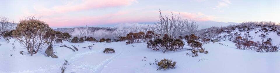
A bluebird day saw us head over towards Watsons Crags via Pounds Creek past Mount Anton before climbing up and over to the western side of Mount Twynam. A direct and well snow covered route, except for 2m of grass just after hitting the western side. The snow was an odd mix of rain eroded bumps of dust covered snow and large patches of fresher white snow, the combination resulting in a lot of inconsistencies being felt under the skis, especially whilst heading downhill.
We had many stops along the way as Damien seemed to struggle, at times, with simultaneously talking and walking, all least we gained a strong social aspect. Lunch was taken on rocks at the western most extremely of our excursion. The trip to this point is highly recommended as the views are outstanding.

Stephen, Paul and Murray on Watsons Crags
As I was feeling a bit lethargic today I headed back to our campsite after a single short downhill run to the south off Tennyson Knoll. I didn’t feel I missed out on to much as the afternoon snow was slow, heavy, bumpy and inconsistent. The rest of the group did a run down Twynam North Ridge before lingering on the ridge beside Mount Anton to watch the sunset before heading back to camp.
Day 3: Tuesday 1/10/2019 Pounds Creek – Twynam North Ridge
Max elevation: 2150 m
Total climbing: 554 m
Total descent: -554 m
Average speed: 7.18 km/h
Total time: 02:44:57
Paul opted to pack and leave after breakfast so as to not be home too late. Damien, Murray and myself left camp shortly after 8:00am heading along yesterday’s route. Our misson this morning was to find Murray’s camera which he’d lost somewhere on his descent of Twynam North Ridge yesterday. Luckily he located it a couple of feet from the lip of a cornice about half way down.
The run improved as we got lower as there was less of the fresh snow partial overlay and far fewer of the deep erosion bumps. At the botom we crossed the creek on snow before climbing up a creek valley and coming out at the southern side of Mount Anton. Here it was skins off again as we had the best run so far on the final leg coming off Mount Anton into camp. There is a lot to be said for consistent snow.

Damien climbing up “Mount Anton” Creek
Although only 11:00am it was time for Damien and Murray to finish packing and head out over Tate East Rigde. Later, they reported it to be a more interesting route than the standard Illawong footbridge route, although did involve a descent climb up and over Tate East Ridge as well as finding a upstream crossing (500m) on the creek before the ridge. It took them about an hour less than on the standard route (2 hours).
I opted for a very lazy campsite afternoon. Some time was spent on trying to get my heart rate monitoring watch charged, a very important aid for me in trying to restrict my heart rate due to a heart condition. Being unsuccessful I have ordered a new charging cradle and will have to take the rest of the trip, now solo, very easy. I also determined last night that my sleeping bag zipper will need replacement as it no longer works, even after a little repair during my last trip and when I got home. Lucky for me there are only mild nights forecast ahead.
Day 4: Wednesday 2/10/2019 Pounds Creek – Mount Anderson – Verandah Creek – Watsons Creek
Max elevation: 1928 m
Total climbing: 681 m
Total descent: -681 m
Average speed: 7.90 km/h
Total time: 06:10:13
A warmish sunny day with intermittent very cool breeze made getting correctly layered clothing very difficult. One minute warm it was warm and the next the breeze hits, an endless cycle throughout the day.
Without heart rate monitoring, I decided on a very slow, steady and easy day. Departing camp after 9:00am I first climbed Mount Anderson, ditching the skis near the summit before having a wander around amongst the granite boulders and taking in the views.

Boulders on Mount Anderson
From here I negotiated some exposed grassy saddles to get to the saddle to the west before skiing down to the north into the upper basin of Verandah Creek. A couple more runs between the saddle and creek were enjoyed before basking on a rock for lunch during a lull in the wind.
From here it was back up and over the saddle on softening spring snow for a run down the southern side towards Watsons Creek. These are two fantastic locations for spring skiing. It offers a good variety of aspects and inclines to cater for different skill levels, interests and sun impacts on snow conditions.
From the saddle I managed to pick my way back across the range on snow leads except for three or four very short sections of grass skiing.
Again the wind died right off after sunset. I had dinner out whilst taking night ski photos from the grassy ridge adjacent to camp.

Milky Way over Mount Anton
Day 5: Thursday 3/10/2019 Pounds Creek – Mount Anton – Tate East Ridge – Gills Knobs – Guthega Pondage – Mount Tate – Mann Bluff
Max elevation: 2051 m
Total climbing: 1005 m
Total descent: -1009 m
Average speed: 6.53 km/h
Total time: 06:03:47
Today offered the chance to explore routes across Tate East Ridge to the footbridge across Guthega River. Beforehand, I sort out a warm up run off Mount Anton before it softened too much, this proved to be the best run of my entire trip. My next target was to head down Pounds Creek but with the snow only being very local above and next to the creek I wasn’t prepared to risk breaking through and ending up in the water so initially I moved away from the creek before rejoining it further downstream. This section provided many open stretches of water between the snow bridges.Turning left up the next open tributary creek had me follow it north for 15 minutes before finding a safe crossing point.

Looking back up Pounds Creek
A slow 200m ascent initially following snow leads before removing skis and walking through the heath had me on top of Tate East Ridge south of Gills Knobs looking across Guthega River and Guthega. With skins now off a great run was now had in increasingly heavy snow down to Guthega River, initially on open hills before dodging between the trees on the steeper, lower section.
Having located the footbridge I was now happy to make a gradual ascent up to Mount Tate, passing two tents along the river and one further up. From Mount Tate I took a long traversing route back to camp via Mann Bluff. It had been a good, varied day out under blue skies with a light breeze. Again I spent the evening taking another day to night time-lapse under the light of a 2 day old new moon.
Day 6: Friday 4/10/2019 Pounds Creek – Tate East Ridge – Gills Knobs – Guthega Pondage – Guthega
Max elevation: 1934 m
Total climbing: 266 m
Total descent: -431 m
Average speed: 4.87 km/h
Total time: 02:36:53
With a good chance of some rain later today and long week-end hoards about to descend I decided to head out, despite having five days food supply remaining. The five nights camped at the same spot had taken there toll on the snow level, as evidenced by the amount of snow lost beyond the tent footprint. This despite several snow shovelling efforts to shore up the base around the tent.

Tent platform revelaling five days of snow melt
My route out morphed into a variant of yesterday’s. Basically sidling around without gaining or loosing much height until bumping into Tate East Ridge. One steep traverse section, did however, force some downhill traversing as the snow wouldn’t hold whilst traversing.
This time I crossed Tate East Ridge just to the north of Gills Knobs. It involved a couple of hundred metres of grass walking before rejoining the snow on the eastern side of Tate East Ridge. A short descent from the top had me on my tracks from yesterday which I loosely followed back down to Guthega River. A lot of caution was taken on the descent as the snow and pack were both very heavy, it was certainly not the time or place for weaving around or ducking under all those trees!
Across the footbridge there was still a short run of snow before the skis came off. The bank along Guthega Pondage has the occasional hint of a track but is quiet angled and demands your attention. In the last 100m before the dam I ran into Andrew Stanger (again!) who was heading out for the afternoon on a warm up trip before tackling Hannels Spur tomorrow. We had also crossed paths as he was heading out from his last trip from Mawsons Hut and I was heading in, what are the chances!
Clickable icons on a world map which open the related trip report
A detailed, searchable trip list with links to reports, photo galleries and other content
![]()
It was a magic following this trip. Drove me mad waiting for the photos to load. Gave up in the end. Nice they used different equipment.
Glad to see you enjoyed what you got to see but sorry to hear about the slow loading of the photos you experienced, they are however high quality and designed for computer screens. I know I might be a little old fashioned, but I see no point in carrying a Canon EOS 5D Mark IV on all my trips and uploading low quality (Phone screen sized) images. In fact I recommend using a modern large screen TV to view the panoramas to appreciate their resolution, they are amazing.
I use JPEGmini to minimise the file size of each photo to avoid losing quality and gain the fastest possible download speeds for the resolution I post. It would be interesting to hear about the technology you were using i.e. phone/tablet/computer 3G/4G/NBN Speed.
If you could get back to me I would greatly appreciate it.