
Day 2: Thursday 19/4/2018 Machhakhola – Dobhan
It Was A Blast!
Max elevation: 1893 m
Total climbing: 7495 m
Total descent: -7387 m
Average speed: 11.18 km/h
Total time: 08:33:08
Rule 1: Mules have right of way
Rule 2: Mountain side is safe side, mule side is suicide
Rule 3: Walk to the left side of Mani walls
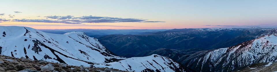
We left our tea house with Nepalese music playing and cute children running around. Often during today we needed to wait for multiple mule trains which appear to be the main means of transport for goods in the area. We climbed steadily up steps, thankfully in the shade as the day was quite warm. The air had cleared and we had glimpses of the mountains ahead. Hills are not considered mountains here unless they are over 6,000 metres. We then descended to the river, crossing a suspension bridge to our morning tea stop. Unfortunately, beside the river was the village rubbish dump. As with many developing countries waste management doesn’t appear to be a priority.
Day 2 on the Manaslu Circuit saw some rain and multiple waterfalls from one suspension bridge.
Our afternoon excitement started when we were stopped by the army due to blasting on our route ahead. The army apparently had nothing to do so they were directed to build the road. This route through Nepal to Tibet is apparently being financed by China. There were a few loud blasts and then we were permitted onto the trail but there was still substantial risk of rock fall and slippage. We tried to move through quickly while remaining 10 metres apart. We were glad to all survive the experience unscathed.

We had lunch at Tatapani which has a thermal hot water tap. Sarah, our group hairdresser offered hair washes and massage from the tap. This was a fantastic treat!
The final stage of the day involved walking along the river gorge. This was lovely although a storm blew through with some thunder, more excitement for the day!

Our accommodation for the night at Dobhan lay deep in the steep sided gorge. It lies at the confluence of the Shiar and Sarpu Kholas. We enjoyed vegetable curry and Mo Mos (dumplings) and a deep fried snickers for dessert.
Sarah reported that it was so warm she had slept naked for the last two nights. We looked forward to future updates.

Day 3: Friday 20/4/2018 Dobhan – Philim
A Taste Of Buddhism
Max elevation: 2283 m
Total climbing: 6457 m
Total descent: -5871 m
Average speed: 9.34 km/h
Total time: 09:40:25
We continued to walk up the lush gorge past small villages with children calling out “Namaste!” Again we had to give way to mule trains and were passed by locals carrying huge loads including day old chickens. We could see some fresh snow on the high peaks. We crossed suspension bridges high over the gorges. We stopped for a drink break and a tiny girl about two years old befriended us. Apparently, in these villages the children are left by themselves once they can walk. She wanted to touch us and obviously craved the human touch. The children are just gorgeous.

We continued to the entrance of the Manaslu Conservation Area and watched locals digging out and collecting river stone possibly for the road construction which is going to change these peoples lives forever.
We had a long lunch of vege omelette and vege curry. Masala tea is another daily favourite. The afternoon was described as an easy walk along the road but it ended up being quite long. We could notice a distinct difference in the villages in this Buddhist area, houses are made from attractive stone making for a neat appearance.
The rain started after lunch as seemed to be the weather pattern. We followed a scenic cliff side trail and then crossed another suspension bridge above a series of waterfalls, a really stunning spot.

The final section was a bit of a slog up a hill to the village of Philim. Hot showers, well one shower! Wifi was 250 rupees for unlimited access, a bit of a joke as it is so slow!! Potato and veg curry and Dahl baht for dinner.

Day 4: Saturday 21/4/2018 Philim – Lokpa – Chumling
Into The Tsum Valley or “I am not a guide”
Max elevation: 2491 m
Total climbing: 7858 m
Total descent: -7199 m
Average speed: 8.27 km/h
Total time: 09:49:07
Today started with another scenic gorge walk. The gorge was deep and the sides sheer where raptors soared around the cliff tops.
We watched a troop of monkeys feeding in the bamboo forest and on the other side of the trail there were large green conifers fresh with new spring growth. Flowering red rhododendrons provided bright colours on the trail.

Steve rigged up the solar panels with his tripod extended, supporting them above his head. He looked a sight! Locals laughed at him and even cows stared as he walked by.
We climbed steadily to reach our lunch spot at Lokpa where we enjoyed fried noodles and rice with veggies.
As we are now close to Tibet, the people here have a different appearance. They have darker skin with Mongolian features and rosy cheeks.
There were less animal trains on the the trail after lunch, and we had the feeling we were on the road less travelled. The Tsum region is home to about 4,000 people in 18 villages.
We met an Australian man returning from the Tsum Valley who was raving about the exquisite scenery. He said “your guide will show you where to go” indicating towards our own Ralston who is of Sri Lankan descent. He was often being mistaken for a Nepalese guide, much to his annoyance as he could not understand the locals talking to him in Nepali!
Our guides and porters set quite a slow pace with short five minute breaks every 30 to 40 minutes. This should help with our acclimatisation especially as we climb higher.

The afternoon involved a long ascent with glimpses of “real mountains” (over 6,000m). We then descended to cross another swing bridge and walked up our final hill for the day to the small village of Chumling. Another long day for us, starting at 7:00am and finishing at 5:00pm with a lunch over two hours.
For dinner we enjoyed fried potatoes with green veggies, vegetable paratha (fried thin bread) and vegetable mo mos. Delicious!

Day 5: Sunday 22/4/2018 Chumling – Chhokangparo
The Earth Moved!
Max elevation: 3055 m
Total climbing: 2883 m
Total descent: -2176 m
Average speed: 3.98 km/h
Total time: 06:03:43
We awoke to a clear morning with gorgeous views of the surrounding peaks from our vantage point high above the valley. We crossed a suspension bridge and then headed on a “Nepali flat” path through lush green forest through to a simple monastery. We soon learned that “Nepali flat” means anything but! The weather was perfect but we still were a little warm walking.
From the village we walked along the track high above the surging waters of the clear river. We could see some very high remote settlements and wondered what life would be like in such a remote location. A small girl and even tinier boy followed me for a while along the track, they seemed to want to stay close behind but as soon as they reached their destination they were off.
Walking through a small village in the Tsum Valley (Day 5 on the “Manaslu Circuit-Tsum Valley” trek)
We saw a snake which was light green coloured and apparently venomous. It was a bit disturbed by our presence and slithered across the path. We came across a group of black faced monkeys with heads fringed by white fur in the trees. They quickly scurried away when they saw us approach.
Along this section we enjoyed ever more impressive views of Ganash Himal. The air was clear and the views of the peaks were stunning.

We had morning tea in a tent where we bought bala (woven bracelets). We were missing our daughter Beth today as it was her 25th birthday and we had hoped we could at least send her a message. The Tsum Valley however is very isolated and we are now beyond mains electricity. The locals are currently awaiting the completion of a hydro electric power station. Part of the deal involves one person from every house helping with some aspects of the construction.
We saw a group of workers doing track maintenance. One brave soul was working off the edge of a drop off using a “harness”, a bit of material tied around his waist and attached to a stake.
After about three hours walking we reached an avalanche slope which had injured a walker with a rockfall the previous day. We were advised to approach the area with caution. Two of our porters had already passed the section with their loads by the time we got there. They and our guides were constantly on the lookout for rockfalls and called out instructions to us as we crossed. There were close calls for Emily and Wendy with rocks falling about two metres away from both of them. The guides and porters did a fabulous job of getting us across safely. It certainly got the blood pumping!

Pleased to still be alive, we continued on the long climb to the upper Tsum Valley. The stone houses with their blue corrugated roofs and mani walls with Tibetan mantras inscribed were a common feature of the villages.
We arrived in Chhokangparo in time to have a cold water shower, wash some clothes and relax for the afternoon. Our late lunch consisted of our usual fried noodles and fried rice. It was quite a luxury to have a free afternoon and to be able to have a cold water wash while it was still warm enough.
Day 1: Wednesday 18/4/2018 Soti Khola – Machhakhola
The Sky Is Falling
Max elevation: 947 m
Total climbing: 3453 m
Total descent: -3277 m
Average speed: 5.58 km/h
Total time: 06:35:48
We had a fantastic breakfast of potato curry, fried bread and masala tea. We said our goodbyes to our wonderful host family and took lots of photos. We hopped on the bus at 7:00am not knowing what to expect for the day or where we would end up. Our aim was to drive to the start of the walk at Soti Khola but it was totally dependent on the road conditions and how far we could progress.

To our surprise we made quite good time despite the usual forward and back progress, as we had to reverse frequently to give way to buses and trucks travelling in the other direction. After about three and half hours we were surprised to arrive at Soti Khola. We were back on track!!
After coffee the porters prepared their loads and we were finally on our way. We were really happy as yesterday it seemed doubtful that we would be walking at all today.
The trail climbed gradually through forests, past terraced ridges and several waterfalls. There were locals carrying loads and donkey trains. There were monkeys swinging between branches of the trees beside the trail.

After lunch we descended into a very deep glacial valley. This was a detour from the usual route due to road construction. We felt very insignificant with the sides of the valley towering above us. We had several river crossings including one where a front end loader was working and dropping rocks and debris from above us. Our guide Prabin signalled for the driver to stop while we were crossing. He stopped for a short while but became impatient and recommenced dropping rocks over the edge even though walkers were below him and were at risk of injury or death. He again stopped momentarily while everyone scrambled to get out of the way.
We continued along the valley until we reached the village of Machhakhola and our tea house for the evening.
Day 2: Thursday 19/4/2018 Machhakhola – Dobhan
It Was A Blast!
Max elevation: 1893 m
Total climbing: 7495 m
Total descent: -7387 m
Average speed: 11.18 km/h
Total time: 08:33:08
Rule 1: Mules have right of way
Rule 2: Mountain side is safe side, mule side is suicide
Rule 3: Walk to the left side of Mani walls
We left our tea house with Nepalese music playing and cute children running around. Often during today we needed to wait for multiple mule trains which appear to be the main means of transport for goods in the area. We climbed steadily up steps, thankfully in the shade as the day was quite warm. The air had cleared and we had glimpses of the mountains ahead. Hills are not considered mountains here unless they are over 6,000 metres. We then descended to the river, crossing a suspension bridge to our morning tea stop. Unfortunately, beside the river was the village rubbish dump. As with many developing countries waste management doesn’t appear to be a priority.
Day 2 on the Manaslu Circuit saw some rain and multiple waterfalls from one suspension bridge.
Our afternoon excitement started when we were stopped by the army due to blasting on our route ahead. The army apparently had nothing to do so they were directed to build the road. This route through Nepal to Tibet is apparently being financed by China. There were a few loud blasts and then we were permitted onto the trail but there was still substantial risk of rock fall and slippage. We tried to move through quickly while remaining 10 metres apart. We were glad to all survive the experience unscathed.
We had lunch at Tatapani which has a thermal hot water tap. Sarah, our group hairdresser offered hair washes and massage from the tap. This was a fantastic treat!
The final stage of the day involved walking along the river gorge. This was lovely although a storm blew through with some thunder, more excitement for the day!
Our accommodation for the night at Dobhan lay deep in the steep sided gorge. It lies at the confluence of the Shiar and Sarpu Kholas. We enjoyed vegetable curry and Mo Mos (dumplings) and a deep fried snickers for dessert.
Sarah reported that it was so warm she had slept naked for the last two nights. We looked forward to future updates.
Day 3: Friday 20/4/2018 Dobhan – Philim
A Taste Of Buddhism
Max elevation: 2283 m
Total climbing: 6457 m
Total descent: -5871 m
Average speed: 9.34 km/h
Total time: 09:40:25
We continued to walk up the lush gorge past small villages with children calling out “Namaste!” Again we had to give way to mule trains and were passed by locals carrying huge loads including day old chickens. We could see some fresh snow on the high peaks. We crossed suspension bridges high over the gorges. We stopped for a drink break and a tiny girl about two years old befriended us. Apparently, in these villages the children are left by themselves once they can walk. She wanted to touch us and obviously craved the human touch. The children are just gorgeous.
We continued to the entrance of the Manaslu Conservation Area and watched locals digging out and collecting river stone possibly for the road construction which is going to change these peoples lives forever.
We had a long lunch of vege omelette and vege curry. Masala tea is another daily favourite. The afternoon was described as an easy walk along the road but it ended up being quite long. We could notice a distinct difference in the villages in this Buddhist area, houses are made from attractive stone making for a neat appearance.
The rain started after lunch as seemed to be the weather pattern. We followed a scenic cliff side trail and then crossed another suspension bridge above a series of waterfalls, a really stunning spot.
The final section was a bit of a slog up a hill to the village of Philim. Hot showers, well one shower! Wifi was 250 rupees for unlimited access, a bit of a joke as it is so slow!! Potato and veg curry and Dahl baht for dinner.
Day 4: Saturday 21/4/2018 Philim – Lokpa – Chumling
Into The Tsum Valley or “I am not a guide”
Max elevation: 2491 m
Total climbing: 7858 m
Total descent: -7199 m
Average speed: 8.27 km/h
Total time: 09:49:07
Today started with another scenic gorge walk. The gorge was deep and the sides sheer where raptors soared around the cliff tops.
We watched a troop of monkeys feeding in the bamboo forest and on the other side of the trail there were large green conifers fresh with new spring growth. Flowering red rhododendrons provided bright colours on the trail.
Steve rigged up the solar panels with his tripod extended, supporting them above his head. He looked a sight! Locals laughed at him and even cows stared as he walked by.
We climbed steadily to reach our lunch spot at Lokpa where we enjoyed fried noodles and rice with veggies.
As we are now close to Tibet, the people here have a different appearance. They have darker skin with Mongolian features and rosy cheeks.
There were less animal trains on the the trail after lunch, and we had the feeling we were on the road less travelled. The Tsum region is home to about 4,000 people in 18 villages.
We met an Australian man returning from the Tsum Valley who was raving about the exquisite scenery. He said “your guide will show you where to go” indicating towards our own Ralston who is of Sri Lankan descent. He was often being mistaken for a Nepalese guide, much to his annoyance as he could not understand the locals talking to him in Nepali!
Our guides and porters set quite a slow pace with short five minute breaks every 30 to 40 minutes. This should help with our acclimatisation especially as we climb higher.
The afternoon involved a long ascent with glimpses of “real mountains” (over 6,000m). We then descended to cross another swing bridge and walked up our final hill for the day to the small village of Chumling. Another long day for us, starting at 7:00am and finishing at 5:00pm with a lunch over two hours.
For dinner we enjoyed fried potatoes with green veggies, vegetable paratha (fried thin bread) and vegetable mo mos. Delicious!
Day 5: Sunday 22/4/2018 Chumling – Chhokangparo
The Earth Moved!
Max elevation: 3055 m
Total climbing: 2883 m
Total descent: -2176 m
Average speed: 3.98 km/h
Total time: 06:03:43
We awoke to a clear morning with gorgeous views of the surrounding peaks from our vantage point high above the valley. We crossed a suspension bridge and then headed on a “Nepali flat” path through lush green forest through to a simple monastery. We soon learned that “Nepali flat” means anything but! The weather was perfect but we still were a little warm walking.
From the village we walked along the track high above the surging waters of the clear river. We could see some very high remote settlements and wondered what life would be like in such a remote location. A small girl and even tinier boy followed me for a while along the track, they seemed to want to stay close behind but as soon as they reached their destination they were off.
Walking through a small village in the Tsum Valley (Day 5 on the “Manaslu Circuit-Tsum Valley” trek)
We saw a snake which was light green coloured and apparently venomous. It was a bit disturbed by our presence and slithered across the path. We came across a group of black faced monkeys with heads fringed by white fur in the trees. They quickly scurried away when they saw us approach.
Along this section we enjoyed ever more impressive views of Ganash Himal. The air was clear and the views of the peaks were stunning.
We had morning tea in a tent where we bought bala (woven bracelets). We were missing our daughter Beth today as it was her 25th birthday and we had hoped we could at least send her a message. The Tsum Valley however is very isolated and we are now beyond mains electricity. The locals are currently awaiting the completion of a hydro electric power station. Part of the deal involves one person from every house helping with some aspects of the construction.
We saw a group of workers doing track maintenance. One brave soul was working off the edge of a drop off using a “harness”, a bit of material tied around his waist and attached to a stake.
After about three hours walking we reached an avalanche slope which had injured a walker with a rockfall the previous day. We were advised to approach the area with caution. Two of our porters had already passed the section with their loads by the time we got there. They and our guides were constantly on the lookout for rockfalls and called out instructions to us as we crossed. There were close calls for Emily and Wendy with rocks falling about two metres away from both of them. The guides and porters did a fabulous job of getting us across safely. It certainly got the blood pumping!
Pleased to still be alive, we continued on the long climb to the upper Tsum Valley. The stone houses with their blue corrugated roofs and mani walls with Tibetan mantras inscribed were a common feature of the villages.
We arrived in Chhokangparo in time to have a cold water shower, wash some clothes and relax for the afternoon. Our late lunch consisted of our usual fried noodles and fried rice. It was quite a luxury to have a free afternoon and to be able to have a cold water wash while it was still warm enough.
Day 6: Monday 23/4/2018 Chhokangparo – Nile (pronounced Nylae)
Deep Into The Tsum Valley
Max elevation: 4164 m
Total climbing: 2673 m
Total descent: -2402 m
Average speed: 6.42 km/h
Total time: 07:22:42
We were off to an early start again on a less challenging route up the valley. The weather was stunning and we were surrounded by grandeur in all directions. Ganesh IV was particularly impressive. We followed the river along the deep and wide glacial valley acknowledging the locals with the Sherpa greeting of “Taishi Delek”. We passed several small villages that certainly make good use of the local materials, the stone houses appear to be assembled like a jigsaw puzzle – no mortar is used.
We stopped at a small farmhouse before taking a short detour to Milarepa’s cave who was a Buddhist disciple who spent years meditating there. On the walk up two small children followed us. Even our guide, who speaks multiple languages and dialects, could not communicate with them. The children’s hair in this area looks very oily and the parents apparently rub sunflower oil into their scalps from a young age, especially around the fontanelles. They were happy to pose for photos but they actually wanted a balloon or chocolate. Steve was probably responsible for this trend as in 1985 on his last trip to Nepal he was handing out balloons. Further up the valley some tiny children yelled out “give me some chocolate” in English.

At Milarepa’s cave we were lucky our guide had the key so we could look through the two chapels and caves situated high above the river. The views were stunning and it was a very peaceful place.
We then returned to the farmhouse where they were kind enough to prepare noodle soup with egg for our lunch. Somehow another group of five seems to have been tacked onto our group and is making full use of our guides expertise without paying for it!
From lunch it was an easy flat walk further down the valley which seemed to become more barren as we went along. The stone Mani walls (always walk to the left) are very long in this area and you just wonder about the history of all the inscriptions each stone. Stone walls and fences were frequent.
We saw signs spray painted on rocks with the hammer and sickle and what appeared to be swastika symbols and these were apparently advertising for a political party before the last election. These remote areas are visited during an election so everyone has the opportunity to vote.
In one of the villages we were lucky to meet the keeper of the keys to get inside a small monastery with a huge prayer wheel which you are meant to complete one, three or five times. This area has an unique Buddhist philosophy of which there are many.

Some villages in this area up to 30 years ago practiced sky burials where they took the body to a high place and chopped it up for the vultures to feed on. I guess it was a dying practice.
We soon reached our destination as the weather became colder and we had a masala tea before settling into our two single bed room for the night.The boys prepared a chocolate cake for Wendy’s birthday. “Wendy Happy birthday” was written on it. It was cold overnight.

Day 7: Tuesday 24/4/2018 Nile – Chhokangparo
In The Shadows Of Towering Giants
Max elevation: 3648 m
Total climbing: 1691 m
Total descent: -1972 m
Average speed: 4.41 km/h
Total time: 10:37:07
Our first destination today was the Mu Gompa, a 1,200 year old monastery at the last permanent settlement in the valley. We felt very insignificant surrounded by the towering peaks. From Mu Gompa we could see the peaks that border Tibet. The views of Ganesh Himal were stunning and the setting very peaceful.

We headed back down to Nile for lunch. The wind had increased along with the chill factor.
Sarah and Emily were offered Rakese (a local spirit made from grains) from a llama in a monastery which was first built somewhere between 1,800 and 8,000 years ago (the age of it kept changing, as more Rakese was drunk!). There was a group of men inside who had probably been drinking there all day.
Steve wasn’t feeling too well and was off his food. After attempting to eat some lunch he had his first spew in over 30 years, possibly when his last time in Nepal. The rest of us polished off his pancake which was delicious!
We headed down the valley on the opposite side of the river to visit the Rachen Gompa Buddhist Nunnery. The girls enter when just five years old and need to decide by age 10 whether they want to stay permanently. They chant and pray and learn about Buddhism. It seems like a harsh life but compared to the dirt poor existence in some of the villages it would likely be considered a better option. The small Buddhist disco entertainment centre complete with electronic candles, spinning prayer wheels and a USB port had us wondering.

It was a full day of walking arriving at our accommodation in Chhokangparo 4at 6:00pm. Steve went to bed early without dinner in the hope of recovering quickly.

Day 8: Wednesday 25/4/2018 Chhokangparo – Lokpa
Leaving The Valley Of Stones
Max elevation: 3054 m
Total climbing: 5143 m
Total descent: -6268 m
Average speed: 7.81 km/h
Total time: 09:29:19
We started the day with our usual 6:30am breakfast and left soon after at 7:00am. Our first task was to safely pass the avalanche path, luckily this early in the day there were not many rocks falling.
We stopped briefly at Gho but there was no water available. The toilet was in the same clogged state as when we passed by days ago on the way up the Tsum Valley. Very gross!
The girls were powering on but the boys were a bit fragile today and lacking in energy. The gorge was sheer sided and the air hazy providing a different atmosphere and views. Tall conifers were growing on the steep sided cliffs and glimpses of Ganesh Himal 1 could be seen down the valley.

Along the trail we found streaks of blood, making it look like a massacre site. We then saw long hoofed legs sticking out as we came across across a cow being skinned. The man flung the skin in the air as the bloody carcass sat in the hot sun. These Buddhists cannot kill anything but are permitted to eat the meat of an animal that has already died.
Crossing an active rock fall slope in the Tsum Valley
We crossed several metal suspension bridges high above the gorge. There was evidence of the old bridge down in the gully and we were glad we were on the new bridge.
We climbed up to Chumling for lunch where we enjoyed parathas. From lunch it was still close to four hours to Lokpa, our destination for the day. It was again Nepali flat – up and down repeatedly. We were all pleased to arrive at our accommodation at around 5:00pm and have a very welcome cold water wash.

Day 9: Thursday 26/4/2018 Lokpa – Deng
Onto The Manaslu Circuit
Max elevation: 2127 m
Total climbing: 8169 m
Total descent: -8193 m
Average speed: 12.63 km/h
Total time: 07:34:07
Today was a rest day (relatively) after two long days of walking. We followed the trail down to the river and crossed the “New Bridge” suspension bridge and were back onto the Manaslu Circuit. There were large rocks embedded in this suspension bridge, from rockfalls. It was sad to have to say goodbye to the Tsum Valley but also exciting to begin walking over some new territory.
We passed several mule trains. Some mules wore regal looking head and tail dress and apparently these are the “mule of the day” -the best behaved. Those who don’t behave have rocks thrown at them by their keepers.

We climbed gradually along the gorge through lush bamboo forest. The sky was quite hazy again today, the views being much less clear than we enjoyed for most of the Tsum Valley.

We had a long lunch at Pewa of fried Mo Mos and fried vege noodle with egg. It was a short walk (75 minutes) to our accommodation at Deng. A hot bucket shower proved to be most welcome.
After dinner we had celebrations for Emily’s birthday. A snickers cake being made by our guides and porters. It was it was delicious and happily shared by everyone in the tea house. After dinner we played cards for a while. Surprisingly the wifi was turned on for ten minutes while the staff madly checked their phones before being promptly turned off again. We had earlier been told the wifi hadn’t been worked for three days.

Day 10: Friday 27/4/2018 Deng (Dyang) – Namrung
One Big Happy Family
Max elevation: 2703 m
Total climbing: 6061 m
Total descent: -5342 m
Average speed: 6.09 km/h
Total time: 09:39:29
We enjoyed some amazing scenery today, crossing six suspension bridges and walking alongside impressive canyons, waterfalls and gorges. There were steep sided cliffs rising above swirling torrents and water stained rocks.

We enjoyed lunch at Ghap before a long tiring climb through gorgeous rainforest of conifers and junipers. A black faced monkey was eating in the trees and Steve managed to get some great photos. We also saw geckos, yak, tahr, squirrels and mountain goats.

A young man from the other group asked if we were a family. Just Steve and I and our band of adult kids.
Sarah gave two young boys a pencil each and they had no idea what to do with them. It was so interesting watching them use the pencils as weapons and to annoy each other. We just wanted to clean them up with a wet wipe.

After a long uphill slog we were glad to arrive to the flushing toilets at Namrung. They were quite cold to sit on though and by this stage we were used to the squat toilets!

Day 11: Saturday 28/4/2018 Namrung – Lho
A Surprise Cricket Match
Max elevation: 3185 m
Total climbing: 2167 m
Total descent: -1605 m
Average speed: 4.30 km/h
Total time: 04:24:51
We awoke to mist high around the Manaslu peaks which thankfully quickly cleared revealing brilliant views of the mighty mountain and surrounding peaks.

It was a gradual uphill climb today past villages which seemed mainly deserted. There was evidence of what appeared to be damage to the stone houses from the April 2015 earthquake.
We passed a mix of forest and barley fields and impressive chortens (rock monuments). The carefully constructed stone houses with bright blue roofs are a feature of the area.
It was great to arrive early at our destination in time for lunch. Here we enjoyed the warmth of the sun and savoured mo mos with fried potatoes and vegetables.
Our afternoon acclimatisation walk
Max elevation: 3323 m
Total climbing: 336 m
Total descent: -344 m
Average speed: 4.13 km/h
Total time: 01:22:34
After a rest we headed off for an afternoon stroll to the Ribung Monastery high on the hill above Lho. It was built 400 years ago, the interior was intricate and impressive. Here we met a 13 year old monk who had been living there for four years.

On the walk down we saw the young monks playing soccer with a flat ball. Our porters joined in the game. Alongside was a another group playing cricket. Being a cricket expert, this made Ralston’s day as he joined in. It was great seeing the young monks enjoying themselves. When they left the monks said “see you next time”.
Dinner was vege curry, vege spring roll and apple pie.
Day 12: Sunday 29/4/2918 Lho – Sama Gaon
A Brush With Holiness
Max elevation: 3606 m
Total climbing: 1380 m
Total descent: -1055 m
Average speed: 3.76 km/h
Total time: 05:16:25
We awoke to wonderful views of the sunrise light on Manaslu. We climbed back up to the monastery to link up with the trail.
Day 12 on the Manaslu Circuit, a pause due to local traffic!
The stunning views continued and we stopped for a short detour to hike up to a monastery set amongst the huge peaks of the Manaslu area. There was only one monk there but he was very friendly and invited us in and offered us yak tea. We politely declined as Emily had tried yak tea; the combination of melted yak butter and salt is an acquired taste, no doubt! He chanted and read from the sacred scrolls. It was the perfect setting and such a peaceful place.

Back on the main trail we saw the Llama from Sama Gaon being carried by four men on a thu (carriage chair). He was apparently 103 years old. Unfortunately, we were not permitted to photograph him and we respected that request.
We soon reached a wide valley and onto Sama past the “basic” spacious school which was rebuilt post the 2015 earthquake. It was great to see aid being directed in practical assistance to the locals. It was a fascinating village with a massive Mani wall and endless stone buildings.
We reached our accommodation for lunch and relaxed in the afternoon as the mist descended and the temperature dropped.
I didn’t feel too good in the afternoon, similar to how Emily and Sarah had felt in previous days. It was hard to keep awake until the 6:30pm dinner time.

We have some pranksters in the group especially Ralston who tries to pinch Rossan’s gear while he isn’t looking. Prabin also placed a large rock in Rossan’s pack which he carried all day without knowing. There is lots of good humoured teasing going on in our group.
Day 13: Monday 30/4/2017 Sama Gaon – Pungyen Gompa and return
Who Moved The Monastery?
Max elevation: 4083 m
Total climbing: 2159 m
Total descent: -2158 m
Average speed: 3.93 km/h
Total time: 07:03:38
Today was our “rest” and acclimatisation day so we decided to head off early to the Pungyen Gompa Monastery for the views and acclimatisation climb. We left for our walk at 6:00am and it was too early for breakfast but we were able to have a hot drink.
The weather was not looking too promising as the mist descended soon after we reached the trailhead. The climb was tough and we were all breathing heavily as we climbed the steep track beside a raging glacial river. We were really happy as the mist began to break up and we started getting a glimpse of the stunning scenery. We saw tahr on the steep slopes and “mountain rabbits” which looked like marmots running around close to the cliffs.

We stopped to enjoy the scenery and take lots of photos at a high point and we felt very lucky to be in this place, surrounded by giants of mountains. The monastery was a fair bit further that we had anticipated and we were wondering who moved it.

We continued up the flatter trail to reach the deserted monastery continuing to take photos as the yaks grazed freely at the high altitude. We were all happy to reach the elevation of 4014m with minimal effects.

On the return trail Ravi rushed past everyone to turn on Nepali music and made us dance at 3,937m. Everyone joined in and it was a fantastic moment.
Day 12 on the Manaslu Circuit, altitude training or spontaneous dancing?
We had some light hail and rain on the way back down but was were all very happy and felt it may be our best day of the trip yet.
We continued on the descent meeting many free roaming yaks and their babies. Parwin did a great job of herding them away. Back on the main trail we met a woman with a basket heading up on the trail and she was asking about the yak babies. She was apparently headed up to capture at least one and we felt that she was a brave soul.
We returned to our accommodation for a late lunch and for an afternoon of relaxation. It’s not often you walk nearly 20km before breakfast at altitude but it was definitely worth it.

Day 14: Tuesday 1/5/2018 Sama Gaon – Samdo
A Walk Amongst The Towering Giants
Max elevation: 3838 m
Total climbing: 907 m
Total descent: -598 m
Average speed: 3.53 km/h
Total time: 05:16:48
We awoke to a stunning morning, crisp and clear. We headed up to the glacial lake for some amazing views. There were icebergs in the lake and we heard cracking and avalanches from the Manaslu glacier above the lake. We spent quite a bit of time relaxing in the warm sun and taking numerous photos.

Day 14 on the Manaslu Circuit, Prabin and Rosan enjoy a game on the shores of Birendra Tal beneath Manaslu Glacier.
We then headed back on the main trail which followed the valley and the river to Samdo. We felt dwarfed by these “real mountains” the views were stunning against the clear blue sky.
We arrived at Samdo in time for lunch at our very basic accommodation. As Prabin said “these people don’t know how to build anything”. There was a sloping concrete floor in the bathroom and the concrete steps had no bannister. This was our most primitive accommodation yet.
Our afternoon acclimatisation walk
Max elevation: 4064 m
Total climbing: 545 m
Total descent: -535 m
Average speed: 3.09 km/h
Total time: 02:24:27

In the afternoon we did an acclimatisation walk above the village. It was a steep track and the views were impressive. We climbed to 4057m and rested before descending back to the village. It was freezing cold and our rooms were like concrete cells.
As the Nepali saying goes
“Dahl Baht power
24 hours
No need for toilet or shower”

Day 15: Wednesday 2/5/2019 Samdo – Dharamsala
Higher And Higher
Max elevation: 4478 m
Total climbing: 1387 m
Total descent: -747 m
Average speed: 3.25 km/h
Total time: 04:28:51
We left Samdo under brilliant clear skies. The views were breathtaking. We gained increasingly better views of the position of Samdo deep in the valley, framed by towering peaks. It was a gradual uphill climb and we stopped frequently to help with the increasing altitude and to soak in the awesome views. We finally got to see blue sheep which are actually tan in colour.

Every turn revealed even better views and we gradually ascended the valley towards the Larkya Glacier. We arrived at the temporary settlement of Dharamsala (4,460m) in time for lunch. Our accommodation this time was in tents and very simple. The toilet was apparently in a dreadful state but there were a few long drop toilets which offered the best option. It was quite ironic that in the “dining room” which had a floor of rocks and dirt there were plastic flowers in vases on the table.
Our afternoon acclimatisation walk
Max elevation: 4650 m
Total climbing: 488 m
Total descent: -493 m
Average speed: 3.40 km/h
Total time: 01:44:40
We had a quick nap before heading off on our afternoon acclimatisation walk which was a struggle initially. I’m sure it was good for us. We climbed the hill behind the camp for views towards our destination tomorrow. As the cloud had come in, the scene looked like a black and white photo with the glacier and what seemed like endless rocky moraine. We had climbed another 182 vertical metres and we were all puffing and panting.

We had an early dinner and went to bed after 7:00pm to prepared for our big day tomorrow.

Day 16: Thursday 3/5/2018 Dharamsala – Larkya La – Bimthang
Over The Pass But Where Are The Views?
Max elevation: 5147 m
Total climbing: 1252 m
Total descent: -2011 m
Average speed: 2.85 km/h
Total time: 09:35:04
We awoke at 3:00am to prepare for a 4:00am departure. It was cold, dark and fairly clear when we headed off. We were just putting one foot in front of the other as we walked along the barren and frosty trail. We climbed along the northern moraine of the Larke Glacier. I wore five layers on my top half including a down jacket and three layers on the bottom and I was quite comfortable. After about an hour there was enough light to be able to see the emerging scenery. Dawn light revealed the pink tinged stunning mountains that surrounded us.

The trail was thankfully a gradual climb but as we ascended the clouds and mist descended. It was again like a black and white painting. Walking at at high altitude is a bit like walking through molasses and trying to breath as if you were running at high speed. You just can’t seem to get oxygen fast enough. And your quads burn. Up and up we ascended until we finally reached the Larkya La pass complete with prayer flags at 5106m. It was a great moment and we were so glad everyone had made it safely.

Then for the long descent! As soon as we left the pass the snow started. We put our crampons on. Ravi and Parwin (our porters) shared a pair of crampons. Ka Ka didn’t have any despite the all carrying loads of up to 30kg. In a steep section Ravi went down backwards on his hands and knees. These guys are just amazing, always smiling and looking out for the group.
The descent was long and devoid of views due to the low mist which made it seem very long. The snow turned to rain and we got soaked. We were so pleased when we saw the village of Bimthang and we arrived at our accommodation at 1:50pm for a well deserved relaxing afternoon.
Pravin told us at the briefing that night that we didn’t need to worry about drinking water anymore, just whiskey!

Day 17: Friday 4/5/2018 Bimthamg – Dharapani
Rhododendron Heaven
Max elevation: 3720 m
Total climbing: 3274 m
Total descent: -5052 m
Average speed: 5.10 km/h
Total time: 09:38:36
We awoke to a crystal clear morning which was so welcome after yesterday’s rain. We were surprised to see pristine mountains around us. Bimthang has been rebuilt following the 2015 earthquake and the buildings are painted brightly. The village had an incredible backdrop which looked like a gigantic painting of mountain scenery.

We descended and then crossed glacial moraine with pristine views of Manaslu. We then descended saying goodbye to Manaslu and entered the Annapurna Conservation Area. We entered a gorgeous rhododendron forest with red, pink and white trees.
Day 17 on the Manaslu Circuit, a rhododendron forest, donkey train delivery and all our party.
We then followed the milky glacial river Dudh Khola with its red coloured rocks.
We saw a yak herder who had a tough time with his group of yaks including the young ones. He was moving them to higher ground and they were going in every direction and not wanting to move!

After lunch we continued our descent, down until until we reached our destination Dharapani. About 30km and 2,000m descent making it a very long day. Our hotel was incredible with an ensuite, cold shower only and a western toilet! Luxury!

Day 18: Saturday 5/5/2018 Dharapani – Syange
Onto The Annapurna Circuit
Max elevation: 2159 m
Total climbing: 7997 m
Total descent: -8778 m
Average speed: 9.69 km/h
Total time: 09:23:08
As we left our luxury accommodation, which if it was in Australia would be about a two star hotel, we started walking along the road. The mule trains of the Tsum Valley were replaced by jeeps and motorbikes which was a shock. We were back in civilisation!

As we were walking through the village a group of Nepalese army soldiers were walking towards us, all of them bearing rifles. My first thought was “Steve please don’t take a photo”. Of course he did.
After a while we were pleased to leave the road, crossing the river on our way to Tal. We stopped for an early lunch in Tal for their local specialty of potato pumpkin and bean curry with corn bread. While we waited we played cards. The meals was absolutely delicious and one of our best yet.
On the Annapurna circuit you don’t need to use a guide and there were few porters so when trekkers saw Kaka with his load they just stared. One young woman said “how does he do that!” We were walking in the opposite direction to most of the walkers who were likely just starting their trek. Steve told them they were going the wrong way, just to stir them up.
We returned to the trail following the river gorge. We returned to the roads and had to compete with jeeps and motorbikes. It was a steamy afternoon and we were very pleased to arrive at our accommodation just before 5:00pm and just afterwards the heavens opened. We were finished and very tired! It was a great night of partying, thank you’s and reminiscing. And of course dancing!
Day 18 on the Manaslu Circuit, we all articulate our trip highlights and celebrate the completion of a successful trek.
Day 19: Sunday 5/5/2018 Syange – Kathmandu
Day 19 on the Manaslu Circuit, our jeep drive out from Syange to Besisahar before transferring to a bus for the return to Kathmandu.
The stats:
Starting elevation 710m
End point elevation 760m
Highest point 5160m
One lukewarm shower, two bucket showers, a few cold washes, one cake of soap and a few baby wipes here and there
Total kilometres 353km
Things we will miss:
Pristine alpine scenery
Great vegetarian food
Namaste, Tashi delek
The wonderful carefree mud encrusted children
The beautiful Nepalese people, so happy despite their poverty and meagre living conditions
And our wonderful team lead guide Prabin, strong, caring and always smiling. He set the tone of the trip. He was always ready to help us and was very protective of our welfare.
Hilarious and cheeky Rossan, our assistant guide. Rossan was always calling me “Shuue” More people should follow his approach to life, seeing humour in everything!
Our porters, the wonderful gentle KaKa, kind Parwin and cool Ravi who was always ready to dance.
Our fellow travellers; easy going Emily, determined and smiling Wendy, gadget man Steve, prankster Ralston and the wonderful bubbly Sarah who put together the trip and was willing to accept a few oldies into the group.
It will be a trip we will never forget.
Clickable icons on a world map which open the related trip report
A detailed, searchable trip list with links to reports, photo galleries and other content
Tuesday 17/4/2018 Kathmandu – Arughat – Soti Khola
Are we there yet?
We headed off from Kathmandu early, being ready at 7:00am with great anticipation for our upcoming trip. We waited for about 30 minutes for someone who didn’t turn up and then we were on our way leaving behind the chaos of the city.
Our guide indicated fairly early that we needed to take a different route due to the rain the previous night which had damaged the road. It was pretty clear the road was a mud pit fairly soon when we reached Dhadling Besi. It was bumper to bumper buses deep in mud that were going nowhere in a hurry. It was hot, about 30 degrees and we were stuck there for about three hours. Our guide and driver were deciding what to do so we went and had noodle soup for lunch (50 cents!) and then the driver decided to turn around and drive the long way around. Just as we left several teams of workers arrived with bricks to improve the road but it was likely to take a long time.

We enjoyed a very scenic drive through lush forest, green paddy rice fields and subsistence farms growing veggies and tending buffalos, goats and chickens.
As we had to take an alternative route for which we had no permit our guide needed to negotiate and make a payment for us to drive through. The road was a real cliffhanger and very rough and bumpy but our driver did a great job of keeping us on the road!

As the afternoon progressed the rain returned and the road conditions deteriorated. We were bogged multiple times and the bus was slipping on the road. Our porters did a great job of digging us out each time and actually seemed quite excited by the challenge.
Our bus detour from Kathmandu to Buri Gandaki Khola caused by rain induced road closures.
As darkness approached the road seemed to get even worse and we were struggling to make any progress. We were all thinking that going further would be dangerous so we stopped at the top of a hill and our guide spoke to some locals asking if they could provide us with accommodation. We hit the jackpot as this beautiful family gave up their beds and fed us Dahl baht and masala tea. The family seemed genuinely excited and fascinated by us. The children wanted to speak to us to practice their English. We were pleased to be safe and off the bus.
Day 1: Wednesday 18/4/2018 Soti Khola – Machhakhola
The Sky Is Falling
Max elevation: 947 m
Total climbing: 3453 m
Total descent: -3277 m
Average speed: 5.58 km/h
Total time: 06:35:48
We had a fantastic breakfast of potato curry, fried bread and masala tea. We said our goodbyes to our wonderful host family and took lots of photos. We hopped on the bus at 7:00am not knowing what to expect for the day or where we would end up. Our aim was to drive to the start of the walk at Soti Khola but it was totally dependent on the road conditions and how far we could progress.
To our surprise we made quite good time despite the usual forward and back progress, as we had to reverse frequently to give way to buses and trucks travelling in the other direction. After about three and half hours we were surprised to arrive at Soti Khola. We were back on track!!
After coffee the porters prepared their loads and we were finally on our way. We were really happy as yesterday it seemed doubtful that we would be walking at all today.
The trail climbed gradually through forests, past terraced ridges and several waterfalls. There were locals carrying loads and donkey trains. There were monkeys swinging between branches of the trees beside the trail.
After lunch we descended into a very deep glacial valley. This was a detour from the usual route due to road construction. We felt very insignificant with the sides of the valley towering above us. We had several river crossings including one where a front end loader was working and dropping rocks and debris from above us. Our guide Prabin signalled for the driver to stop while we were crossing. He stopped for a short while but became impatient and recommenced dropping rocks over the edge even though walkers were below him and were at risk of injury or death. He again stopped momentarily while everyone scrambled to get out of the way.
We continued along the valley until we reached the village of Machhakhola and our tea house for the evening.
Day 2: Thursday 19/4/2018 Machhakhola – Dobhan
It Was A Blast!
Max elevation: 1893 m
Total climbing: 7495 m
Total descent: -7387 m
Average speed: 11.18 km/h
Total time: 08:33:08
Rule 1: Mules have right of way
Rule 2: Mountain side is safe side, mule side is suicide
Rule 3: Walk to the left side of Mani walls
We left our tea house with Nepalese music playing and cute children running around. Often during today we needed to wait for multiple mule trains which appear to be the main means of transport for goods in the area. We climbed steadily up steps, thankfully in the shade as the day was quite warm. The air had cleared and we had glimpses of the mountains ahead. Hills are not considered mountains here unless they are over 6,000 metres. We then descended to the river, crossing a suspension bridge to our morning tea stop. Unfortunately, beside the river was the village rubbish dump. As with many developing countries waste management doesn’t appear to be a priority.
Day 2 on the Manaslu Circuit saw some rain and multiple waterfalls from one suspension bridge.
Our afternoon excitement started when we were stopped by the army due to blasting on our route ahead. The army apparently had nothing to do so they were directed to build the road. This route through Nepal to Tibet is apparently being financed by China. There were a few loud blasts and then we were permitted onto the trail but there was still substantial risk of rock fall and slippage. We tried to move through quickly while remaining 10 metres apart. We were glad to all survive the experience unscathed.
We had lunch at Tatapani which has a thermal hot water tap. Sarah, our group hairdresser offered hair washes and massage from the tap. This was a fantastic treat!
The final stage of the day involved walking along the river gorge. This was lovely although a storm blew through with some thunder, more excitement for the day!
Our accommodation for the night at Dobhan lay deep in the steep sided gorge. It lies at the confluence of the Shiar and Sarpu Kholas. We enjoyed vegetable curry and Mo Mos (dumplings) and a deep fried snickers for dessert.
Sarah reported that it was so warm she had slept naked for the last two nights. We looked forward to future updates.
Day 3: Friday 20/4/2018 Dobhan – Philim
A Taste Of Buddhism
Max elevation: 2283 m
Total climbing: 6457 m
Total descent: -5871 m
Average speed: 9.34 km/h
Total time: 09:40:25
We continued to walk up the lush gorge past small villages with children calling out “Namaste!” Again we had to give way to mule trains and were passed by locals carrying huge loads including day old chickens. We could see some fresh snow on the high peaks. We crossed suspension bridges high over the gorges. We stopped for a drink break and a tiny girl about two years old befriended us. Apparently, in these villages the children are left by themselves once they can walk. She wanted to touch us and obviously craved the human touch. The children are just gorgeous.
We continued to the entrance of the Manaslu Conservation Area and watched locals digging out and collecting river stone possibly for the road construction which is going to change these peoples lives forever.
We had a long lunch of vege omelette and vege curry. Masala tea is another daily favourite. The afternoon was described as an easy walk along the road but it ended up being quite long. We could notice a distinct difference in the villages in this Buddhist area, houses are made from attractive stone making for a neat appearance.
The rain started after lunch as seemed to be the weather pattern. We followed a scenic cliff side trail and then crossed another suspension bridge above a series of waterfalls, a really stunning spot.
The final section was a bit of a slog up a hill to the village of Philim. Hot showers, well one shower! Wifi was 250 rupees for unlimited access, a bit of a joke as it is so slow!! Potato and veg curry and Dahl baht for dinner.
Day 4: Saturday 21/4/2018 Philim – Lokpa – Chumling
Into The Tsum Valley or “I am not a guide”
Max elevation: 2491 m
Total climbing: 7858 m
Total descent: -7199 m
Average speed: 8.27 km/h
Total time: 09:49:07
Today started with another scenic gorge walk. The gorge was deep and the sides sheer where raptors soared around the cliff tops.
We watched a troop of monkeys feeding in the bamboo forest and on the other side of the trail there were large green conifers fresh with new spring growth. Flowering red rhododendrons provided bright colours on the trail.
Steve rigged up the solar panels with his tripod extended, supporting them above his head. He looked a sight! Locals laughed at him and even cows stared as he walked by.
We climbed steadily to reach our lunch spot at Lokpa where we enjoyed fried noodles and rice with veggies.
As we are now close to Tibet, the people here have a different appearance. They have darker skin with Mongolian features and rosy cheeks.
There were less animal trains on the the trail after lunch, and we had the feeling we were on the road less travelled. The Tsum region is home to about 4,000 people in 18 villages.
We met an Australian man returning from the Tsum Valley who was raving about the exquisite scenery. He said “your guide will show you where to go” indicating towards our own Ralston who is of Sri Lankan descent. He was often being mistaken for a Nepalese guide, much to his annoyance as he could not understand the locals talking to him in Nepali!
Our guides and porters set quite a slow pace with short five minute breaks every 30 to 40 minutes. This should help with our acclimatisation especially as we climb higher.
The afternoon involved a long ascent with glimpses of “real mountains” (over 6,000m). We then descended to cross another swing bridge and walked up our final hill for the day to the small village of Chumling. Another long day for us, starting at 7:00am and finishing at 5:00pm with a lunch over two hours.
For dinner we enjoyed fried potatoes with green veggies, vegetable paratha (fried thin bread) and vegetable mo mos. Delicious!
Day 5: Sunday 22/4/2018 Chumling – Chhokangparo
The Earth Moved!
Max elevation: 3055 m
Total climbing: 2883 m
Total descent: -2176 m
Average speed: 3.98 km/h
Total time: 06:03:43
We awoke to a clear morning with gorgeous views of the surrounding peaks from our vantage point high above the valley. We crossed a suspension bridge and then headed on a “Nepali flat” path through lush green forest through to a simple monastery. We soon learned that “Nepali flat” means anything but! The weather was perfect but we still were a little warm walking.
From the village we walked along the track high above the surging waters of the clear river. We could see some very high remote settlements and wondered what life would be like in such a remote location. A small girl and even tinier boy followed me for a while along the track, they seemed to want to stay close behind but as soon as they reached their destination they were off.
Walking through a small village in the Tsum Valley (Day 5 on the “Manaslu Circuit-Tsum Valley” trek)
We saw a snake which was light green coloured and apparently venomous. It was a bit disturbed by our presence and slithered across the path. We came across a group of black faced monkeys with heads fringed by white fur in the trees. They quickly scurried away when they saw us approach.
Along this section we enjoyed ever more impressive views of Ganash Himal. The air was clear and the views of the peaks were stunning.
We had morning tea in a tent where we bought bala (woven bracelets). We were missing our daughter Beth today as it was her 25th birthday and we had hoped we could at least send her a message. The Tsum Valley however is very isolated and we are now beyond mains electricity. The locals are currently awaiting the completion of a hydro electric power station. Part of the deal involves one person from every house helping with some aspects of the construction.
We saw a group of workers doing track maintenance. One brave soul was working off the edge of a drop off using a “harness”, a bit of material tied around his waist and attached to a stake.
After about three hours walking we reached an avalanche slope which had injured a walker with a rockfall the previous day. We were advised to approach the area with caution. Two of our porters had already passed the section with their loads by the time we got there. They and our guides were constantly on the lookout for rockfalls and called out instructions to us as we crossed. There were close calls for Emily and Wendy with rocks falling about two metres away from both of them. The guides and porters did a fabulous job of getting us across safely. It certainly got the blood pumping!
Pleased to still be alive, we continued on the long climb to the upper Tsum Valley. The stone houses with their blue corrugated roofs and mani walls with Tibetan mantras inscribed were a common feature of the villages.
We arrived in Chhokangparo in time to have a cold water shower, wash some clothes and relax for the afternoon. Our late lunch consisted of our usual fried noodles and fried rice. It was quite a luxury to have a free afternoon and to be able to have a cold water wash while it was still warm enough.
Day 6: Monday 23/4/2018 Chhokangparo – Nile (pronounced Nylae)
Deep Into The Tsum Valley
Max elevation: 4164 m
Total climbing: 2673 m
Total descent: -2402 m
Average speed: 6.42 km/h
Total time: 07:22:42
We were off to an early start again on a less challenging route up the valley. The weather was stunning and we were surrounded by grandeur in all directions. Ganesh IV was particularly impressive. We followed the river along the deep and wide glacial valley acknowledging the locals with the Sherpa greeting of “Taishi Delek”. We passed several small villages that certainly make good use of the local materials, the stone houses appear to be assembled like a jigsaw puzzle – no mortar is used.
We stopped at a small farmhouse before taking a short detour to Milarepa’s cave who was a Buddhist disciple who spent years meditating there. On the walk up two small children followed us. Even our guide, who speaks multiple languages and dialects, could not communicate with them. The children’s hair in this area looks very oily and the parents apparently rub sunflower oil into their scalps from a young age, especially around the fontanelles. They were happy to pose for photos but they actually wanted a balloon or chocolate. Steve was probably responsible for this trend as in 1985 on his last trip to Nepal he was handing out balloons. Further up the valley some tiny children yelled out “give me some chocolate” in English.
At Milarepa’s cave we were lucky our guide had the key so we could look through the two chapels and caves situated high above the river. The views were stunning and it was a very peaceful place.
We then returned to the farmhouse where they were kind enough to prepare noodle soup with egg for our lunch. Somehow another group of five seems to have been tacked onto our group and is making full use of our guides expertise without paying for it!
From lunch it was an easy flat walk further down the valley which seemed to become more barren as we went along. The stone Mani walls (always walk to the left) are very long in this area and you just wonder about the history of all the inscriptions each stone. Stone walls and fences were frequent.
We saw signs spray painted on rocks with the hammer and sickle and what appeared to be swastika symbols and these were apparently advertising for a political party before the last election. These remote areas are visited during an election so everyone has the opportunity to vote.
In one of the villages we were lucky to meet the keeper of the keys to get inside a small monastery with a huge prayer wheel which you are meant to complete one, three or five times. This area has an unique Buddhist philosophy of which there are many.
Some villages in this area up to 30 years ago practiced sky burials where they took the body to a high place and chopped it up for the vultures to feed on. I guess it was a dying practice.
We soon reached our destination as the weather became colder and we had a masala tea before settling into our two single bed room for the night.The boys prepared a chocolate cake for Wendy’s birthday. “Wendy Happy birthday” was written on it. It was cold overnight.
Day 7: Tuesday 24/4/2018 Nile – Chhokangparo
In The Shadows Of Towering Giants
Max elevation: 3648 m
Total climbing: 1691 m
Total descent: -1972 m
Average speed: 4.41 km/h
Total time: 10:37:07
Our first destination today was the Mu Gompa, a 1,200 year old monastery at the last permanent settlement in the valley. We felt very insignificant surrounded by the towering peaks. From Mu Gompa we could see the peaks that border Tibet. The views of Ganesh Himal were stunning and the setting very peaceful.
We headed back down to Nile for lunch. The wind had increased along with the chill factor.
Sarah and Emily were offered Rakese (a local spirit made from grains) from a llama in a monastery which was first built somewhere between 1,800 and 8,000 years ago (the age of it kept changing, as more Rakese was drunk!). There was a group of men inside who had probably been drinking there all day.
Steve wasn’t feeling too well and was off his food. After attempting to eat some lunch he had his first spew in over 30 years, possibly when his last time in Nepal. The rest of us polished off his pancake which was delicious!
We headed down the valley on the opposite side of the river to visit the Rachen Gompa Buddhist Nunnery. The girls enter when just five years old and need to decide by age 10 whether they want to stay permanently. They chant and pray and learn about Buddhism. It seems like a harsh life but compared to the dirt poor existence in some of the villages it would likely be considered a better option. The small Buddhist disco entertainment centre complete with electronic candles, spinning prayer wheels and a USB port had us wondering.
It was a full day of walking arriving at our accommodation in Chhokangparo 4at 6:00pm. Steve went to bed early without dinner in the hope of recovering quickly.
Day 8: Wednesday 25/4/2018 Chhokangparo – Lokpa
Leaving The Valley Of Stones
Max elevation: 3054 m
Total climbing: 5143 m
Total descent: -6268 m
Average speed: 7.81 km/h
Total time: 09:29:19
We started the day with our usual 6:30am breakfast and left soon after at 7:00am. Our first task was to safely pass the avalanche path, luckily this early in the day there were not many rocks falling.
We stopped briefly at Gho but there was no water available. The toilet was in the same clogged state as when we passed by days ago on the way up the Tsum Valley. Very gross!
The girls were powering on but the boys were a bit fragile today and lacking in energy. The gorge was sheer sided and the air hazy providing a different atmosphere and views. Tall conifers were growing on the steep sided cliffs and glimpses of Ganesh Himal 1 could be seen down the valley.
Along the trail we found streaks of blood, making it look like a massacre site. We then saw long hoofed legs sticking out as we came across across a cow being skinned. The man flung the skin in the air as the bloody carcass sat in the hot sun. These Buddhists cannot kill anything but are permitted to eat the meat of an animal that has already died.
Crossing an active rock fall slope in the Tsum Valley
We crossed several metal suspension bridges high above the gorge. There was evidence of the old bridge down in the gully and we were glad we were on the new bridge.
We climbed up to Chumling for lunch where we enjoyed parathas. From lunch it was still close to four hours to Lokpa, our destination for the day. It was again Nepali flat – up and down repeatedly. We were all pleased to arrive at our accommodation at around 5:00pm and have a very welcome cold water wash.
Day 9: Thursday 26/4/2018 Lokpa – Deng
Onto The Manaslu Circuit
Max elevation: 2127 m
Total climbing: 8169 m
Total descent: -8193 m
Average speed: 12.63 km/h
Total time: 07:34:07
Today was a rest day (relatively) after two long days of walking. We followed the trail down to the river and crossed the “New Bridge” suspension bridge and were back onto the Manaslu Circuit. There were large rocks embedded in this suspension bridge, from rockfalls. It was sad to have to say goodbye to the Tsum Valley but also exciting to begin walking over some new territory.
We passed several mule trains. Some mules wore regal looking head and tail dress and apparently these are the “mule of the day” -the best behaved. Those who don’t behave have rocks thrown at them by their keepers.
We climbed gradually along the gorge through lush bamboo forest. The sky was quite hazy again today, the views being much less clear than we enjoyed for most of the Tsum Valley.
We had a long lunch at Pewa of fried Mo Mos and fried vege noodle with egg. It was a short walk (75 minutes) to our accommodation at Deng. A hot bucket shower proved to be most welcome.
After dinner we had celebrations for Emily’s birthday. A snickers cake being made by our guides and porters. It was it was delicious and happily shared by everyone in the tea house. After dinner we played cards for a while. Surprisingly the wifi was turned on for ten minutes while the staff madly checked their phones before being promptly turned off again. We had earlier been told the wifi hadn’t been worked for three days.
Day 10: Friday 27/4/2018 Deng (Dyang) – Namrung
One Big Happy Family
Max elevation: 2703 m
Total climbing: 6061 m
Total descent: -5342 m
Average speed: 6.09 km/h
Total time: 09:39:29
We enjoyed some amazing scenery today, crossing six suspension bridges and walking alongside impressive canyons, waterfalls and gorges. There were steep sided cliffs rising above swirling torrents and water stained rocks.
We enjoyed lunch at Ghap before a long tiring climb through gorgeous rainforest of conifers and junipers. A black faced monkey was eating in the trees and Steve managed to get some great photos. We also saw geckos, yak, tahr, squirrels and mountain goats.
A young man from the other group asked if we were a family. Just Steve and I and our band of adult kids.
Sarah gave two young boys a pencil each and they had no idea what to do with them. It was so interesting watching them use the pencils as weapons and to annoy each other. We just wanted to clean them up with a wet wipe.
After a long uphill slog we were glad to arrive to the flushing toilets at Namrung. They were quite cold to sit on though and by this stage we were used to the squat toilets!
Day 11: Saturday 28/4/2018 Namrung – Lho
A Surprise Cricket Match
Max elevation: 3185 m
Total climbing: 2167 m
Total descent: -1605 m
Average speed: 4.30 km/h
Total time: 04:24:51
We awoke to mist high around the Manaslu peaks which thankfully quickly cleared revealing brilliant views of the mighty mountain and surrounding peaks.
It was a gradual uphill climb today past villages which seemed mainly deserted. There was evidence of what appeared to be damage to the stone houses from the April 2015 earthquake.
We passed a mix of forest and barley fields and impressive chortens (rock monuments). The carefully constructed stone houses with bright blue roofs are a feature of the area.
It was great to arrive early at our destination in time for lunch. Here we enjoyed the warmth of the sun and savoured mo mos with fried potatoes and vegetables.
Our afternoon acclimatisation walk
Max elevation: 3323 m
Total climbing: 336 m
Total descent: -344 m
Average speed: 4.13 km/h
Total time: 01:22:34
After a rest we headed off for an afternoon stroll to the Ribung Monastery high on the hill above Lho. It was built 400 years ago, the interior was intricate and impressive. Here we met a 13 year old monk who had been living there for four years.
On the walk down we saw the young monks playing soccer with a flat ball. Our porters joined in the game. Alongside was a another group playing cricket. Being a cricket expert, this made Ralston’s day as he joined in. It was great seeing the young monks enjoying themselves. When they left the monks said “see you next time”.
Dinner was vege curry, vege spring roll and apple pie.
Day 12: Sunday 29/4/2918 Lho – Sama Gaon
A Brush With Holiness
Max elevation: 3606 m
Total climbing: 1380 m
Total descent: -1055 m
Average speed: 3.76 km/h
Total time: 05:16:25
We awoke to wonderful views of the sunrise light on Manaslu. We climbed back up to the monastery to link up with the trail.
Day 12 on the Manaslu Circuit, a pause due to local traffic!
The stunning views continued and we stopped for a short detour to hike up to a monastery set amongst the huge peaks of the Manaslu area. There was only one monk there but he was very friendly and invited us in and offered us yak tea. We politely declined as Emily had tried yak tea; the combination of melted yak butter and salt is an acquired taste, no doubt! He chanted and read from the sacred scrolls. It was the perfect setting and such a peaceful place.
Back on the main trail we saw the Llama from Sama Gaon being carried by four men on a thu (carriage chair). He was apparently 103 years old. Unfortunately, we were not permitted to photograph him and we respected that request.
We soon reached a wide valley and onto Sama past the “basic” spacious school which was rebuilt post the 2015 earthquake. It was great to see aid being directed in practical assistance to the locals. It was a fascinating village with a massive Mani wall and endless stone buildings.
We reached our accommodation for lunch and relaxed in the afternoon as the mist descended and the temperature dropped.
I didn’t feel too good in the afternoon, similar to how Emily and Sarah had felt in previous days. It was hard to keep awake until the 6:30pm dinner time.
We have some pranksters in the group especially Ralston who tries to pinch Rossan’s gear while he isn’t looking. Prabin also placed a large rock in Rossan’s pack which he carried all day without knowing. There is lots of good humoured teasing going on in our group.
Day 13: Monday 30/4/2017 Sama Gaon – Pungyen Gompa and return
Who Moved The Monastery?
Max elevation: 4083 m
Total climbing: 2159 m
Total descent: -2158 m
Average speed: 3.93 km/h
Total time: 07:03:38
Today was our “rest” and acclimatisation day so we decided to head off early to the Pungyen Gompa Monastery for the views and acclimatisation climb. We left for our walk at 6:00am and it was too early for breakfast but we were able to have a hot drink.
The weather was not looking too promising as the mist descended soon after we reached the trailhead. The climb was tough and we were all breathing heavily as we climbed the steep track beside a raging glacial river. We were really happy as the mist began to break up and we started getting a glimpse of the stunning scenery. We saw tahr on the steep slopes and “mountain rabbits” which looked like marmots running around close to the cliffs.
We stopped to enjoy the scenery and take lots of photos at a high point and we felt very lucky to be in this place, surrounded by giants of mountains. The monastery was a fair bit further that we had anticipated and we were wondering who moved it.
We continued up the flatter trail to reach the deserted monastery continuing to take photos as the yaks grazed freely at the high altitude. We were all happy to reach the elevation of 4014m with minimal effects.
On the return trail Ravi rushed past everyone to turn on Nepali music and made us dance at 3,937m. Everyone joined in and it was a fantastic moment.
Day 12 on the Manaslu Circuit, altitude training or spontaneous dancing?
We had some light hail and rain on the way back down but was were all very happy and felt it may be our best day of the trip yet.
We continued on the descent meeting many free roaming yaks and their babies. Parwin did a great job of herding them away. Back on the main trail we met a woman with a basket heading up on the trail and she was asking about the yak babies. She was apparently headed up to capture at least one and we felt that she was a brave soul.
We returned to our accommodation for a late lunch and for an afternoon of relaxation. It’s not often you walk nearly 20km before breakfast at altitude but it was definitely worth it.
Day 14: Tuesday 1/5/2018 Sama Gaon – Samdo
A Walk Amongst The Towering Giants
Max elevation: 3838 m
Total climbing: 907 m
Total descent: -598 m
Average speed: 3.53 km/h
Total time: 05:16:48
We awoke to a stunning morning, crisp and clear. We headed up to the glacial lake for some amazing views. There were icebergs in the lake and we heard cracking and avalanches from the Manaslu glacier above the lake. We spent quite a bit of time relaxing in the warm sun and taking numerous photos.
Day 14 on the Manaslu Circuit, Prabin and Rosan enjoy a game on the shores of Birendra Tal beneath Manaslu Glacier.
We then headed back on the main trail which followed the valley and the river to Samdo. We felt dwarfed by these “real mountains” the views were stunning against the clear blue sky.
We arrived at Samdo in time for lunch at our very basic accommodation. As Prabin said “these people don’t know how to build anything”. There was a sloping concrete floor in the bathroom and the concrete steps had no bannister. This was our most primitive accommodation yet.
Our afternoon acclimatisation walk
Max elevation: 4064 m
Total climbing: 545 m
Total descent: -535 m
Average speed: 3.09 km/h
Total time: 02:24:27
In the afternoon we did an acclimatisation walk above the village. It was a steep track and the views were impressive. We climbed to 4057m and rested before descending back to the village. It was freezing cold and our rooms were like concrete cells.
As the Nepali saying goes
“Dahl Baht power
24 hours
No need for toilet or shower”
Day 15: Wednesday 2/5/2019 Samdo – Dharamsala
Higher And Higher
Max elevation: 4478 m
Total climbing: 1387 m
Total descent: -747 m
Average speed: 3.25 km/h
Total time: 04:28:51
We left Samdo under brilliant clear skies. The views were breathtaking. We gained increasingly better views of the position of Samdo deep in the valley, framed by towering peaks. It was a gradual uphill climb and we stopped frequently to help with the increasing altitude and to soak in the awesome views. We finally got to see blue sheep which are actually tan in colour.
Every turn revealed even better views and we gradually ascended the valley towards the Larkya Glacier. We arrived at the temporary settlement of Dharamsala (4,460m) in time for lunch. Our accommodation this time was in tents and very simple. The toilet was apparently in a dreadful state but there were a few long drop toilets which offered the best option. It was quite ironic that in the “dining room” which had a floor of rocks and dirt there were plastic flowers in vases on the table.
Our afternoon acclimatisation walk
Max elevation: 4650 m
Total climbing: 488 m
Total descent: -493 m
Average speed: 3.40 km/h
Total time: 01:44:40
We had a quick nap before heading off on our afternoon acclimatisation walk which was a struggle initially. I’m sure it was good for us. We climbed the hill behind the camp for views towards our destination tomorrow. As the cloud had come in, the scene looked like a black and white photo with the glacier and what seemed like endless rocky moraine. We had climbed another 182 vertical metres and we were all puffing and panting.
We had an early dinner and went to bed after 7:00pm to prepared for our big day tomorrow.
Day 16: Thursday 3/5/2018 Dharamsala – Larkya La – Bimthang
Over The Pass But Where Are The Views?
Max elevation: 5147 m
Total climbing: 1252 m
Total descent: -2011 m
Average speed: 2.85 km/h
Total time: 09:35:04
We awoke at 3:00am to prepare for a 4:00am departure. It was cold, dark and fairly clear when we headed off. We were just putting one foot in front of the other as we walked along the barren and frosty trail. We climbed along the northern moraine of the Larke Glacier. I wore five layers on my top half including a down jacket and three layers on the bottom and I was quite comfortable. After about an hour there was enough light to be able to see the emerging scenery. Dawn light revealed the pink tinged stunning mountains that surrounded us.
The trail was thankfully a gradual climb but as we ascended the clouds and mist descended. It was again like a black and white painting. Walking at at high altitude is a bit like walking through molasses and trying to breath as if you were running at high speed. You just can’t seem to get oxygen fast enough. And your quads burn. Up and up we ascended until we finally reached the Larkya La pass complete with prayer flags at 5106m. It was a great moment and we were so glad everyone had made it safely.
Then for the long descent! As soon as we left the pass the snow started. We put our crampons on. Ravi and Parwin (our porters) shared a pair of crampons. Ka Ka didn’t have any despite the all carrying loads of up to 30kg. In a steep section Ravi went down backwards on his hands and knees. These guys are just amazing, always smiling and looking out for the group.
The descent was long and devoid of views due to the low mist which made it seem very long. The snow turned to rain and we got soaked. We were so pleased when we saw the village of Bimthang and we arrived at our accommodation at 1:50pm for a well deserved relaxing afternoon.
Pravin told us at the briefing that night that we didn’t need to worry about drinking water anymore, just whiskey!
Day 17: Friday 4/5/2018 Bimthamg – Dharapani
Rhododendron Heaven
Max elevation: 3720 m
Total climbing: 3274 m
Total descent: -5052 m
Average speed: 5.10 km/h
Total time: 09:38:36
We awoke to a crystal clear morning which was so welcome after yesterday’s rain. We were surprised to see pristine mountains around us. Bimthang has been rebuilt following the 2015 earthquake and the buildings are painted brightly. The village had an incredible backdrop which looked like a gigantic painting of mountain scenery.
We descended and then crossed glacial moraine with pristine views of Manaslu. We then descended saying goodbye to Manaslu and entered the Annapurna Conservation Area. We entered a gorgeous rhododendron forest with red, pink and white trees.
Day 17 on the Manaslu Circuit, a rhododendron forest, donkey train delivery and all our party.
We then followed the milky glacial river Dudh Khola with its red coloured rocks.
We saw a yak herder who had a tough time with his group of yaks including the young ones. He was moving them to higher ground and they were going in every direction and not wanting to move!
After lunch we continued our descent, down until until we reached our destination Dharapani. About 30km and 2,000m descent making it a very long day. Our hotel was incredible with an ensuite, cold shower only and a western toilet! Luxury!
Day 18: Saturday 5/5/2018 Dharapani – Syange
Onto The Annapurna Circuit
Max elevation: 2159 m
Total climbing: 7997 m
Total descent: -8778 m
Average speed: 9.69 km/h
Total time: 09:23:08
As we left our luxury accommodation, which if it was in Australia would be about a two star hotel, we started walking along the road. The mule trains of the Tsum Valley were replaced by jeeps and motorbikes which was a shock. We were back in civilisation!
As we were walking through the village a group of Nepalese army soldiers were walking towards us, all of them bearing rifles. My first thought was “Steve please don’t take a photo”. Of course he did.
After a while we were pleased to leave the road, crossing the river on our way to Tal. We stopped for an early lunch in Tal for their local specialty of potato pumpkin and bean curry with corn bread. While we waited we played cards. The meals was absolutely delicious and one of our best yet.
On the Annapurna circuit you don’t need to use a guide and there were few porters so when trekkers saw Kaka with his load they just stared. One young woman said “how does he do that!” We were walking in the opposite direction to most of the walkers who were likely just starting their trek. Steve told them they were going the wrong way, just to stir them up.
We returned to the trail following the river gorge. We returned to the roads and had to compete with jeeps and motorbikes. It was a steamy afternoon and we were very pleased to arrive at our accommodation just before 5:00pm and just afterwards the heavens opened. We were finished and very tired! It was a great night of partying, thank you’s and reminiscing. And of course dancing!
Day 18 on the Manaslu Circuit, we all articulate our trip highlights and celebrate the completion of a successful trek.
Day 19: Sunday 5/5/2018 Syange – Kathmandu
Day 19 on the Manaslu Circuit, our jeep drive out from Syange to Besisahar before transferring to a bus for the return to Kathmandu.
The stats:
Starting elevation 710m
End point elevation 760m
Highest point 5160m
One lukewarm shower, two bucket showers, a few cold washes, one cake of soap and a few baby wipes here and there
Total kilometres 353km
Things we will miss:
Pristine alpine scenery
Great vegetarian food
Namaste, Tashi delek
The wonderful carefree mud encrusted children
The beautiful Nepalese people, so happy despite their poverty and meagre living conditions
And our wonderful team lead guide Prabin, strong, caring and always smiling. He set the tone of the trip. He was always ready to help us and was very protective of our welfare.
Hilarious and cheeky Rossan, our assistant guide. Rossan was always calling me “Shuue” More people should follow his approach to life, seeing humour in everything!
Our porters, the wonderful gentle KaKa, kind Parwin and cool Ravi who was always ready to dance.
Our fellow travellers; easy going Emily, determined and smiling Wendy, gadget man Steve, prankster Ralston and the wonderful bubbly Sarah who put together the trip and was willing to accept a few oldies into the group.
It will be a trip we will never forget.
Clickable icons on a world map which open the related trip report
A detailed, searchable trip list with links to reports, photo galleries and other content
18/4/2018 – 5/5/2018 Manaslu Circuit and Tsum Valley
NEPAL
Distance: 362km Total Ascent: 35,900m Total Descent: 34,800m Time: 123 hours
NB: The GPS tracking results of distance, ascents and descents on this trek with its very deep valleys and surrounding high peaks is highly exaggerated, see my Track Info!
Participants: Stephen Davies (Photos), Sue Davies (Report), Kaka Dural (Porter), Emily Jayne, Prabin Kumar Karki (Guide), Ralston Keyt, Sarah Keyt, Pawan Nepali (Porter), Ravi Phuyal (Porter), Rosan Rai (Assistant Guide), Wendy Young
At 8,163m the impressive Manaslu is the eighth highest mountain in the world. Meaning “mountain of the spirit” it’s name is derived from the Sanskrit word meaning “intellect” or “soul”. This trek is considered to a less crowded alternative to the more popular Everest Base camp or Annapurna circuit treks.
As with most treks in Nepal, it starts and finishes in Kathmandu. It is mandatory to have a guide on the Manaslu circuit, we had a very positive experience with Kathmandu based Himilayan Encounters.
This trek provides geographical and cultural diversity and when also completing the Tsum valley, provides an insight into remote Nepali village life.
The diversity of the scenery was remarkable over the 18 days of the walk, from subtropical jungle to the desolate and cold Larkya La pass at 5,160m. Stunning alpine scenery, unique remote villages and beautiful Tibetan Buddhist monasteries all combine to make this one of the best treks in Nepal.
Tuesday 17/4/2018 Kathmandu – Arughat – Soti Khola
Are we there yet?
We headed off from Kathmandu early, being ready at 7:00am with great anticipation for our upcoming trip. We waited for about 30 minutes for someone who didn’t turn up and then we were on our way leaving behind the chaos of the city.
Our guide indicated fairly early that we needed to take a different route due to the rain the previous night which had damaged the road. It was pretty clear the road was a mud pit fairly soon when we reached Dhadling Besi. It was bumper to bumper buses deep in mud that were going nowhere in a hurry. It was hot, about 30 degrees and we were stuck there for about three hours. Our guide and driver were deciding what to do so we went and had noodle soup for lunch (50 cents!) and then the driver decided to turn around and drive the long way around. Just as we left several teams of workers arrived with bricks to improve the road but it was likely to take a long time.
We enjoyed a very scenic drive through lush forest, green paddy rice fields and subsistence farms growing veggies and tending buffalos, goats and chickens.
As we had to take an alternative route for which we had no permit our guide needed to negotiate and make a payment for us to drive through. The road was a real cliffhanger and very rough and bumpy but our driver did a great job of keeping us on the road!
As the afternoon progressed the rain returned and the road conditions deteriorated. We were bogged multiple times and the bus was slipping on the road. Our porters did a great job of digging us out each time and actually seemed quite excited by the challenge.
Our bus detour from Kathmandu to Buri Gandaki Khola caused by rain induced road closures.
As darkness approached the road seemed to get even worse and we were struggling to make any progress. We were all thinking that going further would be dangerous so we stopped at the top of a hill and our guide spoke to some locals asking if they could provide us with accommodation. We hit the jackpot as this beautiful family gave up their beds and fed us Dahl baht and masala tea. The family seemed genuinely excited and fascinated by us. The children wanted to speak to us to practice their English. We were pleased to be safe and off the bus.
Day 1: Wednesday 18/4/2018 Soti Khola – Machhakhola
The Sky Is Falling
Max elevation: 947 m
Total climbing: 3453 m
Total descent: -3277 m
Average speed: 5.58 km/h
Total time: 06:35:48
We had a fantastic breakfast of potato curry, fried bread and masala tea. We said our goodbyes to our wonderful host family and took lots of photos. We hopped on the bus at 7:00am not knowing what to expect for the day or where we would end up. Our aim was to drive to the start of the walk at Soti Khola but it was totally dependent on the road conditions and how far we could progress.
To our surprise we made quite good time despite the usual forward and back progress, as we had to reverse frequently to give way to buses and trucks travelling in the other direction. After about three and half hours we were surprised to arrive at Soti Khola. We were back on track!!
After coffee the porters prepared their loads and we were finally on our way. We were really happy as yesterday it seemed doubtful that we would be walking at all today.
The trail climbed gradually through forests, past terraced ridges and several waterfalls. There were locals carrying loads and donkey trains. There were monkeys swinging between branches of the trees beside the trail.
After lunch we descended into a very deep glacial valley. This was a detour from the usual route due to road construction. We felt very insignificant with the sides of the valley towering above us. We had several river crossings including one where a front end loader was working and dropping rocks and debris from above us. Our guide Prabin signalled for the driver to stop while we were crossing. He stopped for a short while but became impatient and recommenced dropping rocks over the edge even though walkers were below him and were at risk of injury or death. He again stopped momentarily while everyone scrambled to get out of the way.
We continued along the valley until we reached the village of Machhakhola and our tea house for the evening.
Day 2: Thursday 19/4/2018 Machhakhola – Dobhan
It Was A Blast!
Max elevation: 1893 m
Total climbing: 7495 m
Total descent: -7387 m
Average speed: 11.18 km/h
Total time: 08:33:08
Rule 1: Mules have right of way
Rule 2: Mountain side is safe side, mule side is suicide
Rule 3: Walk to the left side of Mani walls
We left our tea house with Nepalese music playing and cute children running around. Often during today we needed to wait for multiple mule trains which appear to be the main means of transport for goods in the area. We climbed steadily up steps, thankfully in the shade as the day was quite warm. The air had cleared and we had glimpses of the mountains ahead. Hills are not considered mountains here unless they are over 6,000 metres. We then descended to the river, crossing a suspension bridge to our morning tea stop. Unfortunately, beside the river was the village rubbish dump. As with many developing countries waste management doesn’t appear to be a priority.
Day 2 on the Manaslu Circuit saw some rain and multiple waterfalls from one suspension bridge.
Our afternoon excitement started when we were stopped by the army due to blasting on our route ahead. The army apparently had nothing to do so they were directed to build the road. This route through Nepal to Tibet is apparently being financed by China. There were a few loud blasts and then we were permitted onto the trail but there was still substantial risk of rock fall and slippage. We tried to move through quickly while remaining 10 metres apart. We were glad to all survive the experience unscathed.
We had lunch at Tatapani which has a thermal hot water tap. Sarah, our group hairdresser offered hair washes and massage from the tap. This was a fantastic treat!
The final stage of the day involved walking along the river gorge. This was lovely although a storm blew through with some thunder, more excitement for the day!
Our accommodation for the night at Dobhan lay deep in the steep sided gorge. It lies at the confluence of the Shiar and Sarpu Kholas. We enjoyed vegetable curry and Mo Mos (dumplings) and a deep fried snickers for dessert.
Sarah reported that it was so warm she had slept naked for the last two nights. We looked forward to future updates.
Day 3: Friday 20/4/2018 Dobhan – Philim
A Taste Of Buddhism
Max elevation: 2283 m
Total climbing: 6457 m
Total descent: -5871 m
Average speed: 9.34 km/h
Total time: 09:40:25
We continued to walk up the lush gorge past small villages with children calling out “Namaste!” Again we had to give way to mule trains and were passed by locals carrying huge loads including day old chickens. We could see some fresh snow on the high peaks. We crossed suspension bridges high over the gorges. We stopped for a drink break and a tiny girl about two years old befriended us. Apparently, in these villages the children are left by themselves once they can walk. She wanted to touch us and obviously craved the human touch. The children are just gorgeous.
We continued to the entrance of the Manaslu Conservation Area and watched locals digging out and collecting river stone possibly for the road construction which is going to change these peoples lives forever.
We had a long lunch of vege omelette and vege curry. Masala tea is another daily favourite. The afternoon was described as an easy walk along the road but it ended up being quite long. We could notice a distinct difference in the villages in this Buddhist area, houses are made from attractive stone making for a neat appearance.
The rain started after lunch as seemed to be the weather pattern. We followed a scenic cliff side trail and then crossed another suspension bridge above a series of waterfalls, a really stunning spot.
The final section was a bit of a slog up a hill to the village of Philim. Hot showers, well one shower! Wifi was 250 rupees for unlimited access, a bit of a joke as it is so slow!! Potato and veg curry and Dahl baht for dinner.
Day 4: Saturday 21/4/2018 Philim – Lokpa – Chumling
Into The Tsum Valley or “I am not a guide”
Max elevation: 2491 m
Total climbing: 7858 m
Total descent: -7199 m
Average speed: 8.27 km/h
Total time: 09:49:07
Today started with another scenic gorge walk. The gorge was deep and the sides sheer where raptors soared around the cliff tops.
We watched a troop of monkeys feeding in the bamboo forest and on the other side of the trail there were large green conifers fresh with new spring growth. Flowering red rhododendrons provided bright colours on the trail.
Steve rigged up the solar panels with his tripod extended, supporting them above his head. He looked a sight! Locals laughed at him and even cows stared as he walked by.
We climbed steadily to reach our lunch spot at Lokpa where we enjoyed fried noodles and rice with veggies.
As we are now close to Tibet, the people here have a different appearance. They have darker skin with Mongolian features and rosy cheeks.
There were less animal trains on the the trail after lunch, and we had the feeling we were on the road less travelled. The Tsum region is home to about 4,000 people in 18 villages.
We met an Australian man returning from the Tsum Valley who was raving about the exquisite scenery. He said “your guide will show you where to go” indicating towards our own Ralston who is of Sri Lankan descent. He was often being mistaken for a Nepalese guide, much to his annoyance as he could not understand the locals talking to him in Nepali!
Our guides and porters set quite a slow pace with short five minute breaks every 30 to 40 minutes. This should help with our acclimatisation especially as we climb higher.
The afternoon involved a long ascent with glimpses of “real mountains” (over 6,000m). We then descended to cross another swing bridge and walked up our final hill for the day to the small village of Chumling. Another long day for us, starting at 7:00am and finishing at 5:00pm with a lunch over two hours.
For dinner we enjoyed fried potatoes with green veggies, vegetable paratha (fried thin bread) and vegetable mo mos. Delicious!
Day 5: Sunday 22/4/2018 Chumling – Chhokangparo
The Earth Moved!
Max elevation: 3055 m
Total climbing: 2883 m
Total descent: -2176 m
Average speed: 3.98 km/h
Total time: 06:03:43
We awoke to a clear morning with gorgeous views of the surrounding peaks from our vantage point high above the valley. We crossed a suspension bridge and then headed on a “Nepali flat” path through lush green forest through to a simple monastery. We soon learned that “Nepali flat” means anything but! The weather was perfect but we still were a little warm walking.
From the village we walked along the track high above the surging waters of the clear river. We could see some very high remote settlements and wondered what life would be like in such a remote location. A small girl and even tinier boy followed me for a while along the track, they seemed to want to stay close behind but as soon as they reached their destination they were off.
Walking through a small village in the Tsum Valley (Day 5 on the “Manaslu Circuit-Tsum Valley” trek)
We saw a snake which was light green coloured and apparently venomous. It was a bit disturbed by our presence and slithered across the path. We came across a group of black faced monkeys with heads fringed by white fur in the trees. They quickly scurried away when they saw us approach.
Along this section we enjoyed ever more impressive views of Ganash Himal. The air was clear and the views of the peaks were stunning.
We had morning tea in a tent where we bought bala (woven bracelets). We were missing our daughter Beth today as it was her 25th birthday and we had hoped we could at least send her a message. The Tsum Valley however is very isolated and we are now beyond mains electricity. The locals are currently awaiting the completion of a hydro electric power station. Part of the deal involves one person from every house helping with some aspects of the construction.
We saw a group of workers doing track maintenance. One brave soul was working off the edge of a drop off using a “harness”, a bit of material tied around his waist and attached to a stake.
After about three hours walking we reached an avalanche slope which had injured a walker with a rockfall the previous day. We were advised to approach the area with caution. Two of our porters had already passed the section with their loads by the time we got there. They and our guides were constantly on the lookout for rockfalls and called out instructions to us as we crossed. There were close calls for Emily and Wendy with rocks falling about two metres away from both of them. The guides and porters did a fabulous job of getting us across safely. It certainly got the blood pumping!
Pleased to still be alive, we continued on the long climb to the upper Tsum Valley. The stone houses with their blue corrugated roofs and mani walls with Tibetan mantras inscribed were a common feature of the villages.
We arrived in Chhokangparo in time to have a cold water shower, wash some clothes and relax for the afternoon. Our late lunch consisted of our usual fried noodles and fried rice. It was quite a luxury to have a free afternoon and to be able to have a cold water wash while it was still warm enough.
Day 6: Monday 23/4/2018 Chhokangparo – Nile (pronounced Nylae)
Deep Into The Tsum Valley
Max elevation: 4164 m
Total climbing: 2673 m
Total descent: -2402 m
Average speed: 6.42 km/h
Total time: 07:22:42
We were off to an early start again on a less challenging route up the valley. The weather was stunning and we were surrounded by grandeur in all directions. Ganesh IV was particularly impressive. We followed the river along the deep and wide glacial valley acknowledging the locals with the Sherpa greeting of “Taishi Delek”. We passed several small villages that certainly make good use of the local materials, the stone houses appear to be assembled like a jigsaw puzzle – no mortar is used.
We stopped at a small farmhouse before taking a short detour to Milarepa’s cave who was a Buddhist disciple who spent years meditating there. On the walk up two small children followed us. Even our guide, who speaks multiple languages and dialects, could not communicate with them. The children’s hair in this area looks very oily and the parents apparently rub sunflower oil into their scalps from a young age, especially around the fontanelles. They were happy to pose for photos but they actually wanted a balloon or chocolate. Steve was probably responsible for this trend as in 1985 on his last trip to Nepal he was handing out balloons. Further up the valley some tiny children yelled out “give me some chocolate” in English.
At Milarepa’s cave we were lucky our guide had the key so we could look through the two chapels and caves situated high above the river. The views were stunning and it was a very peaceful place.
We then returned to the farmhouse where they were kind enough to prepare noodle soup with egg for our lunch. Somehow another group of five seems to have been tacked onto our group and is making full use of our guides expertise without paying for it!
From lunch it was an easy flat walk further down the valley which seemed to become more barren as we went along. The stone Mani walls (always walk to the left) are very long in this area and you just wonder about the history of all the inscriptions each stone. Stone walls and fences were frequent.
We saw signs spray painted on rocks with the hammer and sickle and what appeared to be swastika symbols and these were apparently advertising for a political party before the last election. These remote areas are visited during an election so everyone has the opportunity to vote.
In one of the villages we were lucky to meet the keeper of the keys to get inside a small monastery with a huge prayer wheel which you are meant to complete one, three or five times. This area has an unique Buddhist philosophy of which there are many.
Some villages in this area up to 30 years ago practiced sky burials where they took the body to a high place and chopped it up for the vultures to feed on. I guess it was a dying practice.
We soon reached our destination as the weather became colder and we had a masala tea before settling into our two single bed room for the night.The boys prepared a chocolate cake for Wendy’s birthday. “Wendy Happy birthday” was written on it. It was cold overnight.
Day 7: Tuesday 24/4/2018 Nile – Chhokangparo
In The Shadows Of Towering Giants
Max elevation: 3648 m
Total climbing: 1691 m
Total descent: -1972 m
Average speed: 4.41 km/h
Total time: 10:37:07
Our first destination today was the Mu Gompa, a 1,200 year old monastery at the last permanent settlement in the valley. We felt very insignificant surrounded by the towering peaks. From Mu Gompa we could see the peaks that border Tibet. The views of Ganesh Himal were stunning and the setting very peaceful.
We headed back down to Nile for lunch. The wind had increased along with the chill factor.
Sarah and Emily were offered Rakese (a local spirit made from grains) from a llama in a monastery which was first built somewhere between 1,800 and 8,000 years ago (the age of it kept changing, as more Rakese was drunk!). There was a group of men inside who had probably been drinking there all day.
Steve wasn’t feeling too well and was off his food. After attempting to eat some lunch he had his first spew in over 30 years, possibly when his last time in Nepal. The rest of us polished off his pancake which was delicious!
We headed down the valley on the opposite side of the river to visit the Rachen Gompa Buddhist Nunnery. The girls enter when just five years old and need to decide by age 10 whether they want to stay permanently. They chant and pray and learn about Buddhism. It seems like a harsh life but compared to the dirt poor existence in some of the villages it would likely be considered a better option. The small Buddhist disco entertainment centre complete with electronic candles, spinning prayer wheels and a USB port had us wondering.
It was a full day of walking arriving at our accommodation in Chhokangparo 4at 6:00pm. Steve went to bed early without dinner in the hope of recovering quickly.
Day 8: Wednesday 25/4/2018 Chhokangparo – Lokpa
Leaving The Valley Of Stones
Max elevation: 3054 m
Total climbing: 5143 m
Total descent: -6268 m
Average speed: 7.81 km/h
Total time: 09:29:19
We started the day with our usual 6:30am breakfast and left soon after at 7:00am. Our first task was to safely pass the avalanche path, luckily this early in the day there were not many rocks falling.
We stopped briefly at Gho but there was no water available. The toilet was in the same clogged state as when we passed by days ago on the way up the Tsum Valley. Very gross!
The girls were powering on but the boys were a bit fragile today and lacking in energy. The gorge was sheer sided and the air hazy providing a different atmosphere and views. Tall conifers were growing on the steep sided cliffs and glimpses of Ganesh Himal 1 could be seen down the valley.
Along the trail we found streaks of blood, making it look like a massacre site. We then saw long hoofed legs sticking out as we came across across a cow being skinned. The man flung the skin in the air as the bloody carcass sat in the hot sun. These Buddhists cannot kill anything but are permitted to eat the meat of an animal that has already died.
Crossing an active rock fall slope in the Tsum Valley
We crossed several metal suspension bridges high above the gorge. There was evidence of the old bridge down in the gully and we were glad we were on the new bridge.
We climbed up to Chumling for lunch where we enjoyed parathas. From lunch it was still close to four hours to Lokpa, our destination for the day. It was again Nepali flat – up and down repeatedly. We were all pleased to arrive at our accommodation at around 5:00pm and have a very welcome cold water wash.
Day 9: Thursday 26/4/2018 Lokpa – Deng
Onto The Manaslu Circuit
Max elevation: 2127 m
Total climbing: 8169 m
Total descent: -8193 m
Average speed: 12.63 km/h
Total time: 07:34:07
Today was a rest day (relatively) after two long days of walking. We followed the trail down to the river and crossed the “New Bridge” suspension bridge and were back onto the Manaslu Circuit. There were large rocks embedded in this suspension bridge, from rockfalls. It was sad to have to say goodbye to the Tsum Valley but also exciting to begin walking over some new territory.
We passed several mule trains. Some mules wore regal looking head and tail dress and apparently these are the “mule of the day” -the best behaved. Those who don’t behave have rocks thrown at them by their keepers.
We climbed gradually along the gorge through lush bamboo forest. The sky was quite hazy again today, the views being much less clear than we enjoyed for most of the Tsum Valley.
We had a long lunch at Pewa of fried Mo Mos and fried vege noodle with egg. It was a short walk (75 minutes) to our accommodation at Deng. A hot bucket shower proved to be most welcome.
After dinner we had celebrations for Emily’s birthday. A snickers cake being made by our guides and porters. It was it was delicious and happily shared by everyone in the tea house. After dinner we played cards for a while. Surprisingly the wifi was turned on for ten minutes while the staff madly checked their phones before being promptly turned off again. We had earlier been told the wifi hadn’t been worked for three days.
Day 10: Friday 27/4/2018 Deng (Dyang) – Namrung
One Big Happy Family
Max elevation: 2703 m
Total climbing: 6061 m
Total descent: -5342 m
Average speed: 6.09 km/h
Total time: 09:39:29
We enjoyed some amazing scenery today, crossing six suspension bridges and walking alongside impressive canyons, waterfalls and gorges. There were steep sided cliffs rising above swirling torrents and water stained rocks.
We enjoyed lunch at Ghap before a long tiring climb through gorgeous rainforest of conifers and junipers. A black faced monkey was eating in the trees and Steve managed to get some great photos. We also saw geckos, yak, tahr, squirrels and mountain goats.
A young man from the other group asked if we were a family. Just Steve and I and our band of adult kids.
Sarah gave two young boys a pencil each and they had no idea what to do with them. It was so interesting watching them use the pencils as weapons and to annoy each other. We just wanted to clean them up with a wet wipe.
After a long uphill slog we were glad to arrive to the flushing toilets at Namrung. They were quite cold to sit on though and by this stage we were used to the squat toilets!
Day 11: Saturday 28/4/2018 Namrung – Lho
A Surprise Cricket Match
Max elevation: 3185 m
Total climbing: 2167 m
Total descent: -1605 m
Average speed: 4.30 km/h
Total time: 04:24:51
We awoke to mist high around the Manaslu peaks which thankfully quickly cleared revealing brilliant views of the mighty mountain and surrounding peaks.
It was a gradual uphill climb today past villages which seemed mainly deserted. There was evidence of what appeared to be damage to the stone houses from the April 2015 earthquake.
We passed a mix of forest and barley fields and impressive chortens (rock monuments). The carefully constructed stone houses with bright blue roofs are a feature of the area.
It was great to arrive early at our destination in time for lunch. Here we enjoyed the warmth of the sun and savoured mo mos with fried potatoes and vegetables.
Our afternoon acclimatisation walk
Max elevation: 3323 m
Total climbing: 336 m
Total descent: -344 m
Average speed: 4.13 km/h
Total time: 01:22:34
After a rest we headed off for an afternoon stroll to the Ribung Monastery high on the hill above Lho. It was built 400 years ago, the interior was intricate and impressive. Here we met a 13 year old monk who had been living there for four years.
On the walk down we saw the young monks playing soccer with a flat ball. Our porters joined in the game. Alongside was a another group playing cricket. Being a cricket expert, this made Ralston’s day as he joined in. It was great seeing the young monks enjoying themselves. When they left the monks said “see you next time”.
Dinner was vege curry, vege spring roll and apple pie.
Day 12: Sunday 29/4/2918 Lho – Sama Gaon
A Brush With Holiness
Max elevation: 3606 m
Total climbing: 1380 m
Total descent: -1055 m
Average speed: 3.76 km/h
Total time: 05:16:25
We awoke to wonderful views of the sunrise light on Manaslu. We climbed back up to the monastery to link up with the trail.
Day 12 on the Manaslu Circuit, a pause due to local traffic!
The stunning views continued and we stopped for a short detour to hike up to a monastery set amongst the huge peaks of the Manaslu area. There was only one monk there but he was very friendly and invited us in and offered us yak tea. We politely declined as Emily had tried yak tea; the combination of melted yak butter and salt is an acquired taste, no doubt! He chanted and read from the sacred scrolls. It was the perfect setting and such a peaceful place.
Back on the main trail we saw the Llama from Sama Gaon being carried by four men on a thu (carriage chair). He was apparently 103 years old. Unfortunately, we were not permitted to photograph him and we respected that request.
We soon reached a wide valley and onto Sama past the “basic” spacious school which was rebuilt post the 2015 earthquake. It was great to see aid being directed in practical assistance to the locals. It was a fascinating village with a massive Mani wall and endless stone buildings.
We reached our accommodation for lunch and relaxed in the afternoon as the mist descended and the temperature dropped.
I didn’t feel too good in the afternoon, similar to how Emily and Sarah had felt in previous days. It was hard to keep awake until the 6:30pm dinner time.
We have some pranksters in the group especially Ralston who tries to pinch Rossan’s gear while he isn’t looking. Prabin also placed a large rock in Rossan’s pack which he carried all day without knowing. There is lots of good humoured teasing going on in our group.
Day 13: Monday 30/4/2017 Sama Gaon – Pungyen Gompa and return
Who Moved The Monastery?
Max elevation: 4083 m
Total climbing: 2159 m
Total descent: -2158 m
Average speed: 3.93 km/h
Total time: 07:03:38
Today was our “rest” and acclimatisation day so we decided to head off early to the Pungyen Gompa Monastery for the views and acclimatisation climb. We left for our walk at 6:00am and it was too early for breakfast but we were able to have a hot drink.
The weather was not looking too promising as the mist descended soon after we reached the trailhead. The climb was tough and we were all breathing heavily as we climbed the steep track beside a raging glacial river. We were really happy as the mist began to break up and we started getting a glimpse of the stunning scenery. We saw tahr on the steep slopes and “mountain rabbits” which looked like marmots running around close to the cliffs.
We stopped to enjoy the scenery and take lots of photos at a high point and we felt very lucky to be in this place, surrounded by giants of mountains. The monastery was a fair bit further that we had anticipated and we were wondering who moved it.
We continued up the flatter trail to reach the deserted monastery continuing to take photos as the yaks grazed freely at the high altitude. We were all happy to reach the elevation of 4014m with minimal effects.
On the return trail Ravi rushed past everyone to turn on Nepali music and made us dance at 3,937m. Everyone joined in and it was a fantastic moment.
Day 12 on the Manaslu Circuit, altitude training or spontaneous dancing?
We had some light hail and rain on the way back down but was were all very happy and felt it may be our best day of the trip yet.
We continued on the descent meeting many free roaming yaks and their babies. Parwin did a great job of herding them away. Back on the main trail we met a woman with a basket heading up on the trail and she was asking about the yak babies. She was apparently headed up to capture at least one and we felt that she was a brave soul.
We returned to our accommodation for a late lunch and for an afternoon of relaxation. It’s not often you walk nearly 20km before breakfast at altitude but it was definitely worth it.
Day 14: Tuesday 1/5/2018 Sama Gaon – Samdo
A Walk Amongst The Towering Giants
Max elevation: 3838 m
Total climbing: 907 m
Total descent: -598 m
Average speed: 3.53 km/h
Total time: 05:16:48
We awoke to a stunning morning, crisp and clear. We headed up to the glacial lake for some amazing views. There were icebergs in the lake and we heard cracking and avalanches from the Manaslu glacier above the lake. We spent quite a bit of time relaxing in the warm sun and taking numerous photos.
Day 14 on the Manaslu Circuit, Prabin and Rosan enjoy a game on the shores of Birendra Tal beneath Manaslu Glacier.
We then headed back on the main trail which followed the valley and the river to Samdo. We felt dwarfed by these “real mountains” the views were stunning against the clear blue sky.
We arrived at Samdo in time for lunch at our very basic accommodation. As Prabin said “these people don’t know how to build anything”. There was a sloping concrete floor in the bathroom and the concrete steps had no bannister. This was our most primitive accommodation yet.
Our afternoon acclimatisation walk
Max elevation: 4064 m
Total climbing: 545 m
Total descent: -535 m
Average speed: 3.09 km/h
Total time: 02:24:27
In the afternoon we did an acclimatisation walk above the village. It was a steep track and the views were impressive. We climbed to 4057m and rested before descending back to the village. It was freezing cold and our rooms were like concrete cells.
As the Nepali saying goes
“Dahl Baht power
24 hours
No need for toilet or shower”
Day 15: Wednesday 2/5/2019 Samdo – Dharamsala
Higher And Higher
Max elevation: 4478 m
Total climbing: 1387 m
Total descent: -747 m
Average speed: 3.25 km/h
Total time: 04:28:51
We left Samdo under brilliant clear skies. The views were breathtaking. We gained increasingly better views of the position of Samdo deep in the valley, framed by towering peaks. It was a gradual uphill climb and we stopped frequently to help with the increasing altitude and to soak in the awesome views. We finally got to see blue sheep which are actually tan in colour.
Every turn revealed even better views and we gradually ascended the valley towards the Larkya Glacier. We arrived at the temporary settlement of Dharamsala (4,460m) in time for lunch. Our accommodation this time was in tents and very simple. The toilet was apparently in a dreadful state but there were a few long drop toilets which offered the best option. It was quite ironic that in the “dining room” which had a floor of rocks and dirt there were plastic flowers in vases on the table.
Our afternoon acclimatisation walk
Max elevation: 4650 m
Total climbing: 488 m
Total descent: -493 m
Average speed: 3.40 km/h
Total time: 01:44:40
We had a quick nap before heading off on our afternoon acclimatisation walk which was a struggle initially. I’m sure it was good for us. We climbed the hill behind the camp for views towards our destination tomorrow. As the cloud had come in, the scene looked like a black and white photo with the glacier and what seemed like endless rocky moraine. We had climbed another 182 vertical metres and we were all puffing and panting.
We had an early dinner and went to bed after 7:00pm to prepared for our big day tomorrow.
Day 16: Thursday 3/5/2018 Dharamsala – Larkya La – Bimthang
Over The Pass But Where Are The Views?
Max elevation: 5147 m
Total climbing: 1252 m
Total descent: -2011 m
Average speed: 2.85 km/h
Total time: 09:35:04
We awoke at 3:00am to prepare for a 4:00am departure. It was cold, dark and fairly clear when we headed off. We were just putting one foot in front of the other as we walked along the barren and frosty trail. We climbed along the northern moraine of the Larke Glacier. I wore five layers on my top half including a down jacket and three layers on the bottom and I was quite comfortable. After about an hour there was enough light to be able to see the emerging scenery. Dawn light revealed the pink tinged stunning mountains that surrounded us.
The trail was thankfully a gradual climb but as we ascended the clouds and mist descended. It was again like a black and white painting. Walking at at high altitude is a bit like walking through molasses and trying to breath as if you were running at high speed. You just can’t seem to get oxygen fast enough. And your quads burn. Up and up we ascended until we finally reached the Larkya La pass complete with prayer flags at 5106m. It was a great moment and we were so glad everyone had made it safely.
Then for the long descent! As soon as we left the pass the snow started. We put our crampons on. Ravi and Parwin (our porters) shared a pair of crampons. Ka Ka didn’t have any despite the all carrying loads of up to 30kg. In a steep section Ravi went down backwards on his hands and knees. These guys are just amazing, always smiling and looking out for the group.
The descent was long and devoid of views due to the low mist which made it seem very long. The snow turned to rain and we got soaked. We were so pleased when we saw the village of Bimthang and we arrived at our accommodation at 1:50pm for a well deserved relaxing afternoon.
Pravin told us at the briefing that night that we didn’t need to worry about drinking water anymore, just whiskey!
Day 17: Friday 4/5/2018 Bimthamg – Dharapani
Rhododendron Heaven
Max elevation: 3720 m
Total climbing: 3274 m
Total descent: -5052 m
Average speed: 5.10 km/h
Total time: 09:38:36
We awoke to a crystal clear morning which was so welcome after yesterday’s rain. We were surprised to see pristine mountains around us. Bimthang has been rebuilt following the 2015 earthquake and the buildings are painted brightly. The village had an incredible backdrop which looked like a gigantic painting of mountain scenery.
We descended and then crossed glacial moraine with pristine views of Manaslu. We then descended saying goodbye to Manaslu and entered the Annapurna Conservation Area. We entered a gorgeous rhododendron forest with red, pink and white trees.
Day 17 on the Manaslu Circuit, a rhododendron forest, donkey train delivery and all our party.
We then followed the milky glacial river Dudh Khola with its red coloured rocks.
We saw a yak herder who had a tough time with his group of yaks including the young ones. He was moving them to higher ground and they were going in every direction and not wanting to move!
After lunch we continued our descent, down until until we reached our destination Dharapani. About 30km and 2,000m descent making it a very long day. Our hotel was incredible with an ensuite, cold shower only and a western toilet! Luxury!
Day 18: Saturday 5/5/2018 Dharapani – Syange
Onto The Annapurna Circuit
Max elevation: 2159 m
Total climbing: 7997 m
Total descent: -8778 m
Average speed: 9.69 km/h
Total time: 09:23:08
As we left our luxury accommodation, which if it was in Australia would be about a two star hotel, we started walking along the road. The mule trains of the Tsum Valley were replaced by jeeps and motorbikes which was a shock. We were back in civilisation!
As we were walking through the village a group of Nepalese army soldiers were walking towards us, all of them bearing rifles. My first thought was “Steve please don’t take a photo”. Of course he did.
After a while we were pleased to leave the road, crossing the river on our way to Tal. We stopped for an early lunch in Tal for their local specialty of potato pumpkin and bean curry with corn bread. While we waited we played cards. The meals was absolutely delicious and one of our best yet.
On the Annapurna circuit you don’t need to use a guide and there were few porters so when trekkers saw Kaka with his load they just stared. One young woman said “how does he do that!” We were walking in the opposite direction to most of the walkers who were likely just starting their trek. Steve told them they were going the wrong way, just to stir them up.
We returned to the trail following the river gorge. We returned to the roads and had to compete with jeeps and motorbikes. It was a steamy afternoon and we were very pleased to arrive at our accommodation just before 5:00pm and just afterwards the heavens opened. We were finished and very tired! It was a great night of partying, thank you’s and reminiscing. And of course dancing!
Day 18 on the Manaslu Circuit, we all articulate our trip highlights and celebrate the completion of a successful trek.
Day 19: Sunday 5/5/2018 Syange – Kathmandu
Day 19 on the Manaslu Circuit, our jeep drive out from Syange to Besisahar before transferring to a bus for the return to Kathmandu.
The stats:
Starting elevation 710m
End point elevation 760m
Highest point 5160m
One lukewarm shower, two bucket showers, a few cold washes, one cake of soap and a few baby wipes here and there
Total kilometres 353km
Things we will miss:
Pristine alpine scenery
Great vegetarian food
Namaste, Tashi delek
The wonderful carefree mud encrusted children
The beautiful Nepalese people, so happy despite their poverty and meagre living conditions
And our wonderful team lead guide Prabin, strong, caring and always smiling. He set the tone of the trip. He was always ready to help us and was very protective of our welfare.
Hilarious and cheeky Rossan, our assistant guide. Rossan was always calling me “Shuue” More people should follow his approach to life, seeing humour in everything!
Our porters, the wonderful gentle KaKa, kind Parwin and cool Ravi who was always ready to dance.
Our fellow travellers; easy going Emily, determined and smiling Wendy, gadget man Steve, prankster Ralston and the wonderful bubbly Sarah who put together the trip and was willing to accept a few oldies into the group.
It will be a trip we will never forget.
Clickable icons on a world map which open the related trip report
A detailed, searchable trip list with links to reports, photo galleries and other content
![]()