
23/08/2019 – 1/09/2019 Guthega Power Station – Horse Camp Hut – Schlink Hut – Grey Mare Hut -Grey Mare Mountain – The Granites – Pretty Plain Hut – Grey Mare Bogong – Rocky Bogong Hill – Valentine Falls – Jagungal – Strawberry Hill – Mawsons Hut – Tin Hut – Gungartan Pass – Guthega Power Station
Kosciuszko National Park, NSW
Ngarigo country
Distance: 148km Total Ascent: 6,510m Total Descent: 6,510m Time: 57 hour
Participants: Stephen Davies (Photos, Report)
An overlapping commitment and repeatedly delayed start due to poor weather prevented me from joining fellow NSW Nordic Ski Club skiers at Grey Mare Hut from their starting date last Friday. Undeterred, I ended up completing a very enjoyable slow, meandering, ten day solo tour in ideal weather conditions. This was highlighted by exploratory day trips on the Grey Mare Range seeking out the best photographic vantage points, a close-to bush bash down to Pretty Plain Hut and multi-night star trail shooting opportunities.
Day 1: Friday 23/08/2019 Guthega Power Station – Horse Camp Hut
Max elevation: 1576 m
Total climbing: 427 m
Total descent: -202 m
Average speed: 4.12 km/h
Total time: 02:01:56
Two false starts! I was unable to join Damien, Andrew, Michael and Catherine on their nine day Grey Mare trip leaving last Friday due to a wedding at the State Library in Sydney on Saturday night. I left home for the wedding having left behind my fully prepared kit, ready to throw into my car on Sunday morning to catch up with them and join in. A worsening weather forecast, with several days of wind around 80km/h, 35mm precipitation on one travel day and daily above zero temperatures had me decide to delay my start until better weather was on offer.
I eventually arrived at Guthega Power Station around 2:00pm, a whole week late, where I ran into Catherine and Michael who had just completed their trip. They reported some rain and wind but it didn’t sound as bad as the forecast. I’m still glad I didn’t ski in alone, better safe and comfortable than fearing wind and rain without support.
My Rossignol Sky 7 skis with skins went on after about 200m of mainly gravel road. A very slow steady climb allowed me to observe and photograph a very familiar route in detail and not be strained too much by a very heavy load (10 days food, lots of camera gear and a tripod).
Being in the shade the snow was firm the whole way. A slumping snow bridge just up from the causeway on “Horse Camp” creek had me on the final straight to the hut where I met a Western Australian couple who were out for 4 days of snow shoeing.

Munyang- Geehi Road past surge tank
The extremely pleasant, mild, calm and sunny afternoon continued into the evening with a great sunset glow on dusk.
It had been decades since I last stopped by Horse Camp Hut. It was rebuilt in 2016, is fully lined and freshly painted inside and is in fantastic condition. A newish looking “Ultimate 500” pot belly stove, wood stack inside, table, two chairs, two bench seats, two foot stools, wall shelf and a collection of tools in the main room. The smaller bedroom has two bunk beds with space to sleep four and two of the thickest, softest mattresses (Invacre Softform Premier MaxiGlide) I have ever seem in a hut. Total luxury!.
Day 2: Saturday 24/08/2019 Horse Camp Hut – Schlink Hut
Max elevation: 1809 m
Total climbing: 729 m
Total descent: -503 m
Average speed: 3.45 km/h
Total time: 06:05:58
I was surprised to have the hut to myself the whole night. The super comfortable mattress didn’t help getting to sleep as I had discovered my VISA card, driver’s licence and reading glasses were nowhere to be found. For ages I was tossing up whether to head back and look for them or assume they were still in the car. By morning I was too tied for that option so kept going forward.
Clear skies with winds to about 50km/h lasted throughout the day. The snow was very firm early, only softening slightly in the afternoon despite it being relatively warm. Progress was slow as I continued lumbering along under too much weight, I hope the photos prove to be worth the effort.
I stopped and chatted to a number of other people along the way, learning ahead of time what had been happening on the trip I had intended to join but missed. A group of three had joined Damien in climbing Jagungal yesterday, meanwhile back at Mawson Hut Andrew was resting the badly blistered feet he’d got skiing in.

Whites River Hut
A little later I cross paths with Damien and Andrew as they were approaching Whites River Hut from Gungaratan Pass. I caught up on how their trip had panned out and was glad I had heeded the BOM forecast. A couple of hut days, limited visibility and some rain had marked their week. We did, however, manage to discuss our next trip!
Arriving at Schlink Hut I scouted for a campsite, ever hopeful the wind might die off a little and present the opportunity for some night sky photography. A flattish spot a couple of hundred metres above the hut and not far from a creek was selected.
Whites River & Schlink Hut Logbooks
It was very surprised to find Schlink Hut empty. I had counted eight people heading home during the day and no-one coming in except my snow shoeing friends, who beat me to Schlink. I last saw them looking for a campsite in the area.
Day 3: Sunday 25/08/2019 Schlink Hut – Grey Mare Hut
Max elevation: 1794 m
Total climbing: 681 m
Total descent: -824 m
Average speed: 5.34 km/h
Total time: 07:04:46
Winds of about 50km/h persisted most of the night during which there was also a short sago fall. Away from camp just after 9:00am the sky was clear and snow rock hard. It was really hard work trying to hold an edge the first couple of kilometres along the Munyang Geehi Road due to the route traversing a very slight incline, obviously it had been cold overnight. Thereafter until the “quarry” skiing across a gentler incline was easier as minimal edging was needed.
Straight past the met station and down to the creek beyond was negotiated via open slopes all the way to and out of the creek. As a navigational aide, make sure to pass just to the right of the met station towards the right hand saddle which is not visible until you pass the met station. The creek crossing was straightforward with ample snow-bridges available.
Once on to the saddle above Duck Creek the skins finally came off. With the snow still very hard it again proved hard work maintaining edge control for the duration of the downhill run. Along here, I stuck to the right hand side of Duck Creek except for a couple of short diversions to the other side where it looked a better option. It was a great relief to be able to use the opposite edges!
Instead of putting skins on for the short walk up to Valentines Hut I walked, as the snow was certainly still hard enough. An early lunch was taken in Valentines Hut before following the now completely virgin, untracked Valentine Fire Trail route for my first water crossing of the day. Boots off and crocks on, mid calf deep and about 20 minutes later I was over Valentine Creek and ascending the next small hill. From this saddle and into the trees I ended up just above the track for a short distance. Locating the track provided a much clearer passage through the trees to open terrain shortly after. Just before where the track turns sharply west I followed a gentle, completely open run down to the Geehi River on the right hand side of a small creek. This is a great run.

Valentine Hut
At the Geehi River it was another wet crossing before rejoining the Valentine Fire Trail and following it closely up and over the ridge. Having been on untracked snow all day care was required finding where it turned to the south west to provide a highly desirable clear run down to Back Flat Creek. Missing the track for this descent would create a challenging obstacle course through the trees. Part way down to the creek I encountered the only other people I saw all day, a group of six heading towards Valentines Hut after doing Jagungal before returning via Grey Mare Hut.
Back Flat Creek was my third and last wet crossing for the day. I completed this upstream of the marked trail crossing before following the westen bank to the hill below Grey Mare Hut. The other party had wandered around looking for a dry crossing further upstream from Grey Mare, without success.
After a long day with a heavy pack on hard snow the final climb up the hill to the hut required several short breaks. Arriving just before 4:30pm it had cooled off somewhat as a few clouds had gathered during the afternoon.
With the wind totally abating and great views to be had straight out of Grey Mare Hut’s front door I had my first chance for some night sky photos although I can’t be too sure about them being well focused with my glasses being elsewhere!
Day 4: Monday 26/08/2019 Grey Mare Hut – Grey Mare Mountain – The Granites
Awake early to beautiful clear calm day I had my solar panel powering up my rechargeables at first light. Despite getting up at 6:00am I wasn’t away until after 9:00am, I don’t quite understand how getting ready for a day trip can take so long!
From the front door it was up and around towards the neighbouring creek to the south and then the Grey Mare Range itself. After a cold night there was a smooth frozen snow surface with some thin, finely textured overlaying drifts to negotiate throughout most of the day. About 1km of traversing was required above the trees to work my way around and below a corniced slope on the edge of range. Very fortunately for me there were old tracks heading in the correct direction. I’m not sure whether some sections were doable without sideslipping off the slope without the built in edging assistance those tracks provided.
Once on top I followed the route of the Strumbo Hill Fire Trail. This was easy as the tracks I had followed up proved to very true to the mapped route of the trail. This is always so much easier than trying to negotiate the way through trees sections. Along here I sighted a fox on the snow about 400m away and it sighted me almost immediately, quickly deciding to run off in the opposite direction.

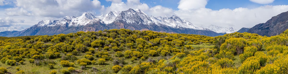
The Main Range and The Granites from Grey Mare Range
Passing Grey Mare Mountain to the west I then headed off track to the summit of The Granites. The eastern edge provides outstanding views from Jagungal all the way down to Mount Townsend and everything in between. Make sure you check out the link to the zoomable panoramas below. Having taken my time on the way up it was now after 1:30pm and time to head back. Now with a bit more downhill I finally got my skins off and made some much faster progress.
On the return, after leaving Strumbo Fire Trail, I followed the general line of the trail that heads towards Wesley Mountain, finding the first real sun softened runs of the day. These provided some great turning. I was back at Grey Mare Hut before 4:30pm.
Around 5:00pm some company arrived. Dave, also travelling alone, had come in via Long Plain Hut and was going to spend the night in Grey Mare Hut before heading out.
Serendipity, Damien had texted me a suggested day trip to Pretty Plain Hut, with map. Dave had come in over his version of that route. Better still he had the route drawn on his map in far greater detail. So I’m now planning to head that way tomorrow.
Day 5: Tuesday 27/08/2019 Grey Mare Hut – Pretty Plain Hut
Max elevation: 1714 m
Total climbing: 1073 m
Total descent: -1074 m
Average speed: 5.84 km/h
Total time: 07:35:22
I took up Damien and Dave’s suggestion in deciding to aim for Pretty Plain Hut today. Dave had worked on the route between 2012 and 2018 and today yesterday wrote detailed notes in the hut logbook to aid anyone wishing to navigate it.
I was away just before 9:00am, heading down towards and upstream along Back Flat Creek. Another good overnight freeze had the snow pack nice and hard providing another great workout for the ski edges. This has been the pattern throughout this trip, with no really discernible softening until after midday. The ski up to the pass between Rocky Bogong Hill and Ryries Parlour is all open and treeless. Dave’s route beyond, on the other hand, was totally different.
Once past Ryries Parlour there is, in about equal proportional, runs of open, tree and shrub free terrain between thickly packed trees. I may have had 20 of Dave’s waypoints on my map but I was much more appreciative of the tracks he had left yesterday! The route entails a number of ups and downs and a lot of very slow manoeuvring around tightly packed trees. With the very hard surface this was challenging, even only carrying a small daypack. Skins were used extensively, even on downhill sections to limit the potential build up of speed at the price of greatly reduced turning control.
On the way down somewhere near Jimmies Lookout, I was very surprised to see someone else skiing up the hill towards me. Con had taken track notes from Dave’s logbook entry and was also following his tracks! I found this amazing really, as apart from Dave, Con and myself there was only one other winter entry in the Pretty Plain logbook.

Pretty Plain Hut
It takes at least 2 1/2 hours from the top until exiting at Bulls Head Creek. Upon clearing the trees just before the creek, you get the first view of Pretty Plain Hut. A big jump had me across the creek and soon after at the hut. Pretty Plain Hut looks fantastic from the outside but is quite spartan inside. A single large table, bench chairs and open fire place in the first room whilst in the adjoining bedroom there are no bunks but plenty of floorspace.
I was away from the hut on the return leg by 1:00pm. I tried a different crossing point a little upstream after one boot had slipped down the grassy bank into the creek on the way in. The second, wider crossing was OK for crossing in plastic boots.
The return trip up “Dave’s Route” was way easier than the morning descent. With skins on and far less opportunity for gaining unwanted speed without room to turn. Back past Jimmies Lookout and up to Ryries Parlour took 2 1/2 hours.
It was a relief to be back onto the open slopes for the return trip to Grey Mare Hut which I reached at 4:30pm. My new room mate, Con was settled in by this time.
Clouds had been building since the middle of the day and it looked as if that was continuing, however, as it became dark they again disappeared leaving a crystal clear, moonless sky and a good opportunity for some more night photography.
Day 6: Wednesday 28/08/2019 Grey Mare Hut – Grey Mare Bogong – Rocky Bogong Hill
Max elevation: 1848 m
Total climbing: 514 m
Total descent: -495 m
Average speed: 3.91 km/h
Total time: 05:41:56
After four longish days an shorter locally based exploration was in order. With a forecast change approaching I headed back up towards Grey Mare Range just after 10:00am. The long flat ridge just above and to the west of the hut was followed to its northern extremity. From here there is an outstanding 360 degree panorama to be savoured. This is a must visit spot if you visit Grey Mare Hut in clear weather.
A couple of other fantastic vantage points were visited on the route around towards Grey Mare Bogong. The early morning was clear with a strengthening breeze and clouds building to the west.
Moving onto Rocky Bogong Hill the view to Tabletop and Jagungal were superb and phone reception strong, a good spot for lunch, more photos and checking in with home.

Jagungal from Rocky Bogong Hill
During the late morning the clouds had begun to start covering the range and beyond, darkening as they did. It was also becoming much colder, especially with a brisk breeze, so more layers were quickly put on. The return trip was much slower than I’d hoped as the lighting had become extremely flat and a quick downhill run would have been very hazardous.
I was happy to get back in the hut with Con. He was already back to greet me and provided great company for the afternoon and evening. With full cloud cover it looks like tomorrow will be a different sort of day.
Day 7: Thursday 29/08/2019 Grey Mare Hut – Back Flat Creek – Valentine Falls
Max elevation: 1644 m
Total climbing: 403 m
Total descent: -405 m
Average speed: 4.47 km/h
Total time: 03:27:15
Less than a centimetre of snow eventuated after last night’s change came through. By morning a cold breeze came and went periodically and the clouds were giving way to increasingly larger patches of blue sky.
Today was set aside to rest up before heading towards Jagungal tomorrow, so a short trip down the valley was in order. Some great turns were had on the way down to Back Flat Creek. My intention today was to find a safe, dry crossing near Geehi River. Back in the 1980’s Grey Mare Hut had been a regular destination of mine via this route, which climbed steeply through the heavily treed ridge that Valentine Fire Trail crosses just past Valentine Hut on the opposite side of the creek.

Falls on Back Flat Creek
Exploration along Back Flat Creek revealed two good dry crossing candidates above the Geehi River but none nearby below. Travelling solo and finding my plastic boots slipping a little convinced me to wait until I had company before further exploration, slightly longer legs would also be advantageous.
A good view of Valentine Falls is gained from near the Geehi River junction, so this would be a good day trip when the weather restricted you to lower elevations whilst out this way. I was back in Grey Mare Hut by 1:30pm after a 10:00am start and lunch along the way. Another star trail was shot after dark.
Day 8: Friday 30/08/2019 Grey Mare Hut – Smith’s Lookout – Strumbo Hill – Jagungal – Strawberry Hill
Max elevation: 2047 m
Total climbing: 875 m
Total descent: -717 m
Average speed: 5.04 km/h
Total time: 07:24:48
Blue skies saw the day in and I was away by 9:15am aiming to camp somewhere high with a good view of Jagungal. I crossed Back Flat Creek on a small, highly slumped snow-bridge, testing it first without my pack. It had been cold overnight so it was still well frozen. From here I headed up the creek valley to the east of the Grey Mare Fire Trail ridge, this provides a more gradual ascent but two hundred metres of trees to negotiate at the top before rejoining the firetrail. The snow was still hard with a few days worth of frost topping it off.
Progress along the Grey Mare Firetrail section was easy and smooth along a very gently undulating route. Near the top of Straight Creek I contoured east through the trees just to the south of the top of Strumbo Hill following the contours roughly parallel to the creek. From here I travelled another kilometre east where I found the elevated spot with good views towards Jagungal I had been seeking. This was located on the northern ridge off Strawberry Hill. By this stage a cold, brisk south easterly wind had kicked in.

Bogong High Plains from Jagungal
An afternoon trip to Jagungal completed the day. Evidence of recent visits persisted, but I didn’t see anyone else all day. With the cold wind persisted into the night, it was not suitable for tripod photography so I tucked myself up into my tent for an early night.
Day 9: Saturday 31/08/2019 Strawberry Hill – Mawsons Hut – Tin Hut
Max elevation: 1858 m
Total climbing: 344 m
Total descent: -296 m
Average speed: 4.86 km/h
Total time: 05:44:45
I woke at 4:00am finding the wind had gone. After much fiddling with gear I was out side setting up a timelapse over Jagungal, alas it wasn’t long until the sky started brightening predawn, at least I got enough for a photo.
It was cold early until the sun revealed itself at 7:50am. I was packed and away from camp shortly before 10:00am. Heading south around the eastern side of Strawberry Hill across smooth, open, treeless, firm packed snow made for straightforward travel. The very gentle descent to the Geehi River was followed by an equally gentle ascent to the saddle to the west of Tarn Bluff, before another gradual descent to cross Valentine Creek at Big Bend. There was no sight of water in either watercourse. From here it was a slightly steeper climb up the small ridge to Mawsons Hut for lunch, in the company of a blowfly, and photos.
The best part of travelling alone is the flexibility you have in your plans. For most of the trip I was intending to cross The Kerries next but on the spur of the moment thought I would head up along Valentine Creek to Tin Hut instead. I was hoping for one last chance at some night photography.
It was a very pleasant cruise up along Valentine Creek in the afternoon sun. A rabbit was sighted just before “Tin” saddle and phone reception obtained from on top and just above Tin Hut. You need to watch out at the door here, as snowmelt during the day water is pooling just inside the door before freezing to create a hazardous entry welcome for the unwary. It is not easily seen in the very dark entry.

Tin Hut
Having not seen another person since I said goodbye to Con at Grey Mare Hut on Thursday morning I wasn’t too surprised that Tin Hut was also empty. Here I now had a wonderful opportunity for some startrails with Tin Hut framed in the foreground. A carefully positioned supplemental LED light reflected off the snow lifting the hut out of complete darkness, as there was no moon. A single candle inside on the fireplace lit the interior and window, a reflection of the candlelight can be seen outside on the snow!
Day 10: Sunday 1/09/2019 Tin Hut – Gungartan Pass – Guthega Power Station
Max elevation: 1996 m
Total climbing: 551 m
Total descent: -1054 m
Average speed: 7.06 km/h
Total time: 05:28:04
I was away by 9:00am into a cold 50km/h headwind under a clear blue sky. A slow climb up the gentle headwaters of Finns River then Valentine Creek saw me at Gungartan Pass in an hour, even with many stops to savour the views one last time.
Not paying enough attention on my descent on the western, Schlink side I missed my turnoff into the creek that takes you close to Schlink Pass, instead ending up at Schlink Hut. The snow has remained very firm all week, at least until after midday when some softening began. This firmnace make it awkward heading across slopes, so just up from the hut I left the trail and headed down into Dicky Cooper Creek and followed it up to Schlink Pass instead. This was great as there were no frozen tracks to catch the skis and challenge the balance or edges to forcibly try to hold.

Southern end of Grey Mare Range from Gungartan PassI continued this theme on the descent from Schlink Pass following the Whites River creek-line instead, again an open and smooth surface to ski. Past Whites River Hut I tried skiing alongside but off to the side of the road which had two parallel sets of skidoo tracks and many ski tracks which would certainly provide a very bumpy ride and reduced control. I did come unstuck once, however, though choosing a small jump instead of the road, the legs yielding on landing under the weight of a still heavy pack and I was down for the only time on the trip.
The road had lost a lot of snow in the ten days I was out requiring half a dozen remove skis and walk moves. At the Horse Camp Trail, I ran into Murray whom I have completed a couple of trips with. He had just returned from Whites River Hut along the Horse Camp Aqueduct Trail and had good snow cover all the way.
The descent to Guthega Power Station was on soft but patchy snow forcing a walkout along the last 500m.
All up an outstanding trip with no really nasty weather to prevent my daily excursions and clouds usually clearing completely in the evenings to present brilliant moon-free stars right across the sky.
Clickable icons on a world map which open the related trip report
A detailed, searchable trip list with links to reports, photo galleries and other content
![]()
Hi there – great trip report! I found it while trying to chase down the description of the route from Grey Mare to Pretty Plain. I took some photos of the route description when I was at Derschko’s a few years ago but have lost the pics! If you’ve got it I’d love to get me hands on it – I have a trip planned up Jagungal way in a few weeks and would love to tack on a trip to Pretty Plain. Cheers!
Hi Mark,
I followed the tracks that David had left the previous day, his description of the route can be read from the Grey Mare Hut/Pretty Plain logbook entry he wrote at the time, follow the logbook links. My report includes my GPS track of the route.