
17/12/2014 – 19/12/2014 Snakey Plain Fire Trail – Wolseleys Gap – Jagumba Range – Snakey Plain – Wheelers Hut – Dargals Fire Trail – Broadway Top
Kosciuszko National Park, NSW
Ngarigo country
Distance: 35km Total Ascent: 1550m Total Descent: 1550m Time: 15 hours
Participants: Stephen Davies (Photos), Sue Davies (Report), Geri Louis, John Louis, John Meehan, Russ Pennell, Geoff Sim
After realising that since most of the participants in our party are now retired, our traditional, annual Wheelers Hut weekend walk could be moved to mid-week. This offering less road traffic and hopefully the chance for greater solitude. We agreed to meet on Tuesday evening at Three Mile Dam, just past the turnoff to Mount Selwyn ski resort. The temperature variation on the drive down was quite extreme – moderate on the coast (low 20’s), 37C whilst driving through Gundagai and then was a cool 12C at 3 Mile Dam. The March flies were out in force to greet us as we set up camp for the evening. A rain shower saw us scurry off to bed for an early night.
Day 1: Wednesday 17/12/2014 Snakey Plain Fire Trail Trailhead – Wheelers Hut
Max elevation: 1586 m
Total climbing: 363 m
Total descent: -363 m
Average speed: 3.98 km/h
Total time: 05:02:51
I managed to pause the GPS recording at our lunch stop at Snakey Creek before restarting near Tooma River. We did not walk that section “as the crow flies”.
We awoke to a beautiful morning and planned to leave camp to ensure time for a coffee stop at Cabramurra before we started out for Wheelers Hut. Sue was keen to pack up her beverages into the pack but could not find her tea and coffee bags, which were essential to her for the next three days. Being made aware by John Meehan of the presence around camp of some sneaky currawongs, the bag was found about ten metres from camp, discarded in disgust by the cheeky birds.
After a well-deserved coffee stop, we met John and Geri at the trail head about 3km west of Tooma Dam. We were soon on our way up the long hill on Jagumba Range and through Wolseleys Gap to join Snakey Plain Fire Trail at SMA1009 where we stopped for morning tea. John Louis and Steve compared cardiac complaints and the wives sympathised with each other along the way.

John L and Geoff leading the way up Jagumba Range
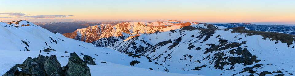
It was a spectacular day in the high country and our group of seven made good progress until Steve tried to assist Geri across Snakey Plain Creek. Both ended up on the ground when the assisting stick broke.
We arrived at Wheelers Hut via Wheelers Hut Fire Trail in time for afternoon tea. Steve, however, was nowhere to be seen. We assumed he had found something to photograph but he did in fact miss the turnoff and was close to the Tumut River before realising his error.
The evening was spent enjoying some Christmas treats and stories of past conquests.

Day 2: Thursday 18/12/2014 Wheelers Hut – Dargals Fire Trail – Wheelers Hut
Max elevation: 1657 m
Total climbing: 718 m
Total descent: -728 m
Average speed: 4.00 km/h
Total time: 07:00:14
The next morning we managed to get a group photo in front of the hut. We think this annual walk has been going for at least 30 years.

Dave, John Meehan, Geoff, Russ, John Louis, Sue, Steve and Geri at Wheelers Hut
Steve and Sue decided to stay another night with the aim of reaching Pretty Plain Hut today. They headed off around 8:00 am while the rest of the group walked back to their cars.
It was another lovely morning but was marred slightly by bushfire smoke. Steve and Sue headed off track, down from the hut and across the valley where they forded Dargals Creek and then Broadway Creek before walking through bush up the Dargals Fire Trail. Once on the trail, they followed it to the south, aiming to take a short-cut through the bush to Pretty Plain Hut. Once off-track progress proved to be a bit slow, a bit too slow. It was around lunchtime when we reached the descent into Pretty Plain Hut. There was still about three kilometres to travel, however, as this looked like it would be really slow going, so we decided to bail out to enjoy an easier afternoon. We headed back to camp.
[In editing this post in 2021 I noticed that the “Thunderforest – Landscape” map which I use to present the GPS tracks on this site showed a track less than 100m from where we were looking to commence our “shortcut” to Pretty Plain Hut. On further research, the “Pocket Earth” app on my iPhone also shows this trail and its name, “Granite Knob Trail”. This trail leads across to Pretty Plain Hut but is not shown on the last two editions of the printed 1:25,000 topographic maps!]

Sue amongst wildflowers at Broadway Top on Dargal Fire Trail
After having a refreshing dip in Dargals Creek near the diggings we returned to Wheelers Hut to find a new tent. We shared the evening with Paul and Margaret from Bairnsdale and exchanged adventure stories until bedtime.
Day 3: Friday 19/12/2014 Wheelers Hut – Snakey Plain Fire Trail Trailhead
Max elevation: 1597 m
Total climbing: 480 m
Total descent: -465 m
Average speed: 4.32 km/h
Total time: 02:51:33

Scarlet Robin nesting at Wheelers Hut
The next morning Steve harassed the local birdlife but managed to get some great shots of the male Scarlet robin (Petroica boodang) feeding its chick in a nest under the roof of Wheelers Hut.
We had a quick walk out, returning to the car by 12:30pm. We offered Margaret and Paul a lift back to their car but as the intrepid walkers were so close, they declined.
Clickable icons on a world map which open the related trip report
A detailed, searchable trip list with links to reports, photo galleries and other content
![]()