
20/07/2018 – 24/07/2018 Dead Horse Gap – Rams Head Range
Kosciuszko National Park, NSW
Distance: 41km Total Ascent: 2900m Total Descent: 2900m
Time: 19 hours Track Info
Participant: Stephen Davies (Photos, Report)
This solo skiing trip was my first snow camping adventure for 2018. It provided some great skiing to tune the legs for the season to come and the usual early winter variability in weather along with a couple of amazing sunsets. The greatest challenge though proved to be getting mobile phone reception to confirm my safety and report progress.

Day 1: Friday 20/7/2018 Dead Horse Gap
Max elevation: 1783 m
Total climbing: 201 m
Total descent: -14 m
Average speed: 2.21 km/h
Total time: 00:48:07
Weather watching is invariably central in planning a solo snow camping trip. So after watching forecasts change numerous times leading up to my departure I was still very uncertain as to what I could expect. “Windy with snow Friday night and then relatively calm until Thursday apart from an expected quickly passing front late Monday”. That should be OK, now lets see what happens.
Being retired I do what I can to restrict my driving to daylight hours, I’m always put off by the large number of big kangaroos carcasses roadside along the route. With the current drought, there seems to be more than usual.

The climb up from Dead Horse Gap
Not much to do today, apart from the long drive, except for the short climb up to my campsite in the late afternoon. I was greeted at Dead Horse Gap by overcast skies with some light wind and light snow showers. A good cover of fresh light snow covered the climb. Fortunately a good set of recent tracks meant my skis didn’t sink, making the climbing easy despite carrying five days of food and lots of camera gear.
I arrived at camp without running into anyone else, just in time to have camp half set up before it got dark. A relatively calm night followed.
Day 2: Saturday 21/7/2018 Dead Horse Gap
Max elevation: 2025 m
Total climbing: 959 m
Total descent: -959 m
Average speed: 6.27 km/h
Total time: 06:16:53
Even after a good night’s sleep I didn’t manage to get out to ski until 9:30am. It may have had a lot to do with being cold until the sun hit the tent at 7:40am.

Camp below South Rams Head next to tributary of Bogong Creek
A first-up trip straight up to the top of the ridge directly above camp established that there was an almost complete snow cover with just the tops of higher grasses poking through . It was a little crusty in sections until past the treeline, above which the wind had transformed the snow into a firm surface.
From here I went back to the car to collect a couple more items and test the snow down lower amongst the trees.
The afternoon saw two more runs up to the ridge top completed before retiring to the tent with lengthening shadows across the slopes by 4:00pm. It should be noted that most of the day at this time of the year sees the sun directed straight into eyes climbing up to Rams Heads.
Just before 5:00pm I was out again wandering about with camera ready to enjoy the golden hour, sunset and blue hour. It was magic, nature put on a very spectacular show.
After settling back into the tent the home dried Chili Con Carne was prepared and enjoyed. The usual safety and catchup call home to Sue followed as well.
Day 3: Sunday 22/7/2018 Dead Horse Gap – Rams Head Range
Max elevation: 2064 m
Total climbing: 623 m
Total descent: -623 m
Average speed: 6.17 km/h
Total time: 05:25:39
After a very cold calm clear night it was fantastic to see blue sky this morning, with the first sun rays striking the tent again at 7:40am. Now that makes for a happy snow camper.
Morning preparations when snow camping always seem to take a ridiculous amount of time. It was no different today. So after gearing up with a day pack, camera bag and skins bag I was finally away about 9:30am, heading straight into a bitterly cold westerly breeze with clouds sitting ominously about the peaks. I had decided todays destination would be Mount Kosciuszko.
Progress was slow as it was pretty uncomfortable, even with four layers on top and neoprene chin mask in place. Quite breathtaking really, so much so that it seemed to sap lots of energy from my body, further slowing progress. Once a little way above the tree line, it became colder again as I was now became shrouded in the clouds hugging the Rams Head Range. The phone reception this morning was none existent, despite numerous attempts in a number of locations, not too concerned as reception up around here does come and go.

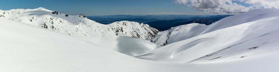
High on Rams Head Range
After tentatively reaching the base of Rams Head and with visibility under 100m I decided Kosciuszko could wait for another day. After getting back down in amongst the trees it amongst seemed another day, as blue skies beckoned just beyond and below. A very cool run back to the tent saw me jumping right in to escape the wind and have an early lunch.
The afternoon surprised again, as the wind mostly disappeared along with the clouds across the tops. Another trip to the top of the ridge provided views out to the west and revealed that the clouds were still lurking just below on the western slopes. It was however, a much more pleasant experience than just two hours earlier. The hope that phone reception was now back proved false.
Feeling unusually fatigued most of the day I called an early end to skiing and enjoyed a short period of warmth bathed in sunlight before the sun dropped below South Rams Head at 3:40pm, putting my campsite in the shade and a causing a sudden, large drop in temperature.

Sunset star over South Rams Head Trig
Tonight I have home dehydrated Beef Madras Curry, another tasty winner. By now, still with no Telstra reception, I am worried that Sue will be very concerned that she has not heard from me at all today.
Day 4: Monday 23/7/2018 Dead Horse Gap – South Rams Head
Max elevation: 2031 m
Total climbing: 1113 m
Total descent: -1113 m
Average speed: 5.61 km/h
Total time: 06:26:28
A much warmer and peaceful night’s rest with almost no wind.
Plenty of blue sky this morning but cool again. There is still no Telstra reception and I need to let Sue know all is well. So I departed camp for South Rams Head at 9:00am to try there and hopefully run into some other people. Near the top I did meet three other people, including one guy that I had run into on Saturday. He informed me that Telstra were been doing some work on their Thredbo network which might account for having no signal since Saturday, not sure if “SOS only” counts! One of the other people there allowed me to send off an I’m OK message to Sue thanks to him being an Optus user. The huge question is, why did I not receive an SMS from Telstra saying they were working on their Thredbo network.
A was a great run down through through the trees, although you need to carefully pick a line as they get very thick in pockets. After two more runs from the top I was back to the tent for a quick snack before heading straight back up for a final run. By this time the forecast windy change had arrived with some cloud so it had cooled off considerably from middle of the day.
A much more satisfying day than yesterday, completing twice the vertical and feeling much better than the sloth I felt yesterday. It was interesting that one of the other people I met today also felt the same lethargy yesterday, perhaps the cold moisture laden wind was diverting too much of our energy supply to heating our bodies?
With heavier clouds about the sunset failed to live up to standard of the two previous nights.
I reflected on the partially eaten snow gum leaves I had seen around and above camp this trip but had no answer as to what might have been eating them.
Home dehydrated lentil dahl tonight, yet another tasty winner. Still no Telstra reception, so I hope this morning’s SMS from someone else’s phone reached Sue and eased her mind.
Day 5: Tuesday 24/7/2018 Dead Horse Gap
Max elevation: 1783 m
Total climbing: 34 m
Total descent: -218 m
Average speed: 5.09 km/h
Total time: 00:50:54
With the weather now deteriorating there was only one thing to do today – pack up and go home.
Under the weight of a heavy pack – lots of camera gear, not mention human waste (leave no trace after all!) it is always a challenge to get back down to the carpark in one piece. More strength in my legs might help but under the tight conditions amongst many, in places, tightly packed trees and on at times unpredictable snow that wouldn’t totally solve the challenge. So, travelling alone, extreme caution is mandatory and I managed to reach the carpark without falling, although I also made no attempt at either a telemark or parallel turn!
Back in Jindabyne I finally regain phone reception and an SMS from Telstra stating that they were doing some work around Jindabyne over the next couple of days that could impact on reception! Where was the Thredbo work message two or three days ago?
Having not heard from me, my wife, Sue had become really concerned about me and phoned the police who were about to send out a search party until she let them know about the SMS from a strangers phone. The officer she was speaking with said he would still need to investigate, as the stranger could have killed me and stolen my gear! How reassuring. Sue was also, later, instructed not to kill me for failing to make contact!
Away for those wondering, I always carry a phone, external battery pack and PLB. The obvious weakness with this system is that if your wife thinks the worst (your dead or unconscious) and there is no phone reception you have no way to let home know all is still OK. It may be time to invest in the Spot system which allows remote access route tracking and fixed messages to be sent via satellite.
Clickable icons on a world map which open the related trip report
A detailed, searchable trip list with links to reports, photo galleries and other content
![]()
Hi Steve – just looking at your site – I am an older bushwalker – 58- who doesn’t get out much ( I still have a teenager at home) – but occasionally (due to a lack of interest from family and friends) likes to get out on my own – am glad to see another solo traveller – I question myself sometimes but am really well prepared, and like you, so careful not to put a foot wrong to prevent falls and injury. I too am thinking of buying a Spot Me – it seems to be the perfect safety solution…Good travels and thank you for your great photos and trip notes. Cheers
Francesca
Thanks Francesca, I appreciate your comments. I’m an even older bushwalker at 62 who at times runs out of people to travel with. After my wife called the police earlier this year to start a search for me (Telstra failed to text me that there were going to be possible outages due to local work on their network) I also looked into another layer of safety devices. I always carry a PLB but if you are alone and completely disabled you would not be able to set it off. I looked at, and discounted, all of the Spot devices. They use a small and therefore limited private satellite network which people have reported as having limited coverage/reliability. Yellow Brick and Garmin Inreach are two way satellite SMS messaging systems that use much larger satellite networks which should provide much better coverage and reliability. The downside with both is their high initial cost and the subscription plan (like phone plans) that are also expensive for any casual user.