
11/9/2016 – 16/9/2016 Day trips out of Southern Alps Lodge, Charlotte Pass
Kosciuszko National Park, NSW
Ngarigo country
Distance: 71km Total Ascent: 4100m Total Descent: 4100m Time: 28 hours Track Info
Participants: Angela Barton, Margaret Bat, Jopie Bodegraven, Derrick Brown, George Copeland (12/9-16/9), Helen Cromb, Karen Darby, Stephen Davies (Report, Photos), Trish Elmore, Bill Filson, Jaclyn Fletcher, Bill Fordyce, Geoff Kelly, Tim Hager, John Hardy, Neil Hichson, Gina Hopkins, Bob Horder, Ian & Caroline Houghton, Kathy Husselbee, Tracey Johnson, Sheila McDowall, Merilynl Metzenthen, Bill Metzenthen, Tony Murphy, Gordon Newell, Maggie Pavlou, Colin Ridley (Leader), Marianne Watt, Robert Webber, David Whittle, Peter Whittle, Graeme Wood, Rhonda Wood
Day 1: Sunday 11/9/2016 Southern Alps Lodge – Snowy River – Rawson Pass return
Max elevation: 2149 m
Total climbing: 735 m
Total descent: -737 m
Average speed: 6.06 km/h
Total time: 06:23:54
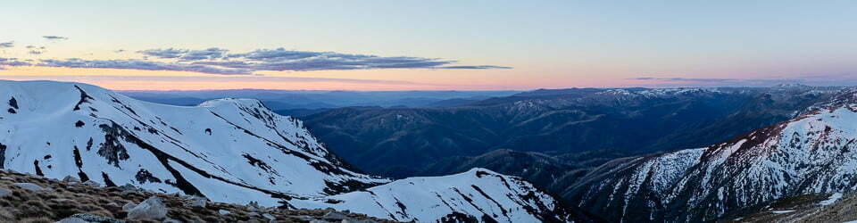
A large group of us departed from Southern Alps Lodge at 9:00am headed for a Mount Townsend tour. After sidling across and up the downhill slopes we regrouped at Charlotte Pass before heading several kilometres along the road towards Mount Kosciuszko. There was a clear blue sky with a few light clouds emerging over the ridge tops. From the road our aim was Mueller Pass but there were no snow bridges to be found this low down the river. At this crucial junction the party divided examining the options. Some electing to do the river crossing and others, including myself, choosing to keep our feet dry and follow what snow we could find upstream until we met a snow bridge. By the time we found likely crossing candidates we were a couple of kilometres further upstream and adding distance to our intended target. As the weather was also changing quickly we decided to head straight towards Seamans Hut for lunch.
By this time the cloud had really started to move in and a very cool wind introduced itself to us. We found a party of four staying in the hut, with the pot belly provided some welcome warmth. Heading onwards towards Mount Kosciuszko after lunch we were soon in the clouds. The very limited visibility we encountered at Rawson Pass preventing us proceeding to the summit. The option of returning via the tops was considering but being in cloud, we returned via the road. This proved a wise choice as at all times on our return the cloud level after re-passing Seamans Hut remained just above us.

NSC party retreating from Mt Kosciuszko attempt
The rest of the party had made it just over Muellers Pass before also calling off their attempt and heading back. The day although thwarted by the incoming and lingering cloud, got us out in the fresh air and on the snow.
Day 2: Monday 12/9/2016 Southern Alps Lodge – Carruthers Peak return
Max elevation: 2178 m
Total climbing: 1155 m
Total descent: -1155 m
Average speed: 6.59 km/h
Total time: 07:37:22
Again another large party of us departed around 9:00am, this time targeting Carruthers Peak. This was our choice as it provided a straightforward escape if the weather deteriorated as was forecast for the afternoon. A short section of scrub bashing was required to get down to Foremans Crossing. Here, most elected to remove boots and use wet suit booties, crocs or old shoes to ford the river, several hopped across in boots but most of those ended up getting them a little wet.

Crossing the Snowy River at Foremans Crossing
Again the weather was clear and calm as we commenced the climb. After a another hour or so the rest of the party stopped for morning tea as I elected to continue alone in the one push to the top. On summiting, I was greeted by a very cool breeze and lots of cloud hanging around the peaks just to the west of the range. These clouds, at times, produced some spectacularly moody lighting on the area which always provides fantastic views in all directions.
After the rest of the party arrived and had lunch, lots of photos were taken and it was time to get out of the cold. Again the party split, about eight returning the way we’d come, the rest apart from myself headed down and around towards Club Lake where they enjoyed several downhill runs. I had elected to stay on the main body of the mountain where I got in four long runs before being enveloped in clouds and heading home.
One last short detour around bare grass to the top of the hill directly above Foremans Crossing saw in a few more turns before rejoining our main group at the crossing. At Colin’s suggestion we followed the snow downstream before climbing up along runs of snow all the way back to Charlotte Pass. By this time, the downhill slopes had frozen solid, providing a very challenging terrain of frozen old tracks and turns to negotiate before we could return to the comfort of the lodge.
Day 3: Tuesday 13/9/2016 Southern Alps Lodge – Watson Crags return
Max elevation: 2185 m
Total climbing: 1286 m
Total descent: -1247 m
Average speed: 6.40 km/h
Total time: 07:39:13
Again there was a forecast for possible afternoon rain. However, we returned to Foreman’s Crossing via the new route, taken the previous afternoon, aiming for Watsons Crags. This provided a deteriorating weather option of Blue Lake if needed. After about an hour’s climb we stopped for morning tea before continuing up Carruthers Creek. After some sidling along its true right bank some people crossed a 200m section of grass whilst others backtracked a little before descending to the creek and following the snow upstream on the other bank. Another uphill section ensued before we were on top of the range. Again lots of clouds were lingering to our west but only occasionally encroaching over our heads.

Approaching Watsons Crags
By the time we reached Watson Crags it was lunchtime. I skipped that option and summited the first peak before completing four runs. By this time everyone else was off, some for the run I’d just done and others making descents off the northern side of the Crags in a number of different spots. No longer able to resist, I also did a run down the first gully. As fantastic as that had been on hero snow there was still the small matter of climbing back out, as expected this was a real slog, made a little more difficult by only having the shorter kicker skins to use! Traction was frequently lost when needing to climb a little steeper, oh for the full length skins!
By the time I returned to our lunch spot the main body of our party had already left, the six of us who remained made the climb back to the top of the ridge together before having a fantastic run back down to the Snowy River. Our return to Charlotte Pass saw us back on the late afternoon resort slopes, fortunately not yet frozen. We all had a much better ski home down the resort runs than yesterday.
Day 4: Wednesday 14/9/2016
An enforced rest day due to the unpleasant weather, a combination of rain and wind.
Day 5: Thursday 15/9/2016 Southern Alps Lodge – Guthrie Ridge return
Max elevation: 1881 m
Total climbing: 606 m
Total descent: -614 m
Average speed: 5.06 km/h
Total time: 03:22:51
Presented with poor weather we needed to keep ourselves in lower and more sheltered environs. Bill Fillson lead a smaller party of us of down the road with the aim of circumnavigating Mount Guthrie. It was windy, misty and somewhat wet. After departing the road we made tracks through soft snow that in places was not supporting our weight very well. Weaving up and down between closely spaced trees meant there we lots of hazards impeding our way as we worked further and further around he north side of Mount Guthrie. Approaching the western side the wind proved it would make our lives very unpleasant so it was generally agreed not to proceed.

Negotiating snow gums on Mount Guthrie
We back tracked a little way and found a lower depressed bowl which offered a little protection from the wind. Here we put all our warm and waterproof gear on before sitting down and having our lunch. There was no desire to linger so we were soon donning our skis again and turning for the comfort of the lodge. One couple headed off before the others, seemingly on an odd choice of route so Damien, George and myself quickly followed to keep an eye on them and make sure they got back OK.
The rest of the group had an easier journey following the tracks we had made on the way in. The new lower route we followed provided the same challenges as the way in. Fresh tracks and lots of obstacles. We all joined up back near the road. Turned out the two we chased after had not even been part of our morning party, only joining us for lunch!
Day 6: Friday 16/9/2016 Southern Alps Lodge – Mount Stilwell flanks circuit
Max elevation: 2041 m
Total climbing: 360 m
Total descent: -366 m
Average speed: 3.62 km/h
Total time: 02:52:23
A cloudy, cold and windy day greeted us. A repeat of yesterday.
We headed out hoping to get high onto Mount Stilwell by following the valley up along the eastern edge of the resort slopes. The weather was poor, as was the snow, wind having exposed lots of ice. After a group huddle part the way up had us making some decisions, largely formulated around keeping everyone from getting lost in the poor conditions. We broke off into smaller groups with different objectives, none of which involved going very far. Margaret, Gordon and I decided on a photographic tour amongst the ice frosted boulders and trees.

Exploring the landscpae
Cold and windy, we went from outcrop to outcrop looking closely at some of nature’s fine details. Lots of lichen encrusted rock, icicles, ice sheets separated from the rock with water dripping beneath and out from underneath. Fantastic shapes and forms everywhere. The snow gums were much the same, many distorted from years of exposure to the strong westerlies of these parts.
We slowly moved around and down through the trees whilst edging closer to the lodge, all the while looking for the unusual. We all collected plenty of interesting photos before heading back into the welcome warmth and comfort of the lodge.
Sue had remained home this week. After several visits to the doctor and various tests she was diagnosed to have para-influenza type 3, a chest infection and pleurisy. She was very unwell for about two weeks.
Clickable icons on a world map which open the related trip report
A detailed, searchable trip list with links to reports, photo galleries and other content
![]()