
Wednesday 6/04/2022 Park Office Carpark – Monolith Walk – The Monolith – Echo Point – The Gorge – Lake Catani Walking Track – Lake Catani Campground
Mount Buffalo National Park, VICTORIA
Taungurung Country
Participants: Stephen Davies (Photos, Report), Sue Davies
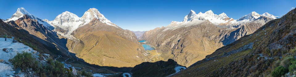
Starting opposite the National Parks Office near Lake Catani, this walk takes you up through the forest towards a huge granite boulder known as The Monolith. Although there is no access to the summit, there is a great view back towards Lake Catani from its base.
Max elevation: 1405 m
Total climbing: 396 m
Total descent: -425 m
Average speed: 3.91 km/h
Total time: 02:37:10
The final approach to the Monolith is via a metal staircase. The Monolith itself was first climbed in 1893 via a rope thrown over its top to pull up a ladder. For years there was a ladder to the top but was later deemed to be too dangerous and removed.

The Monolith
From The Monoltih we followed Monolith Track through the forest to Mount Buffalo Lookout and the hang glider take-off ramp just a little further around. Here there are fantastic views of the stained and weather-beaten granite cliff faces and across the valley below.
To complete today’s walking we continued following The Gorge – Lake Catani Track back to Lake Catani Campground.
I remain incredulous there is no mention of how the local indigenous people viewed any of the features we have seen in Buffalo National Park. I’m sure their dreamtime stories would have been fabulous.
The Mount Buffalo National Park Visitor’s Guide states
Monolith Track approximately 1.8km, 1 hour one way
Monolith Track can be accessed from the carpark opposite the Park Office, from the Gorge carpark or from the VicRoads sheds. The Monolith offers 360 degree views of the plateau. Return or continue along one of the other tracks mentioned.
Information on National Parks signage along the way
THE MONOLITH
The first recorded climb of the Monolith was by Edward Carlile in 1893. Carlile threw a rope attached to a wire ladder over the top of the rock.
This wire ladder remained in place until the present timber ladder was constructed around the turn of the century.
The Monolith continues to be significant for its recreational and historic values. However, the ladder is unsafe by today’s standards and has been closed due to the risk to public safety. It remains in place as a reminder of early tourism developments on Mount Buffalo.
The local flora, fauna, geology, history and some other walks (ChatGPT)
Mount Buffalo National Park in Victoria, Australia was known for its diverse local flora, fauna, geology, and history, as well as its scenic walks.
The local flora consisted of alpine heathlands, woodlands, and meadows, dotted with a variety of endemic wildflowers, such as the colourful alpine daisy. The fauna included various species of marsupials, such as the eastern grey kangaroo and the Tasmanian devil, as well as various bird species, including the spotted quail-thrush and the flame robin.
The geology of Mount Buffalo was characterized by granite formations, which were over 400 million years old and provided a glimpse into the ancient geological history of the region. The mountain itself was a distinctive landmark, rising to an elevation of 1723 meters above sea level.
The area also had a rich history, with evidence of indigenous occupation dating back thousands of years. Rock art and stone tools could be found scattered throughout the area, bearing witness to the rich cultural heritage of the indigenous peoples who lived there.
Visitors to Mount Buffalo National Park could take part in several walks, including the Eurobin Falls Walk, which offered a scenic hike through the alpine landscape, providing views of the waterfall and the surrounding wilderness. The walk was approximately 5 kilometres and took 2-3 hours to complete, providing ample opportunity to explore the local flora, fauna, geology, and history of the area.
Clickable icons on a world map which open the related trip report
A detailed, searchable trip list with links to reports, photo galleries and other content
![]()