
Tuesday 6/02/2024 Carr Villa Hut – Big Opening – Ben Lomond – Legges Tor (1572m)
Ben Lomond National Park, lutruwita / TASMANIA
Ben Lomond Country
Participants: Stephen Davies (Photos), Sue Davies (Report), Geri Louis, John Louis
We had intended to leave for the Bay of Fires today but Steve came up with a last minute suggestion to go to Ben Lomond. It was about a 50 minute drive from our camp at Myrtle Reserve, along mainly reasonable dirt road to the start of the walk at Carr Villa. The view from the car park was already impressive, with cliffs of basalt columns surrounding us. Legges Tor was once thought to be the highest peak in Tasmania but is readily accessed via this easy grade walk.
Max elevation: 1572 m
Total climbing: 362 m
Total descent: -363 m
Average speed: 2.81 km/h
Total time: 04:20:05
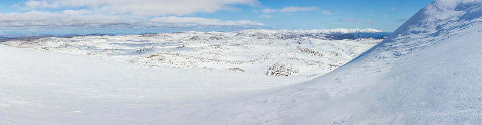
The trail climbs gradually and soon enters an extensive boulder field through which we were thankful of the efforts made to form the track. During the day there was still quite a lot of rock hopping required up through the scree slope. Past the scree, the trail leads to a broad saddle called Big Opening. The alpine vegetation in this section was stunning. There were delicate flowers, carpets of green moss, flowering shrubs and lichen-covered rocks resulting in a very colourful landscape.

Alpine landscape midway along Summit Pass Track
We followed aging snow poles the whole way. Before the summit, we reached an old hut and a memorial plaque. Close to the summit, there were several buildings and ski lift equipment. From the top, we were fortunate to have a clear day with expansive views all around as far as the coast. We enjoyed lunch in the sunshine before we retraced our route back to Carr Villa.
This walk is a relatively easy way to enjoy stunning views and soak up the precious alpine environment without too much effort.
Geri’s Dairy Entry for the Day

“Original plan was to move on to the Bay of fires today but Steve put forward an alternative plan, to do a walk to Ben Lomond. So after a mix of hesitation, worry that the day would be too long, the walk would be too long with too much elevation, etc and discussion a plan was hatched to rebook our sites at Myrtle for the night, drive to Carr Villa, and walk the 7 km to Ben Lomond on the Summit Pass route to Legges Tor and then return to the car the same way.
The weather was amazing; cool to start with then cloudy, but we soon warmed up possible showers John’s Willy weather forecast was 3° on top, so we made sure we carried some extra warm gear and rain coats. No showers and 14° on top – no need for the extra gear all day. Jumpers were taken off a few times.
The climb was gradual over many large and small boulders and through some colourful and picturesque alpine meadows; and taller alpine shrubs on the lower slopes. The track was gradual and old, weathered snow poles guided us across the expanses of rocky sections. There was mud and pools of water along some sections through the alpine meadows, but there was always a good stepping rock to see you through and keep your boots dry. There were many a photo step with beauty and majesty all around. We were all glad we did this walk. We met a few people, but they all seemed to be doing the summit loop walk from the Ben Lomond village.
Two other hikers were setting off from Carr Villa as we arrived back, a late start but they looked young and fit. After a coffee for John and Sue from Suey the Barista and another caravan phone call from Ian, we decided to drive the short distance up to the village to check it out. This provided us with spectacular views of the basalt columns surrounding the mountains and an excursion up and down Jacobs Ladder – a steep section road with quite a few switchbacks. – a few photos stops at lookouts. The route taken from the camping ground was along the mostly unsealed Camden Rd which was mostly well graded esp. compared to the road in the national park which contained many corrugations and potholes, but Steve handled all the driving in the Trakkadu with skill and ease and came into home well under the suggested time it would take…

Fauna sitings today: a green parrot who was very obliging to stand still in a clearing at Carr Villa, • many black alpine skinks, a couple of different skink varieties, • Steve saw a small snake = yellow tailed black cockatoos back at campground and two wallabies near the village.”
Information on Parks Tasmania signage along the way
If the drive up here hasn’t taken your breath away then this view probably will – and if you’re here on a windy, wintry day the cold air most certainly will. You are standing on the edge of the highest rock plateau in Tasmania. The summit, Legges Tor (1575m), is the second highest peak in Tasmania and the roads up here are the highest in Tasmania.
High-altitude living has its challenges. You’ll meet some of the plants and animals that do it, but first, how did Ben Lomond come to be?
The making of Ben Lomond
1. SWAMPY BEGINNINGS NEAR SEA LEVEL (200-174 million years ago) The Ben Lomond area was once close to sea level. It was a vast silty plain of peat-filled swamps and lakes whose sediments compressed to form sedimentary rock.
2. A STRESSED EARTH CREATES DOLERITE (174-55 million years ago) The earth’s crust began cracking as the continents began to move, enabling lava to seep up through the cracks. In the Ben Lomond area, the lava stopped at the base of the sedimentary rock and cooled to form the igneous rock dolerite. The dolerite cooled so quickly that it cracked into polygon-shaped columns, several metres wide and up to 300 metres deep. The columns can be seen around the edge of the plateau and the column tops can be seen on top of the plateau.
3. EARTHQUAKES RAISE BEN LOMOND (55-2 million years ago] Ben Lomond started to take its present shape and height when two major faults occurred on either side of Ben Lomond raising it up in the centre as a wide flat mountain. This process took about SU million years. Over a long period of time, wind and water gradually removed the softer sedimentary rock, exposing the hard, cracked dolerite surface and its impressive columns.
4. ICE SHAPES BEN LOMOND (2 million-10 000 years ago)
“The climate cooled and an ice cap formed on the plateau. The ice flows scoured and smoothed the dolerite rock, leaving behind smoothed column tops on the plateau surface (look for them around the ski village), and small glaciers that scoured down the mountain slopes, leaving mounds of rubble (moraines) as they melted (visible at the campground). Ice action caused the columns around the edge of the plateau to fracture, tumble and form backfields and scree slopes (fields of broken rock). Ben Lomond has the most extensive blockfields and scree slopes in Australia.
5. ALL QUIET ON THE HOME FRONT? (10,000 years ago-present)
Not exactly. At this altitude, ice action continues to slowly wear away the dolerite columns. It you look at the tall columns, you may see evidence of this happening, Water is seeping into cracks, freezing, expanding and slowly prising the rock columns apart, until eventually, they tumble. Strong winds deplete the soil layer, making it difficult for plants to establish. It may be quiet, but nature hasn’t yet taken a break.
Living with snow
A surprising variety of alpine plants survive the snow, severe frosts and strong icy winds often encountered on the plateau. How do they do it? Their leaves are often small, hard and closely packed on the stem to protect them from the blasting winds. And snow is not as dangerous to plants as it might seem – in fact, it’s actually helpful! A blanket of snow laying over plants insulates them, protecting them from being snap frozen by frost. Notice the characteristic wind-pruned shapes of many of the plants
However few birds and animals are able to cope with the extreme conditions up here.
Wedge-tailed eagles or other birds of prey may occasionally be seen soaring above the plateau. Tasmania’s own little alpine skink (restricted to the mountains of northern Tasmania) lives in cosy spots between sun-warmed rocks. The carnivorous eastern quolls can be seen around the ski village (even during winter) seeking out small bugs, or if they’re lucky, small birds and mammals. See what else you can find living the high life!
The local landscape features, geology, scenic highlights, flora, fauna, indigenous history, white history and other walks in the area (Gemini)
Ben Lomond National Park: A Tasmanian Tapestry of Alpine Splendour and Ancient Connections
Ben Lomond National Park, a crown jewel of Tasmania’s Central Highlands, boasts a captivating tapestry of alpine landscapes, diverse ecosystems, and a rich cultural heritage. From snow-capped peaks and glacial valleys to vibrant heathlands and towering forests, the park offers a haven for nature lovers, outdoor enthusiasts, and those seeking a glimpse into Tasmania’s past.
Local Flora:
The park’s diverse habitats support a rich variety of plant life, showcasing adaptations to various altitudes and climatic conditions.
Alpine heaths: Above the tree line, windswept alpine heaths dominate the landscape, characterised by low-growing shrubs like Richea scoparia (Scoparia heath), Photopsia rosea (Rosy heath), and Baeckea gunniana (Gunns Baeckea). These resilient plants endure harsh alpine conditions, often adorned with colourful wildflowers during the summer months.
Subalpine woodlands: Below the tree line, subalpine woodlands offer a haven for towering pencil pines (Athrotaxis selaginoides) and snow gums (Eucalyptus pauciflora). These hardy trees provide habitat for diverse birdlife and contribute to the park’s scenic beauty.
Wet eucalypt forests: Lower slopes boast wet eucalypt forests, dominated by majestic species like silvertop ash (Eucalyptus delegatensis) and mountain swamp gum (Eucalyptus globulus maidenii). These forests provide vital habitat for various animal species and contribute to the park’s water regulation and biodiversity.
Rainforests: Sheltered valleys harbour pockets of lush rainforests, teeming with ferns, mosses, and a variety of tree species like myrtle beech (Nothofagus cunninghamii) and celery pine (Phyllocladus aspleniifolius). These rainforests offer a glimpse into Tasmania’s ancient Gondwanan heritage.
Local Fauna:
Ben Lomond National Park provides a haven for diverse native Tasmanian fauna, adapted to various habitats and altitudes.
Mammals: Keep your eyes peeled for agile wallabies (Macropus parma) and pademelons (Thylogale brunii) grazing in the heathlands. Spot the elusive Tasmanian devil (Sarcophilus harrisii) or hear its distinctive calls at night. Look out for the shy platypus (Ornithorhynchus anatinus) in the park’s waterways.
Birds: The park is a birdwatcher’s paradise, with diverse species like wedge-tailed eagles (Aquila audax), peregrine falcons (Falco peregrinus), and colourful parrots like the eastern rosella (Platycercus eximius) soaring through the skies. Smaller birds like the Tasmanian thornbill (Acanthiza ewingii) and the yellow-throated honeyeater (Meliphastes luridus) flit through the forests.
Wedgetailed eagle in Ben Lomond National Park, Tasmania
Reptiles and amphibians: Look out for basking lizards like the heath monitor (Varanus giganteus) and the mountain skink (Eulamprus heathi). Spot the spotted tree frog (Litoria punctata) near water bodies.
Indigenous History:
The traditional lands of the Palawa people encompass Ben Lomond National Park. Evidence of their long connection to the land can be found in archaeological sites like middens and stone artefacts scattered throughout the park. The park recognises and respects the ongoing cultural connection of the Palawa people to their traditional lands.
White History:
European explorers first arrived in the area in the early 1800s. The park was established in 1968 to protect its natural and cultural values. Early European activities included mining, grazing, and timber harvesting, leaving some historical remnants within the park.
Clickable icons on this world map will open the related trip report
A detailed, searchable trip list with links to reports, photo galleries and other content
![]()