
Tuesday 22/02/2022 Cascade Trail Carpark – Cascade Trail – Thredbo River – Bobs Ridge – Cascade Creek – Cascade Hut
Kosciuszko National Park, NSW
Ngarigo Country
Participants: Stephen Davies (Photos, Report), Sue Davies
It was a very cool summer night last night at Nagiro Campsite, the morning greeting us with low clouds. On our arrival at the Cascade Trail Carpark we wondered what was going on as a convoy of four, four wheel drive vehicles joined us at the same time as three motor cyclists.
Max elevation: 1793 m
Total climbing: 1038 m
Total descent: -1034 m
Average speed: 3.86 km/h
Total time: 07:02:02
We managed a 9:00am start from the carpark just as the cyclists rode off. The National Parks convey unlocked the gate and drove out of sight up the fire trail.
As the sun tried to peek out from behind the clouds we were excited to see thousands of spider webs covered in dew glistening in the morning light. Some trees had at least ten resident webs, the webs were also plentiful on the grasses below. This was a really spectacular sight, all within the first kilometre.
A couple of kilometres in the clouds started to disperse. Once across the Thredbo River, we caught up will the National Parks team of about eight personnel. Their first task of the day was a check the traps set the day before for endangered Alpine she-oak skinks. They had caught one. This was a follow on from a study being done by a PHD student. From there they were settings up traps for Broad toothed rats, again part of their conservation work. We asked them which species of spider may have been responsible for all the webs we had seen, as there were no spider experts in their team, they were unable to help!
We passed a sole walker early who had camped overnight below Bobs Ridge. He reported a light overnight frost near his camp. He was very unhappy with all the brumby dung in the area, as when he finally found a grassy, dung free site to pitch his tent, he was disgusted to find his tent was pitched downwind of a very pungent fresh deposit. A while later we passed two girls who had camped overnight next to Cascade Hut.

Forest past Bobs Ridge
After the meander along the Thredbo River, the steady climb up towards Bobs Ridge required a bit more exertion. We had really been taking our time with photo stops, plenty of wildflowers to admire and views down to the upper Thredbo River and across to the Rams Head Ranges.
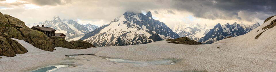
Heading down from Bobs Ridge the trees increase in height and density. The views are now down south towards The Pilot and Victorian Alps. From Bobs Ridge there is a long steady descent of about 400m over 4km until you reach Cascade Creek, which sits in a treeless “frost hollow”. About another kilometre along, don’t miss the turn-off to the left to Cascade Hut. Sue overshot by a 100m until I called out to her back.
We checked out Cascade Hut before enjoying our lunch sitting on the outside bench seat amongst the grass and shady trees.
The sun was out for the climb back to Bobs Ridge. Along the way, we refilled our water bottles at the Cascade Creek crossing where we encountered a couple of ebikes heading towards the hut. Very shortly after those same bikes were powering back up the hill.
Down past Bobs Ridge I sighted about six brumbies just up from where the National Parks team had been looking for the endangered Alpine she-oak skinks. Perhaps the one they had seen was squashed under a brumbies hoof?
Arriving back at the car at 4:00pm we were both very happy, as this had been the longest hike we had done for a long time. Sue enjoyed soaking her feet in the river with a cold drink after the 21k walk.
Clickable icons on a world map which open the related trip report
A detailed, searchable trip list with links to reports, photo galleries and other content
Information on NSW National Parks signage along the way
Cascade Trailhead
Budjeree Tidbillaga – Ngarigu mittang
Welcome to the Snowy Mountains – Ngarigu country
Expansive and diverse forest types and a rich cultural history
Cascade Trailhead is the northern entrance to the 80,500 hectare Pilot Wilderness Area.
Ranging in altitude from 1830 metres (The Pilot) to just over 200 metres on the Lower Snowy River, it encompasses diverse forest communities such as snow gum woodlands, tall forests of alpine ash and mountain gum, heaths, remnant rainforests, open valleys and views of distant mountain ranges. In the south-east cypress pine and white box occupy the lower, drier slopes.
The Thredbo, Jacobs, Pinch and Ingeegoodbee rivers rise on the eastern side of the Great Dividing Range and flow into the Snowy River. Streams on the western side join the upper reaches of the Murray River.
Rising from the ashes
In several locations along the Alpine Way, you will see stands of dead alpine ash. These tall forest trees are killed by fire but regenerate from seed stored in the soil. Although alpine ash produces seed annually, the seed doesn’t germinate until fire clears the forest understorey and heat triggers the seed capsule to open. If another fire occurs too soon-in less than 20 years young trees may die without maturing enough to produce seed.
Fire burning through alpine ash forests is also more likely to ignite spot fires. Alpine ash produces large quantities of loose bark which can be carried a long way by the convective heat of the fire and the wind. In 2003, many of the spot fires that started in the alpine area and beyond were caused by burning bark from alpine ash.
Walks to Thredbo and the alpine area
Here the altitude is 1580 metres above sea level. You are in the sub-alpine zone.
You may have noticed the treeless mountain peaks behind you and as you travel from here to Thredbo. This treeless landscape is the alpine area, where it is too cold for trees to germinate and survive. Unlike other mountains around the world, these mountains are blessed with soil and are carpeted by delicate alpine plants which flower in the warmer months.
Dead Horse Gap Track – 5 km one-way
The track begins across the road and climbs the ridge through snow gums to alpine herbfields and heath below the Rams Head Range. It then crosses to the top of the Kosciuszko Express chairlift where the Kosciusko Walk begins. You can walk an additional 2km to the Kosciuszko Lookout or 6.5km to Mt Kosciuszko and return the same way or catch the chairlift and return along the Thredbo River Track.
Thredbo River Track – 4 km one-way
The track begins across the road. It crosses the Thredbo River several times on bridges as it follows the river downstream to the Thredbo golf course. Along the way it passes cascades ana still pools which provide habitat for both introduced trout and native platypus. You can catch the Kosciuszko Express chairlift. From Thredbo (costs apply) and return along the Dead Horse Gap Track.
Australian Alps Walking Track
The Australian Alps Walking Track winds through the high country of Victoria, New South Wales and the ACT. It traverses rugged remote alpine country and bushwalkers must always be experienced, self reliant and have good navigation skills. The Cascade Trail and the Dead Horse Gap Track are part of this 650km track network.
Walk or ride through the Pilot Wilderness Area
Mountain biking is permitted on public roads and some management trails but is generally not permitted in wilderness areas. In this area, however, you can ride along the Cascade Trail through to the Nine Mile Trail and then to the Barry Way. Make sure you stay on the trails.
Bob’s Ridge/Cascade Hut – Bob’s Ridge 9.6km return – Cascade Hut 18.8km return
The Cascade Trail follows the Thredbo River upstream for about 2km before crossing it and climbing to the top of Bob’s Ridge from where there are views over the Murray River into Victoria. Return the same way or continue to Cascade Hut in the Pilot Wilderness Area. You can camp overnight near the hut but make sure you carry a tent huts are for emergencies only. There are toilet facilities nearby.
Along the road towards Khancoban is Dead Horse Gap, a pass over the Great Dividing Range and the watershed between the Snowy and Murray rivers. It continues to be an important place for people and animals.
Part of the ancient pathway
Indigenous people from many parts of south-east Australia gathered every summer in large camps at Jindabyne and Tom Groggin for social reasons and so that some could take part in important secret ceremonies in the alpine area. Other people passed through here travelling to and from the major camps.
A communal camping area
Many of the first European settlers were guided along the mountain routes by Indigenous people.
Interviewed in 1984, former stockman Ernie Bale said that Dead Horse Gap was a communal camping area for stockmen early in the summer grazing season when the cattle were brought up. Later, when the sheep arrived, they set up separate camps.
Migrating birds also use the pass
Each spring clouds of wasps, flies and moths fly south through here. The mass migration of wasps can last a week. In the autumn thousands of yellow-faced honeyeaters fly northwards in small groups through the pass.
Migrating white-naped honeyeaters, silvereyes, spotted pardalotes and red wattlebirds also use It.
Our people travelled from many directions over long distances to gather peacefully on the mountain for trade, ceremony, marriages, social events and to settle differences
Members of the Kosciusko Aboriginal Working Group on behalf of Aboriginal people associated with the mountains Kosciusko National Park Plan of Management
What’s in a name?
The names of many places have been in use here since stockmen brought thousands of sheep to graze while cattle fed on herbs and grasses at higher altitudes.
The Big Boggy is the name used by the early stockmen to describe the upper reaches of the Thredbo or Crack-em-back River, as it was called.
It describes the naturally treeless frost hollow you can see where cold, denser air is trapped in the valleys making it too cold for trees to germinate and survive. As well, the soil type and landform results in wet areas where dense snowgrass and water-logged soil make it even harder for trees to grow.
Treeless valleys are common in sub-alpine areas but many of the treelines have been modified by human activities such as clearing, grazing and burning.
Our law tells us only to touch or take something if there is a reason. That way there will be enough for everyone and everything.
Bush gardens and orchards
Wetlands, with their wealth of food and animal resources, were located at either end of the Alpine Way–in the Wollondibby valley and in the Khancoban valley.
These wetlands attracted turtles, ducks, water hens, swans and flocks of quails, pigeons, parrots and cockatoos. Waterbird eggs were collected and numerous reptiles were found there. Large grass-birds such as emu and bustard were also hunted.
The higher montane, or mountain, forests provided a variety of nuts and seeds from the hakea, rice-flower, wattles, mat-rush and banksias. Fruit was obtained from many plants including velvety geebung, bush plum (mountain beard-heath), pigeon berry (lance beard-heath), bush cherry (cherry ballart), bush
tomato (rough coprosma) and elderberry panax. Animals are associated with these plants – the fruit-eaters-birds, mammals and reptiles.
The western side of the range receives more rain than the east because the mountains intercept the prevailing westerly weather systems. It provided similar resources with the addition of ferns and the tubers of vines which grow in the moist, sheltered areas.
As you climb toward the sub-alpine zone of Dead Horse Gap, the country becomes more spiritual. Higher up, plants possess special spiritual healing properties.
Rod Mason, Indigenous Education Officer, Kosciusko National Park
A word of caution about plant use
The use of the plants referred to here is not recommended unless you know a great deal about them. Some require preparation before they can be eaten and others are used as medicine for specific complaints and also require preparation.
The quantities of particular fruits and vegetables are also important. Too much of one type on its own may be harmful. Indigenous people have a range of recipes which balance various fruits, nuts, nectars and vegetables.
Living by natural cycles and land provides our people with life, ceremony, family lore/law and resources such as tools, plant medicines, plant food, waters, fish, animals and insects.
Members of the Kosciusko Aboriginal Working Group on behalf of Aboriginal people associated with the mountains
Kosciusko National Park Plan of Management
![]()