
4/11/2017 – 10/11/2017 Cape Naturaliste – Margaret River
Leeuwin-Naturaliste National Park
WESTERN AUSTRALIA
Wardandi country
Distance: 78km Total Ascent: 2320m Total Descent: 2340m
Time: 25 hours
Participants: Stephen Davies (Photos), Sue Davies (Report)
The Cape to Cape trail is located in the South West corner of Western Australia and predominantly follows the coast through the magnificent Leeuwin-Naturaliste National Park. It offers stunning coastal scenery, crystal clear waters, an abundance of wildlife and wildflowers in spring. Access to the track by public transport is limited but private providers are available for pick up and drop offs for a fee.
The walk is not a true wilderness walk as it passes through several towns where supplies can be obtained and road access is possible to many sections of the track.
Day 1: Saturday 4/11/2017 Dunsborough – Mount Duckworth
Max elevation: 89 m
Total climbing: 317 m
Total descent: -357 m
Average speed: 4.32 km/h
Total time: 03:17:28
The temptation to do a Western Australian Parkrun was too great, so on Saturday morning before leaving we completed the 5km Claisebrook Cove Parkrun. After a quick breakfast and shower at Ian and Junko’s we were on our way to the start of the Cape to Cape Walk. There was one more stop at a beachfront restaurant overlooking the crystal clear waters of Bunker Bay for a delicious lunch before we headed off at 2:00pm. Of course we took lots of photos at the lighthouse to mark the start of our journey.
The first section of the walk to Sugarloaf Rock is paved and wheelchair accessible. The lovely ocean views and wildflowers distracted us slightly from the weight of our fully loaded packs. There was some offshore whale activity which kept us entertained. It was lovely to start the walk with these two wonderful people. Ian with his passion and energy and Junko with her calm presence make for excellent company.
Steve was admiring interesting rock formations which Ian confirmed as petrified trees up to 10,000 years old. It’s handy to have a geologist on these trips.

Fossilized tree north of Mount Duckworth Campsite
At about 5:00pm we arrived at camp and in the evening enjoyed dinner with our friends. Unfortunately, there were bees fighting with us for the water at the water tank. Sue was dismayed however, when she learned that Steve had not packed any plates or bowls. It took a lot of convincing by Steve that he really hadn’t packed the bowls such was Sue’s disbelief. Further diminishing Steve’s credibility was his demonstration of how fantastic his new Jetboil MiniMo stove was. After boiling the first pot of water and enthusiastically gushing its capabilities to Ian, Ian returned from collecting water anticipating a demonstration. The stove would NOT light! Two trips old and an epic fail. It will Steve a take a long time to live live that one down. We were really lucky Ian was willing to lend us his stove for the remainder of the trip. [Footnote: The valve mechanism was replaced under warranty but Steve managed to break-off the tip of the piezo ignitor reassembling it – he blamed poor instructions]
Day 2: Sunday 5/11/2017 Mount Duckworth – Moses Campsite
Max elevation: 80 m
Total climbing: 919 m
Total descent: -911 m
Average speed: 4.11 km/h
Total time: 10:05:47
We had breakfast and were packed up by 8:00am. It was another beautiful day. We walked the short distance to Yallingup where we joined Ian and Junko for morning tea at a cafe. It was here that we said farewell to our friends (Ian needed to get back for work on Monday) and started to walk south on our own.
We were soon walking on Smiths Beach which had stunning aquamarine water. A swim was very tempting but we felt we didn’t have enough time so on we marched, which was a shame.
The day was warming significantly as we approached Canal Rocks. We dropped our packs behind some trees beside the track before walking along the road down to Canal Rocks and exploring the rocks up close. We were already surprised that there was road access to so many points along the walk and there were many people out enjoying the incredible weather.

Granite boulders, Smiths Beach to south of Yalingup
We passed a succession of picturesque beaches and lookouts. The soft sand walking was tough on our feet and climbing up soft sand-dunes was tiring in the heat of the afternoon sun. We saw a variety of birds, kangaroos, southern heath monitors and a western bearded dragon during the day.
The last section into Moses Rock Campsite seemed to take a very long time through the low scrub and hot sun. We arrived at the camp at 6:00pm, exhausted after a long day. We had the small campsite all to ourselves.
At dusk a southern brown bandicoot paid us a quick visit before disappearing into the dark. There was a also group of frogs hanging around in small puddles under the tap at the water tank.
Day 3: Monday 6/11/2017 Moses Campsite – Ellensbrook Campsite
Max elevation: 51 m
Total climbing: 711 m
Total descent: -751 m
Average speed: 3.67 km/h
Total time: 07:44:57
We decided on an early start to they in order to try to beat some of the forecast heat, so we arose at 5:00am and had started walking by 6:45am.
Today’s walk was undulating along the coast with low scrub and not much shade available. The weather was clear and warm and we were thankful for our early start. There was more soft sand dune walking before we reached Gracetown. Here we enjoyed the spoils that the General Store had to offer. After rehydrating we headed back out on our way. Soon after leaving town we came to the memorial for those who died in the Gracetown cliff collapse in 1996. It was a sobering reminder of how precious life is.

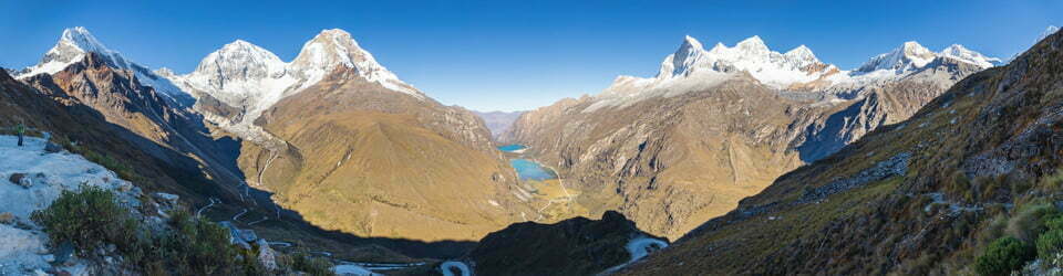
View towards Ellensbrook from just south of Cowaramup Point
We enjoyed clifftop walking with sweeping coastal views and of course more soft sand walking before we reached Ellenbrook House. The Meekadarabee Falls had very little water flowing over them and our hopes for a swim were again dashed. It was good to reach camp early at 2:30pm as the heat had increased as the day went on. We relaxed in camp for the afternoon deciding where to go from this point as we are both suffering from sore feet and Steve has blisters on both feet.
Day 3 on Western Australia’s Cape to Cape Trail from Moses Campsite to Ellensbrook Campsite
After dark we went to the creek to try to work out all the strange sounds. We saw what appeared to be glow worms. It sounded like there were frogs in the trees.
Day 4: Tuesday 7/11/2017 Ellensbrook Campsite – Margaret River
Max elevation: 71 m
Total climbing: 399 m
Total descent: -344 m
Average speed: 3.89 km/h
Total time: 04:40:51
We didn’t manage to get a particularly early start and the heat was already rising early in the morning. We continued along the C2C track heading towards the mouth of the Margaret River. As always there were gorgeous coastal views. We passed a patch of petrified trees and later Steve managed to photograph an osprey in flight at Cape Mentelle. Here Sue just couldn’t resist the aquamarine water and went for a dip in the picture perfect setting.

Western Osprey (Pandion haliaetus) at The Box, near Cape Mentelle
Day 4 on Western Australia’s Cape to Cape Trail from Ellensbrook Campsite to Margaret River
Another check of the weather forecast had the next two days topping 30 degrees again, along with possible thunderstorms. As we do this for pleasure we decided to end our trip at Margaret River and organise a hire car earlier than booked so that we could drive to the lower section of the area to do sections of the C2C as day walks. Accommodation for the night was also quickly organised over the phone. Now we just had to get to Margaret River!
Soon we could see the mouth of the river and realised we would need to take our shoes off. Today the crossing was relatively easy, with the water slow flowing and only up to thigh height. Once we reached the road it was really getting hot so we tried to hitch. This was initially unsuccessful, possibly because we hadn’t showered for four days. Soon a kind local gave us a ride to the car hire company and our car was ready to go!
In a way it was sad to finish early but the heat really got the better of us. As the temperature continued to rise as the afternoon went on we realised we made the right decision. [News reports later indicated the South West Corner had experienced an extended period of high temperatures for this time of year, averaging 8 degrees above normal, beyond anything experienced in 120 years of temperature records]
References: The Cape to Cape Track Guidebook, Jane Scott 2015. A very comprehensive guidebook with detailed topographic maps and information on locations, flora and fauna. Highly recommended.
Clickable icons on a world map which open the related trip report
A detailed, searchable trip list with links to reports, photo galleries and other content
![]()