
29/09/2017 – 4/10/2017 Guthega – Pounds Creek – Twynam Creek – Mount Anton – Mount Twynam – Watsons Crags – Mount Anderson
Kosciuszko National Park, NSW
Ngarigo country
Distance: 86km Total Ascent: 4640m Total Descent: 4640m
Time: 39 hours Track Info
Participants: Damien Aggio, Stephen Davies (Photos, Report), Murray Gibbs
Despite a forecast for wind and clouds on Saturday early next week looks calm. My objective for this trip was to wait for the calm weather then move camp to the top of a high point with great views that would work well for star trails and time lapses. Several similar trips over the last few years have yielded some good results.
Day 1: Friday 29/09/2017 Guthega – Pounds Creek
Max elevation: 1988 m
Total climbing: 619 m
Total descent: -441 m
Average speed: 3.48 km/h
Total time: 04:23:40
Departing from home at 6:30am saw me enjoy a good run all the way despite it being a holiday long weekend starting tomorrow. Six speed cameras were passed along the way.
As Damien and Murray left Sydney at 4:30am I was expecting to meet them at our designated campsite on Pounds Creek below Mount Anton.
I left the car at Guthega at 12:30pm. After walking a little past the terminal, skis were on for the short downhill run to the foot-bridge across Farm Creek. The snow was soft, heavy and wet. I was surprised to see 30m of grass had appeared just over the bridge since I skied out last Saturday. Amazing what warm temperatures and wind can remove. With skins on good progress was made through the trees above the Snowy River. A few bar patches needed to be detoured around. Skis off again to cross Illawong swing-bridge before heading uphill.

Ski tracks along Snowy River beyond Blue Cow Creek
It wasn’t a couple of hundred metres before I had caught up with Damien and Murray. Ski hire and a lunch stop had put our arrival times only half an hour apart.
Climbed gradually to the left of Pounds Creek, purposely avoiding getting too close at around 1700m where the valley becomes narrow and steep. Soft slow slow was the order of the day. The ridge before our campsite had a couple of stretches of grass to be negotiated. The ridge on the other side of Pounds Creek had large areas of grass, all exposed during the last week.
After setting up camp about 20m from where we thought the creek flowed, we headed upstream to look for an open water source. After checking a couple of spots a good walk down on rock and grass opening about 100m from our camp was put to good use.
A few puffs of wind and overcast conditions with a few sago showers saw out the last of daylight.
Day 2: Saturday 30/09/2017 Pounds Creek – Twynam Creek – Snowy River
Max elevation: 2181 m
Total climbing: 1034 m
Total descent: -1045 m
Average speed: 5.07 km/h
Total time: 04:07:03
A cold and windy night continued on throughout the morning. With the cloud base somewhere below us we had no desire to leave the comfort of our tents. Our increasing desire to get out corresponded to a slight lifting of the cloud base and the intermittent appearance of small patches of blue sky.
After an early lunch enjoyed in the sheltered warmth of our tents Damien and I headed off up Pounds Creek towards its source. This option wasn’t attractive to Murray so he pursued an exploration of the area around our campsite. As Damien and I continued upstream we questioned our decision as we were skiing across a rock hard surface and being periodically hit by 80km/h wind gusts laden with sago. This was painful on every inch of exposed flesh. After reaching the bowl below Mount Twynam I was inclined to return to camp. Damien, however, had a more positive spin on our options so we headed towards Twynam Creek. After negotiating our way along a snow drift through the grassy ridge below the bowl we sidled around a way into upper Twynam Creek before starting our descent.
After dropping above 100m vertically the hard surface had already given way to breakable crust and a little lower again we were on soft snow. Our destination seemed to change at each stop to take advantage of what we could see ahead. We passed by the campsite I had used last week before heading down on a good telemark run into Pounds Creek. Once at the creek we thought we would try to follow it down to the Snowy River. This proved very interesting as the complete cover from just a week previously had been rapidly breaking up, with three metre plus thick sections of snow slumping into the creek, leaving crevaces and vertical snow banks along the creek. It was really picturesque.

Damien crossing Lower Pounds Creek
Unable to reach the Snowy River by this route due to large outcrops of grass we climbed a little before completing a final downhill run to the Snowy. At this point we both put on our skins on and returned to camp just after 4:00pm. The evening sky produced some really good colour and the wind was easing off and increasing patches, at least for a short time, of blue sky were starting to appear.
Day 3: Sunday 1/10/2017 Mount Anton Saddle – Mount Twynam North Ridge
Max elevation: 2290 m
Total climbing: 1396 m
Total descent: -1330 m
Average speed: 5.76 km/h
Total time: 07:54:22
Fog and a light breeze greeted the morning. After some deliberation we decided to head over to the western side of the Main Range and try for Watsons Crags. Also, now that the wind was forecast to drop off we also planned to move camp to the top of the range in order to catch both sunset and sunrise and maybe some time lapses over the next few nights.
I managed a couple of short runs above camp before Damien and Murray were ready. After filling all available water containers Murray and I carried this up to our new campsite in preparation for our move.
The warm daytime temperatures and ample wind of the last week have removed a lot of cover on and near the western faces of the ridges. As a result we found ourselves taking a circuitous route with numerous small detours taking in the awesome views on this of the range.
At one point we noted the fantastic cover on the north ridge of Mount Twynam. So we took a great run down into the creek on its eastern side and had lunch by the creek where there was a little protective from the cool breeze.

Climbing the northern ridge of Mount Twynam with Mount Anderson “West” behind
After our short break we climbed 310m vertically along the ridge (not even to the top). Our ski down this fantastic slope was turned out to be our best run of the season to date. Lots and lots of turns on, until the last 40m, very consistent and easy spring snow. By the bottom it became very heavy and slow. Another 310m saw us back near the top, where being 3:00pm, we opted to head back to camp. We sidled around and crossed the range just to the south of Mount Anton. From here we enjoyed another fantastic run back to camp.
We made quick work of packing and moving up onto the ridge. Making it in time to re-establish camp, prepare dinner and have a hot soup before setting up a “Holy Grail” time lapse hopefully catching the sunset colours and onto star trails. With the moon at 60% there wasn’t going to be the usual rich tapestry of stars that can be captured from here. The light breeze blowing in the evening did, however, fade away, resulting in condensation on my lens – giving a very soft focus result at the end of the sequence.

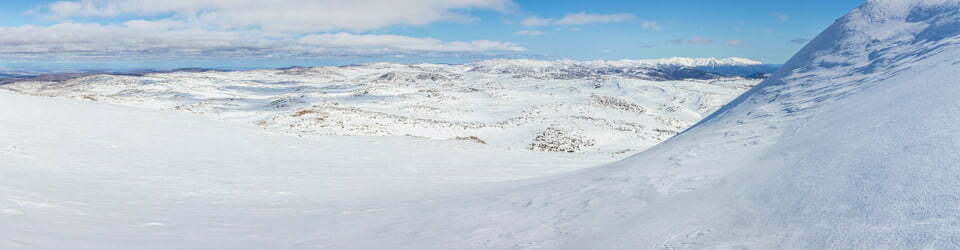
High camp on saddle between Mount Anton and Mount Anderson
Day 4: Monday 2/10/2017 Mount Anton Saddle – Mount Anderson North Ridge – Mount Anton
Max elevation: 2012 m
Total climbing: 1065 m
Total descent: -1066 m
Average speed: 5.54 km/h
Total time: 06:57:13
Blue skies with a cool, gentle breeze about the peaks was the order of the day. The usual wait for the overnight freeze of the snow surface to soften gave us a couple of hours to linger and enjoy the views before we headed off towards Mount Anderson in the north. Great views all around saw many photos taken before we descended off its eastern face down into an upper tributary of Three Rocks Creek with Mann Bluff on the next ridge. This was such a great run, despite at times poor traction in soft snow on the ascents, we all did it twice.

Telemark tracks off Mount Anderson “West”
Lunch on rocks next to the creek was followed by an ascent up the creek to the saddle formed with Pounds Creek on the other side. From here we returned to camp where Damien and Murray packed up before heading back to Guthega, their long week nearly over. I completed a water collecting run with a extension up to the summit of Mount Anton. Being a water run I didn’t have my camera with but the views from here are truely superb in all directions, particularly towards Watsons Crags and the west. I really need to aim to camp on top at some stage and take in the dawn, dusk and night skies.

Sunset over Watsons Crags
Day 5: Tuesday 3/10/2017 Mount Anton Saddle – Watsons Crags
Max elevation: 2199 m
Total climbing: 1343 m
Total descent: -1336 m
Average speed: 5.86 km/h
Total time: 07:08:25
A cool and breezy morning as forecast. With clear skies a trip to Watsons Crags seemed like a good idea. So after giving the overnight freeze a chance to thaw I had a short descent into Pounds Creek. This had the advantage of offering some shelter from the breeze and providing a long gradual climb to the base of Mount Twynam.
Timing was good as my 11:00am ascent of Twynam had allowed the snow to soften enough for the skins to grip well – so rapid progress possible. There remained a thin veneer of ice across large areas, with the wind occasionally freeing small pieces and sending them flying across and over the surface, tinkling as they bounced.

Mount Twynam from Pounds Creek
From the summit a fast descent saw me over to Watsons Crags. Here I took my time skiing its length, with lots of small detours to catch the views from a variety of vantage points. On reaching the Crags the breeze had disappeared ,making it very pleasant at least until it reappeared late in the afternoon.
Lunch was enjoyed at a very scenic vantage point near the western end of the Crags before I started the return leg. A couple of excellent telemark runs were enjoyed just before leaving the Crags. As it was now just past 3:00pm it was time to move on.

Telemark tracks on Watsons Crags
After re-summiting Mount Twynam a long telemark run back down into Pounds Creek via Little Twynam saddle was enjoyed, even though the snow became heavy towards the bottom. The return down Pounds Creek was quick but limited in turns due to the heavy snow. I wasn’t back to camp until just after 5:00pm.
After fortifying all of my tent pegs with piles of snow 30cm high prior to departure, it was interesting to observe this had just been enough. Almost all the piles had sublimated away in the windy and full sun conditions. One vital peg had very little left holding it in place.
Another evening with colourful evening skies under a nearly full moon.
Day 6: Wednesday 4/10/2017 Mount Anton Saddle – Mount Anderson West Ridge – Mount Anton
Max elevation: 1950 m
Total climbing: 1285 m
Total descent: -1532 m
Average speed: 6.65 km/h
Total time: 08:53:02
A blue sky day with next to no wind! I can’t leave this morning as planned, need to make the most of this weather.
I ventured over to the western side of Mount Anderson having observed very promising looking slopes from afar on previous days. The ski across to the saddle between Mount Anderson and the knoll to it’s west was completed before it had thawed. However, once on the north facing Verandah Creek side there was perfect spring snow, so four fantastic telemark runs were completed between the saddle and creek. From here I headed up onto the knoll for an explore. There are some really interesting looking granite tors on top of this knoll and brilliant views, especially towards the Grey Mare Range and Jagungal as well as Watsons Crags to the south. A great spot for lunch.

Jagungal from Mount Anderson “West”
From “Anderson” knoll I headed south towards Watsons Creek. The snow was now ideal so three more runs were enjoyed. Now being 3:00pm it was time to return to camp, pack up and leave. Departing by 4.30pm I descended back into Pounds Creek before following it briefly to the east, sidling around the tree covered ridge where the creek does a sharp right hand turn before reaching more open terrain above Illawong bridge. This was completed in about 30 minutes.
The traverse back to Guthega, however, took much longer. A heavy pack and need to keep skins on skis, manoeuvring up and down to get around clumps of trees and grassy patches. Needless to say I was very happy to see the car just as the sun was dropping below the mountains.
An awesome days skiing but with a lot of effort put in followed by an overnight camp at Island Bend before heading home.
Clickable icons on a world map which open the related trip report
A detailed, searchable trip list with links to reports, photo galleries and other content
![]()