
14/07/2017 – 19/07/2017 Gran Paradiso
Gran Paradiso National Park, ITALY
Distance: 97km Total Ascent: 5,520m Total Descent: 4,800m
Time: 35 hours
Participants: Jenny Asquith, Hannah Brody, Mel Brody, Paul Brody, Stephen Davies (Photos), Sue Davies (report), Erica Fantini (Guide), Karen Laverack, Simon Marlton
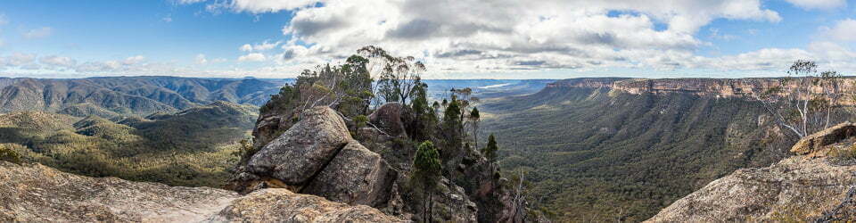
Gran Paradiso is Italy’s oldest national park. It includes numerous soaring peaks, massifs, glaciers, interconnected ridges and cols separated by deep tranquil valleys and rushing streams. Within the park the 4061m Gran Paradiso is the dominant peak but there are also sweeping panoramas beyond towards the Matterhorn, Mont Blanc and Monte Rosa. Closer up one an observe alpine meadows and ice-smoothed rock faces. We observed chamois, ibex and alpine marmots and many wildflowers.
Throughout the area there are many different signposted walking trails. Here we participated in our first ever guided walk, as we had decided to join a group of friends to explore this area of Alpine Italy.
Day 1 Friday 14/07/2017 Chardonney – Rifugio Miserin
Max elevation: 3628 m
Total climbing: 1216 m
Total descent: -162 m
Average speed: 5.08 km/h
Total time: 05:30:06
We were transported by mini bus from our accommodation in Settimo Vittone to the start of the walk at Chardonney. We had been concerned about the heat as the previous night when we arrived at Settimo Vittone it was very hot. The difference in starting at an altitude of 1500m and having a cool breeze soon allayed our concern.
I had not realised that this trip involved several days of walking on the Alta Via 2. So it was quite reminiscent of the AV1 (which we had completed several years previosly) as we began crossing farmland with cows on the trail and its proximity in places to roads.

Hiking along Torrente Ayasse
We climbed steadily but fortunately the grade was fairly gentle. We passed interesting old stone farm houses with slate roofs that were not fixed but had remained in place due to tile’s own weight. Our guide provided information on which plants were edible and the ones that can kill you! The weather was clear and sunny.
Our walking track eventually morphed into a gravel road which continued the gradual climbing until we reached the lakeside Rifugio Miserin. Here we spent some time relaxing in the afternoon sunshine. Next to the Rifugio was a chapel, apparently built in celebration of the locals surviving the plague.
Unfortunately, huge high voltage power lines dominated the valley and limited our options for really good photos. After settling in Sue and Steve went for a walk around the lake where we enjoyed the tranquility of a bubbling brook which fed the lake. Rifugio Miserin has rather limited space in the bunk rooms. We had never seen beds crammed so closely together. There was only space for one person to pass around the beds at any time. Despite this we had a good night’s sleep.
Day 2 Saturday 15/07/2017 Rifugio Miserin – Finestra di Champorcher – Lillaz
Max elevation: 3859 m
Total climbing: 696 m
Total descent: -1599 m
Average speed: 4.13 km/h
Total time: 08:04:07
We all agreed to get an early start so we headed off just after 8:00am. We had a relatively short up climb to Finestra di Champorcher. Near the col the wind was very cool with many of us needing to wear gloves. The transmission lines went right over Finestra di Champorcher with us and down into the next valley. For us they really seemed to dominate the landscape. We found it very surprising that this route through the National Park was chosen for the distribution of energy.

Jenny, Karen, Hannah, Paul, Mel, Sue, Simon and Jenny on Torrent d’Urtier crossing
We had a gentle descent from the Col and managed to spot some marmots dashing for their burrows as we approached. We also heard their calls.
We continued to descend below the tree line so we were back into forest with some waterfalls. The gradual descent was fairly slow and steady until we finally reached the charming town of Lillaz where we had booked hotel accommodation for the night.
We had another great multi course dinner. We could see Mount Blanc from our balcony which was 40km away.
Day 3 Sunday 16/07/2017 Valnontey – Rifugio Vittorio Sella
Max elevation: 2543 m
Total climbing: 944 m
Total descent: -67 m
Average speed: 4.03 km/h
Total time: 02:59:52
From Lillaz we caught a bus to Colgne, which is a delightful small town. We had an hour to shop for lunch supplies and have a look around.
We then caught a second bus to the start of the trail at Valnontey. It was a another gradual ascent with the scenery opening up as we climbed. We had great views of the Gran Paradiso range and glaciers.

Alpine marmot near Laghetto del Lauson
Afternoon walk around Laghetto del Lauson
Max elevation: 2660 m
Total climbing: 636 m
Total descent: -634 m
Average speed: 3.40 km/h
Total time: 04:34:21
After several hours we arrived at the scenically positioned Rifugio Vittorio Sella (as most Italian Rifugios are). Here we had an enjoyable lunch in the sunshine. During the afternoon we walked around to Laghetto del Lauson and further around the ridge for a closer view of the glaciers. On the way back we saw chamois up close along with their young, as well as some alpine marmots.
Day 4 Monday 17/07/2017 Rifugio Vittorio Sella – Col Lauson – Eaux Rousse
Max elevation: 3265 m
Total climbing: 944 m
Total descent: -1800 m
Average speed: 3.89 km/h
Total time: 08:01:41
We decided on an early start as we knew we had a long day. Breakfast was on offer early and consisted of delicious home made wholemeal bread, muesli and home made yogurt! We were out on the trail before 7:30am.
Our progress towards the pass was delayed by the presence of Ibex and Steve needing to get out his long lens. At one stage Steve was so focused on photos he left his trekking pole behind. There would have been far worse places to wait, sitting in the sunshine, surrounded by mountains and bubbling streams.

Alpine Ibex (Capra ibex)
Then on to Col Lauson. The mist in the valley was rising and looked quite spectacular. The final climb to the pass involved some narrow paths with some exposure along with a short roped section. All our party members managed really well, especially the two who felt extremely uncomfortable with the exposure. Steve was behind taking photos as usual and Erica called out “Steve, the Japanese are coming!” referring to a large group coming up behind us. After a lookout break at Col Lauson we faced the big descent, 1800m in total!

Approaching Col Lauson
As we descended from the Col the valley was thick with mist. Incredibly, as we descended further, it started to dissipate to the point that when we were halfway down we had gained clear views. We were extremely lucky with the weather to this point as we continued to be bathed in sunshine. Being very long and gradual the descent seemed to be never ending. We finally arrived at our hotel where all parties made the most of the wifi, exchanging photos from the day with the outside world. Eaux Rousse was a collection of houses rather than a town and our hotel was a fantastic labyrinth of rooms which featured a lot of historical memorabilia, it was part museum really.
We enjoyed a wonderful and well deserved four course meal that night including chestnut flour pasta with deer, trout with orange sauce and raspberry semi freddo. So good!
Day 5: Tuesday 18/07/2017 Eaux Rousse – Rifugio Savoie – Col Nivolet
Max elevation: 2556 m
Total climbing: 738 m
Total descent: -186 m
Average speed: 4.08 km/h
Total time: 03:26:20
We were enjoying a fantastic breakfast (at Eaux Rousse) including wholemeal apple strudel (and who says you can’t have that for breakfast?) when we realised we had to catch a bus in ten minutes. So it was a very quick pack up before rushing out the door!
The short bus trip dropped us off at the trailhead in Le Breuil where there was also a market to buy food for lunch. We started on the trail at about 9:30am and began climbing quickly. There was some mist around the peaks but we were able to see some climbers of in the distance attempting the summit of Gran Paradiso.

View back down along Nivolet valley from Nivolet
From here we walked south-west up through the Nivolet valley where our friends the power transmission lines had rejoined us. We continued to walk along the valley until we reached Rifugio Savole for lunch. Certainly not the best Rifugio we had ever stayed in, with it’s facilities somewhat rundown. For example the communal shower screen was broken and leaning back into the shower recess.
During the afternoon we walked past several lakes up to Col Nivolet. From here looking to the south there are great views to and beyond Lago Agnel, including the road down which we would likely cycle tomorrow. Whilst on the Col the mist descended over the peaks so we soon retreated into the Rifugio near the Col for coffee and cake before relaxing for a few hours before dinner. No wifi or phone service was available at the Rifugio but there was good phone signal at Col Nivolet.
Day 6: Wednesday 19/07/2017 Rifugio Savoie – Villa
Our morning walk around Lago Rosset
Max elevation: 2763 m
Total climbing: 347 m
Total descent: -350 m
Average speed: 3.43 km/h
Total time: 02:29:24
At Erica’s suggestion we agreed to ride hire bikes for the long descent to Villa as she suggested it was long and not that interesting on foot. This allowed us time to explore the lovely alpine scenery above Rifugio Savole instead, all without the encumbrance of full backpacks.
We set off after breakfast, soon climbing past a farm with lots of cows leaving the barn for the day. A little further along there were great views of Lago Rossett and surrounding mountains, all under clear sunny skies, and best of all we had it all to ourselves!

Returning to Lago Rosset
After reaching the high point Simon announced that he wanted to say something. He thanked Erica for her guidance over the past week and Jenny for organising the trip. He then gave a heartfelt speech proclaiming his love and adoration for Jenny. Such was the sincerity of the message there wasn’t a dry eye around. Our Italian guide Erica exclaiming “Mumma Mia!” At this stage Steve and Paul were feeling woefully inadequate but we all knew they felt the same for their wives. There couldn’t have been a better place for such a wonderful event and we carried that experience with us for the rest of the walk.
On the way back Jenny, Simon and Paul were all brave enough for a swim in Lago Rosset while the rest of us walked on.
Our bikes arrived with at 11:00am. They were replaced on the truck with our backpacks which were to taken down to Villa where we would catch bus to return to Settimo Vittone.
Our bike ride from Rifugio Savole to Villa
Max elevation: 2615 m
Total climbing: 754 m
Total descent: -1704 m
Average speed: 17.99 km/h
Total time: 02:13:54
Now on bikes we first we needed to climb the hill up to Col Nivolet. There was quite a bit of huffing and puffing along the way but we all finally made it. There were good views of Lago Serru and Lago Agnel with some mist obscuring the high peaks. Then down we went. It was a long descent , we were so glad we were on bikes!
There was not much traffic which was good. The pace was very relaxed with frequent stops. We had a few spots of rain in the final five minutes of the ride. Before long we were down and having lunch in the restaurant at Villa celebrating the completion of our adventure with tiramisu. The heavens opened whilst we were there, we could not believe how fortunate we had been with the weather.
The transfer bus picked us up at 3:00pm for the return to Settimo Vittone. Once there we had a very comfortable evening again with an extensive selection of fantastic home-made food.
We all agreed we had a great walk and we had been blessed with perfect weather.
In summary, I feel the best days were 3, 4 and 6. I was not keen on the power lines. The food was very good apart from the standard very basic Rifugio breakfasts.
Clickable icons on a world map which open the related trip report
A detailed, searchable trip list with links to reports, photo galleries and other content
![]()