
23/04/2017 – 25/04/2017 Long Gully – Byangee Mountain return
Morton National Park, NSW
Yuin country
Distance: 29km Total Ascent: 1400m Total Descent: 1400m Time: 10 hours
Participants: Beth Davies, Stephen Davies (Photos), Sue Davies (Report), Cristina O’Gorman, Darren Masey
The old folks (Steve and Sue) took the young ones (Beth, Cristina and Darren) on an overnight adventure, including Cristina who had never been camping before. We arrived at Long Gully campground on Sunday afternoon and set up camp ahead of the young ones who arrived to the luxury of tents erected, sleeping bags out and dinner ready. The campground was the most crowded we had seen it as after all it was a long weekend. After the day trippers left, however, we had a peaceful evening and enjoyed a campfire on a clear calm warm evening.
Day 1: Monday 24/04/2017 Long Gully campground – Byangee Mountain
Max elevation: 547 m
Total climbing: 1138 m
Total descent: -672 m
Average speed: 4.22 km/h
Total time: 07:24:53
We awoke to a light misty morning which soon turned into a warm sunny day. We made good progress up the “Castle Ridge” ramp trail whence at the top Steve decided to climb up for a better view at the “rock face”. The rest of the group soon followed. We enjoyed some classic Budawang views which Darren and Cristina particularly enjoyed as they hadn’t been to the area before. There were more than a few selfie shots taken during the day!
We followed the base of the cliffs along The Castle but missed the fern gully (Cathedral Cave) as the rock cairn I recalled had been removed. We had an early lunch at the arch enjoying the warm April weather as we did. We could have lingered longer but we decided to head off to enjoy the afternoon on top of Byangee Mountain.

Christina, Darren, Bethany and Sue under the Arch with nearby Byangee Mountain
We made quick time across the saddle and we were soon walking along the cliffs below Byangee Mountain. A decaying dead wallaby next to our route quickly got our attention, the smell was quite overwhelming! We soon reached the gully for our ascent, noticing there was another tree down, partly blocking our path, since we last walked this route. This large fallen tree was making the first part of our scramble up a little more interesting. Cristina was getting a crash course in scrambling and climbing techniques from Steve which I’m sure she found helpful. She managed very well considering she had no prior experience. We were all pleased to arrive to the top around 2:00pm but were a little concerned when we discovered there was no water in the usual spots. On several previous trips we had always managed to find a number of pools of water in depressions on the rocks but this time they were all completely dry!
After considering the options, Steve and Sue decided to hike back to a large pool that was halfway along the cliffs below The Castle. We took all the available empty water bottles and left the young ones to enjoy the afternoon sun, heading off at about 3:00pm.
Steve descended at a hectic pace and we reached the pool, 3km away over quite rough ground in just 50minutes. We filled our containers and lugged 14litres of water in our packs back up the mountain, the round trip taking us two hours. The young ones had enjoyed the afternoon, taking photos, collecting firewood and finishing the camp set up. We still had time to enjoy the sunset, prepare dinner and take some more pictures. We were all pretty exhausted by 9:00pm and turned in for the night.
Day 2: Tuesday 25/04/2017 Byangee Mountain – Long Gully campground
Max elevation: 534 m
Total climbing: 282 m
Total descent: -688 m
Average speed: 5.08 km/h
Total time: 02:45:19
It was an impressive sunrise and what a fantastic spot to enjoy it! Unfortunately the wind had started to pick up soon after and a check of the weather radar indicated that the rain was likely to be falling on us within the next thirty minutes! With that motivation we packed up camp very quickly and started our descent before 8:00am.

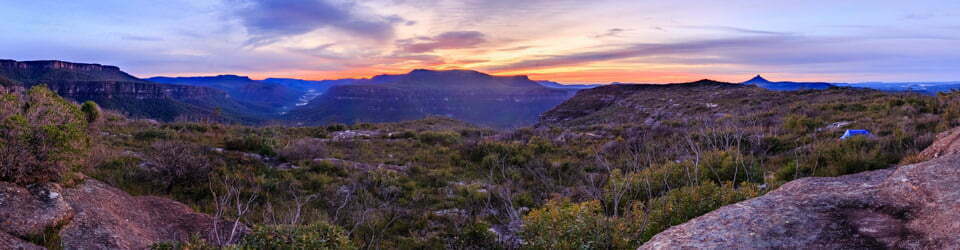
Pigeon House Mounatin from our campsite on Byangee Mountain
We made good progress and other than a few spots of rain the weather was not the problem expected. We stopped at “Cathedral Cave” fern gully on the way down but almost missed it again.
Steve and Sue enjoyed a dip in the river at the Long Gully campground which was refreshing after the walk. We were early enough to enjoy lunch at the Heritage Bakery in Milton where we parted ways.
We have done this trip a number of times now and it is always enjoyable. It has to be one of the most scenic places in the area to camp with wonderful 360 degree views taking in Pigeon House Mountain, The Castle and Mount Talaterang amongst many other less prominent features.
Clickable icons on a world map which open the related trip report
A detailed, searchable trip list with links to reports, photo galleries and other content
![]()
With thanks! Valuable information!
This is a impressive story. Thanks!
I got what you mean,saved to fav, very decent site.
With thanks! Valuable information!
Hello. impressive job. I did not anticipate this.
This is Jerringa country, not Yuin country.
https://newbushtelegraph.org.au/the-jerrinja-tribe-and-the-shoalhaven/
This is Jerringa country, not Yuin country.
https://newbushtelegraph.org.au/the-jerrinja-tribe-and-the-shoalhaven/
We also found no pools on top of Byangee on our trip earlier this year, however the creek near the ascent was flowing well and there was also water in Cathedral Cave. You mention hiking back to a large pool to get water… Whereabouts was this?
I may have exaggerated a little calling it a large pool. It is partially behind a large fallen rock slab about half way between Cathedral Cave and Castle Gap against the cliffline and is sustained by water dripping off The Castle itself.