
23/02/2015 – 26/02/2015 Whakapapa Village – Waihohonu Hut – Oturere Hut – Mount Ngauruhoe Summit – Mangatepopo Hut – Mangatepopo Hut – Whakapapa
Mount Ngauruhoe Circuit, NEW ZEALAND
Distance: 57.7km Total Ascent: 2760m Total Descent: 2760m Time: 21 hours 30 minutes
Participants: Stephen Davies (Photos), Sue Davies (Leader, Report)
“Three fabulous nights and four glorious days” Lisa from Melbourne
Day 1: Monday 23/2/2015 Whakapapa village – Waihohonu Hut
Max elevation: 1352 m
Total climbing: 567 m
Total descent: -582 m
Average speed: 4.78 km/h
Total time: 04:43:16
We started out from Whakapapa (pronounced fukapapa) village under overcast skies. We left our car in the car park in the main street hopeful that we would return to it intact in four days time.
We found the start of our trail (others didn’t and wasted a few hours as there are two entry points so it is not truly a circuit). It was easy walking along an even path and we set a good pace in the cool conditions.
We stopped for a photo opportunity at the Taranaki falls. We set off as a large group of school students approached. We took the short detour to lower Tama lake, an old explosion crater.

Taranaki Falls
We made good time and reached the plush Waihohonu hut in an hour less than the estimated time. We relaxed at the hut, happy to find only a few walkers there. We walked to the nearby springs which was the recommended water source. It was a lovely afternoon and many people had a swim in the crystal clear waters.
Back at the hut our peace was disturbed when a group of 17 walkers arrived late and filled the bunk room. Their antics included an impromptu circus oz performance and getting the giggles in the bunk room well after bed time.
Day 2: Tuesday 24/2/2015 Waihohonu Hut – Oturere Hut
Max elevation: 1381 m
Total climbing: 694 m
Total descent: -403 m
Average speed: 4.18 km/h
Total time: 05:20:31
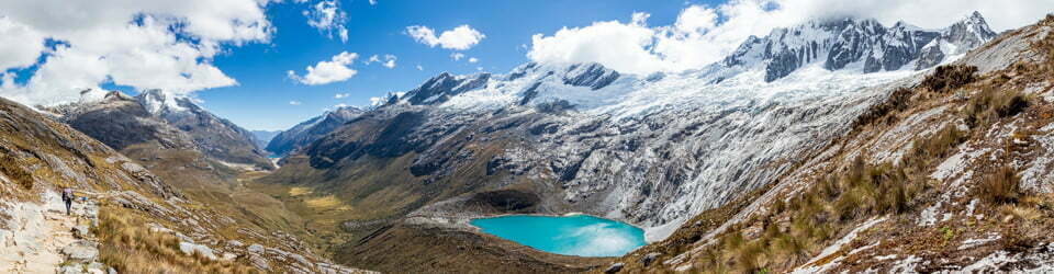
Today was an easy day, just a three hour walk to Oturere hut. We had good views of Ngauruhoe for most of the day. We met up with the two Lisa’s from Melbourne who were walking the route in the same direction as us and laughed about the antics in the hut the previous night. We arrived at the hut for lunch and relaxed in the afternoon, meeting other walkers from around the world as the small hut filled up as the evening progressed. We planned and prepared for an early departure to make the most of our “crossing” day.

Mt Ngauruhoe from the end of the Oturere Valley
Day 3: Wednesday 25/2/2015 Oturere Hut – Mt Ngauruhoe Summit – Mangatepopo Hut
Max elevation: 2274 m
Total climbing: 1273 m
Total descent: -1430 m
Average speed: 3.52 km/h
Total time: 09:06:26
We awoke at 5.30am and started walking by 6.00am without even a cup of tea. We were walking in the “wrong” direction against the flow of people walking the Tongariro Alpine crossing. This day walk is the most popular in New Zealand and gets up to 3000 people walking the 19 km route each day! We had been warned that we would have a constant barrage of people and that it was very steep walking up to Emerald lakes. Even the hut warden told us we were leaving too early as we would miss the Oturere valley.
We started out with our head torches (Steve’s died after a few minutes). We only needed the torches for the first thirty minutes and then we had the beautiful pre dawn light in the valley on a very clear morning.

Emerald Lake
In the valley we had fantastic views of the crater and the lava flows as the sun rose. There was not another person around. It was gorgeous! We reached the emerald lakes and took our photos without any people in them which would be quite rare. As the morning sun rose mist filled the valley and gradually people started coming as we reached the top of the red crater (the highest point on the circuit). Many of these people seemed ill prepared for walking, having inadequate clothing, fitness and over sharing of loud music.
We left the throngs to climb to the top of Ngauruhoe summit, a side trip of three hours. It looked a long way up! We’d been given the advice to climb up on the lava flows and down the loose scree and sand material. It was still hard going. Almost one step forward two steps back. The mist followed us making the scenery quite eerie. After two hours of hard work, the last section of red scoria being the most difficult, we reached the crater rim. Unfortunately the mist obscured most of the views but we did get to see inside the massive crater with unusual graffiti at the bottom of the crater.

Sue on the rim of Mt Ngauruhoe crater
It was time to go down. This was not an easy task for some. The scoria, sand and loose rock constantly gave way beneath your feet. Sue arrived at the bottom somewhat battered and bruised.

Sue descending Mt Ngauruhoe on very loose scoria
By the time we rejoined the main track nearly all the day trippers has passed so it was really a lovely and peaceful walk back to the Mangatepopo hut. We arrived there at 3:30pm, tired, in need of a cup of coffee and food but satisfied with our effort of walking 17km with a pack and climbing over 1300 vertical metres. It had been a good day.
The hut was less busy and we enjoyed the evening except for a lively group of students who were camping and were a little over excited after a big day.
Day 4: Thursday 26/2/2015 Mangatepopo Hut – Whakapapa
Max elevation: 1202 m
Total climbing: 289 m
Total descent: -361 m
Average speed: 4.51 km/h
Total time: 02:25:09
We had an easy three hour walk back to Whakapapa. The track was very rough due to erosion and it was easy to see why the time estimated is five hours if the weather is bad. We said our good byes to the two Lisa’s only to meet them again in the car park. They were keen to hit the hot springs. We had lunch at the cafe at the Chateau Tongariro and reflected on our fantastic walk. We felt for us it had worked out better to walk the route the way we did as we saw the most impressive features of the walk without other people and we were really lucky to get a crystal clear morning on our “crossing” day.
Clickable icons on a world map which open the related trip report
A detailed, searchable trip list with links to reports, photo galleries and other content
![]()