
5/05/2012 – 6/05/2012 Long Gully – The Castle – Monolith Valley
Morton National Park, NSW
Yuin country
Participants: Stephen Davies (Leader), Sue Davies, Helen Crom, Dave Whitelaw (Report), Fred Zicker.
I hadn’t been into Monolith Valley since the eighties and was keen on seeing its marvellous sandstone features again. An earlier departure from Wollongong on Friday than normal, allowed for an al fresco dinner at our start point on Long Gully Rd. We were snug in our sleeping bags by the time Fred arrived.
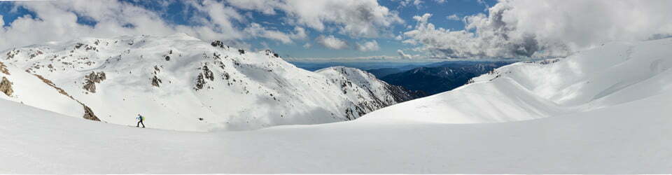
Day 1: Saturday 5/05/2012 Long Gully – The Castle – Cooyoyo campsite
This route was reconstructed from memory using Google Earth Pro and GPS Visualizer.
Max elevation: 832 m
Total climbing: 1020 m
Total descent: -543 m
Average speed: nan km/h
Wonderful autumn weather ensued for the next two days. A 3 hour walk up Kalianna Ridge had us at Cooyoyo campsite below the Castle for lunch. We set up tents then, to make it easier on our return from climbing the Castle, taking head torches just in case of lateness. We were to have the place to ourselves as it turned out.. Travelling lightly we made good time to the top despite a few tricky bits. Once we’d taken our photos of the iconic 360 degree views, it was decided we didn’t have enough time to do much exploring on top. However the bonus was more time to enjoy the pleasures of camp in daylight.
Day 2: Sunday 6/05/2012 Cooyoyo campsite – Long Gully
This route was reconstructed from memory using Google Earth Pro and GPS Visualizer.
Max elevation: 795 m
Total climbing: 661 m
Total descent: -1134 m
Average speed: nan km/h
The walk into Monolith Valley the next morning with daypacks was via Nibelung Pass, a well marked track. Following the track between Mt Cole and Seven Gods Pinnacles, we stopped for lunch at the north end of the latter. Great views were to be had of the surrounding sandstone formations. On our return we stopped at the Natural Arch above us on the west side. Not having daylight saving meant limited time for much else, unfortunately. A rapid 2.5 hour downhill return (we’d left our packs at the saddle) had me, at least, warm and thirsty from the afternoon sun. Steve and Fred stayed the night in order in order to see sunrise from Pigeon House the next morning. However a headtorch walk before dawn wasn’t on my agenda right then !
An envigorating and satisfyingly tiring weekend meant we were looking forward to another trip there, but allowing for more time to explore.
Clickable icons on a world map which open the related trip report
A detailed, searchable trip list with links to reports, photo galleries and other content
![]()