
Thursday 23/02/2023 Tulloch Ard Lookout Walk – Snowy River Lookout
Snowy River National Park, VICTORIA
Gunaikurnai Country
Participants: Stephen Davies (Photos, Report), Sue Davies
The purpose of our multi-day adventure along the Barry Way was to explore the area and complete a few interesting walks if we could find them. On this occasion, it was a signpost on the main road to Tulloch Ard Lookout Walk. We took the turn, finding ourselves driving through some local farms to gain access to Snowy Mountains National Park. Once in the national park the grasslands of the farms gave way to forest and the road became narrower before we reached the start of the walk.
Max elevation: 753 m
Total climbing: 217 m
Total descent: -216 m
Average speed: 5.49 km/h
Total time: 01:20:19
As it was now very hot, we took our time along the narrow trail. With the area having been logged many years previously all the best of the old growth was now long gone. It appeared to have been some time since the last good rain as the area seemed really dried out.

Views along Tulloch Ard Walking Track
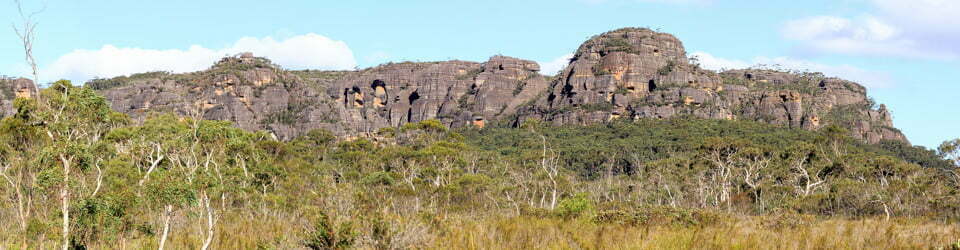
The track itself descends steadily down through the forest until it ends on the edge of a spur, here there is a constructed steel viewing platform from which there are really good views out over the Snowy River valley and the entrance to Tulloch Ard Gorge. Being hot didn’t linger for very long, so after a few photos were on our way on the long climb back to the carpark (a small clearing with room for three or four cars).
There was nobody else around today on the drive or walk, nor did we see any wildlife, we did however hear a Wonga Pigeon on the walk in. It seemed we were the only ones silly enough to be out in the heat today!
Information on National Parks signage along the way
Tulloch Ard Lookout Walk – Snowy River National Park
‘Sunman Njinde’ (Gunnai language) – you are walking on the land of the GunnaiKurnai people ‘Ngooringe’ (Monero language) – you are also walking on the land of the Monero people.
Tulloch Ard Lookout Walk is part of the Snowy River National Park. The park features some of Victoria’s most rugged and remote country. It is a vital link between The Australian Alps and East Gippsland’s forests.
The walk to the lookout will lead you through Damp Forest, Scrubby Dry and Heath Dry Forest types. The lookout provides spectacular views over the Snowy River and the entrance to Tulloch Ard Gorge.
You may also like to try the short walk opposite the giant Mountain Grey Gum. This forest giant is more than 200 years old – a sentinel watching over this wild and rugged place.
National Parks Walk Description
For your safety, please stay on the walking tracks. Steep and unstable cliff edges, make it dangerous to wander off the tracks.
Distance: 1.6km to the lookout
Grade 3: Steep in sections with some steps, not suitable for people with limited mobility
Forest Walk to Tulloch Ard Lookout
If you keep an eye out, you will notice how the forest changes as you near the escarpment and river gorge.
Look around you. In this upper section, the forest is protected from the harsh environment of the Snowy River valley. The damp conditions allow larger trees like Mountain Grey Gums, Messmate Stringybarks and Narrow-leaved Peppermints to thrive, along with bush peas, wattles, tree ferns and vines.
You may also notice several old tree stumps left from past logging operations. The area around Fork Track was logged in the 1970s for Stringybark and Messmate, which are valued for their strong and straight timber.
Down the hill on the rugged valley spurs, exposure to the sun, wind and slope fosters a different community of plants. The tree cover becomes sparser and changes to Red Stringybarks, White Stringybarks and Silvertop Ash with an understorey of plants such as heath, she-oak and dogwood, which can cope with the tougher conditions.
Wildlife thrives here. Wombats, cockatoos, frogs, lyrebirds, Spotted Tailed Quoll and even the rare Long Footed Potoroo live in this wild and rugged country. Look out for the large bluish Wonga Pigeons, which can be seen feeding beneath the native cherry trees along the track.
A living river – from mountains to sea
The Snowy River rises on the south-eastern slopes of Mount Kosciuszko, where it begins a 500km journey to the sea. Along the way, the river drops more than 1700 metres and makes one of the most dramatic and rugged landscapes in Australia.
In its upper reaches, the river winds its way over ancient granitic rocks to form shallow valleys. But the terrain dramatically changes when the river carves through the tough volcanic rocks that poured over this landscape about 300 million years ago. Here, the relentless power of the river cuts, gouges and smashes its way through to create deep gorges, waterfalls and rapids.
Along its way, the Snowy River is joined by several other rivers such as Little River, Suggan Buggan River and Rodger River. These rivers flow sluggishly across the surrounding high plateaus and then suddenly drop off the hard volcanic cliffs, creating their own waterfalls or gorges.
Downstream, the Snowy begins to calm down as it flows through ancient marine sediments, such as the limestone deposits between New Guinea Bend and Buchan. Here its waters have chambers. Eventually, it meanders across the fertile flood-plain around Orbost, broadening out into a network of lakes and wetlands before it finally flows to the sea at Marlo.
The Snowy River has many moods – raging and savage, calm and placid – but always spectacular.
Kissing hills and raging ravines
Getting through the rugged Snowy River landscape has always been a challenge.
GunaiKurnai and Moreno people lived in and moved through this area along established travel routes. They knew the country well and travelled into the surrounding forest areas from base camps along the river. Aboriginal people still maintain their connections to this land, which holds ongoing spiritual significance and contains evidence of their stone masonry workshops, wooden artefacts and implements carved from the trees.
European explorers and settlers first came through this area in the 1830s. They found navigating through the rugged landscape a big challenge, and many were defeated in their attempts.
“I got to a place where the hills are kissing one another… I turned back, I did, twenty times or more” Davey O’Rourke, ca 1850
For many years, the Snowy River was considered impossible to navigate. But in 1937, against all advice, two brave and tough young men named Arthur Hunt and Stanley Hanson set off from Jindabyne in a wooden canoe and headed for Marlo at the entrance to the sea.
“Don’t be a fool… If you go down there, you”ll never come back… Impossible… Madness… Suicide!”
They took two months to complete their adventure-packed journey and became the first of many who now test their skills and luck along this mighty river.
Today, this magnificent wilderness and wild river is renowned for the four-day canoeing/rafting trip from McKillops Bridge to Bailey Hooley. The river is as relentless and dangerous as ever with rapid water level changes, the need for portages around difficult rapids and waterfalls, and due to its sheer remoteness.
Useful – dead or alive
The old Mountain Grey Gum (Eucalyptus cypellocarpa) at the end of this track, whilst fire damaged is showing signs of life almost 2 years after it was burnt.
Dead or alive, old trees provide hollows and prey visibility for wildlife like the Powerful Owl. Whitish scats, and the bones and fur of regurgitated prey (called a pellet) are tell-tale signs of their roost above. Keep a lookout, there’s a good chance you’ll see some around here.
Much of the Australian landscape is in a continual state of change as it recovers from and consolidates after a fire. After several years of drought, 1.1 million hectares of the East Gippsland landscape was affected by the fires of summer 2019-20. This area was only moderately burnt, leaving much of the tree canopy unaffected and patches of bush unburnt. These unburnt patches become a refuge for plants and animals from which to recolonise. Postfire remote camera surveys have captured Long Nosed Potoroos in good numbers. So, whilst at the time all appears lost, recovery sometimes happens fast and sometimes slow but always in ways that remind us how highly adapted the Australian landscape is to fire.
The local flora, fauna, geology, history and some other walks (ChatGPT)
Tulloch Ard Lookout Walk was a place of remarkable natural beauty and history located in the state of Victoria in southeastern Australia. The region was situated within the traditional lands of the Gunaikurnai people, who had lived in the area for thousands of years.
The flora of Tulloch Ard Lookout Walk was diverse and abundant, with towering eucalyptus trees, acacias, and wattles dominating the landscape. The undergrowth was filled with a variety of ferns, grasses, and wildflowers, providing a rich habitat for many species of insects, birds, and mammals.
The fauna of the area was equally impressive, with kangaroos, wallabies, and echidnas grazing in the open meadows and dense forests. The birdlife was also abundant, with a variety of parrots, kookaburras, and birds of prey soaring overhead.
The geology of Tulloch Ard Lookout Walk was shaped by the rugged terrain of the surrounding mountains and valleys. The region was characterized by deep gorges, rocky outcrops, and steep cliffs, formed over millions of years by the powerful forces of erosion and geological activity.
The history of the area was equally fascinating, with evidence of Aboriginal occupation dating back thousands of years. The Gunaikurnai people had a deep spiritual connection to the land and its natural features, and their culture and traditions were interwoven with the landscape.
Visitors to Tulloch Ard Lookout Walk could explore the region on a variety of walking trails, ranging from short walks to longer treks through the wilderness. The Tulloch Ard Lookout offered stunning views of the surrounding cliffs and valleys, while the Den of Nargun was a sacred site to the Gunaikurnai people and offered visitors a glimpse into their rich cultural heritage.
Overall, Tulloch Ard Lookout Walk was a place of incredible natural beauty and cultural significance, offering visitors a unique opportunity to experience the history and heritage of the region.
Clickable icons on this world map will open the related trip report
A detailed, searchable trip list with links to reports, photo galleries and other content
![]()