
Friday 5/08/2005 Loch Brittle – Glen Brittle – Allt a’ Mhullinn – Loch an Fhir-bhallaich – Coire Lagan – Great Stone Chute – Sgùrr Alasdair (993m)
Isle of Skye, SCOTLAND
Participants: Peter Davies, Stephen Davies (Photos, Report)
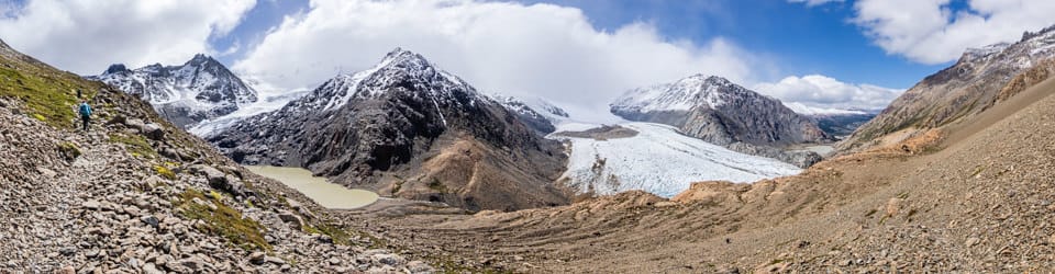
Walking the Sgùrr Alasdair route on Friday, August 5th, 2005, with my brother Peter was a classic Skye experience—demanding, dramatic, and unexpectedly rewarding. The day began under a blanket of mild, clouded weather: steady, still, and almost serene. We started from Glen Brittle, tracing the well-trodden path that leads gently uphill toward Coire Lagan, where the moody cloud lent the corrie a mystical feeling and kept the mountain’s summit shrouded.
Max elevation: 883 m
Total climbing: 881 m
Total descent: -879 m
Average speed: 2.07 km/h
Total time: 04:58:56
Beyond Coire Lagan, the real challenge presented itself: the Great Stone Chute. Ascending the chute, with its loose scree, was a slow battle against sliding stones, each step upward making us grateful for dry conditions and the absence of rain—the going was strenuous, but at least our feet weren’t soaked. The surroundings alternated between veiled mist and flashes of clarity, adding a heightened drama to every upward glance.

Peter
Near the col at the top of the chute, the clouds began to part, revealing brilliant blue sky overhead and opening out magnificent views across the Cuillin, the Inner Hebrides, and the Atlantic. Between the occasional passing wisps of mist that drifted across, surrounding us and briefly obscuring ridges and neighbouring peaks, the sense of exposure and accomplishment intensified. Scrambling the last section to the summit—a narrow crest—was exhilarating, especially as sunlight broke through, illuminating the depths below and far horizons beyond.
The summit of Sgùrr Alasdair that day was a world apart: compact, windswept, yet offering a panorama that few places in Britain can match. The air was mild, the views breathtaking, and the moment felt even more special for sharing it with Peter—alone above the island with the shifting clouds and endless sky for company.
Descending was just as much an exercise in concentration, carefully negotiating the loose scree of the Stone Chute and retracing steps through Coire Lagan, occasionally pausing to watch cloud shadows move across the slopes below. Returning to Glen Brittle, there was a deep sense of satisfaction—a day shaped by challenge, camaraderie, and unforgettable Highland scenery.
The local landscape features, geology, scenic highlights, flora, fauna and history. (Perplexity AI Model)
Landscape Features
The area encompassing Loch Brittle, Glen Brittle, Allt a’ Mhullinn, Loch an Fhir-bhallaich, Coire Lagan, the Great Stone Chute, and Sgùrr Alasdair (993 metres) on the Isle of Skye is noted for its rugged and dramatic landscape. Loch Brittle is a wide sea loch, opening to the south-west, with a grey sandy beach, exposed rocky outcrops, and steep headlands. Glen Brittle is a broad glacial valley bordered to the east by the Black Cuillin range, with many streams descending via waterfalls into the glen. The Allt a’ Mhullinn stream and Loch an Fhir-bhallaich lead uphill through moorland and woodland pockets, ultimately entering the glacially-formed Coire Lagan, an enclosed amphitheatre ringed by high cliffs and scree slopes. The Great Stone Chute, a steep and unstable scree gully, offers the standard pedestrian route from Coire Lagan to the summit of Sgùrr Alasdair.
Geology
The geology of the Black Cuillin is dominated by gabbro, a coarse-grained igneous rock notable for its durability and high friction, favoured by climbers for its grippy surface. Sgùrr Alasdair, like the rest of the range, is primarily gabbro with bands of basalt and other volcanic products. This volcanic bedrock results from tertiary igneous intrusions, and over time, glacial activity and severe weathering have carved out steep corries and sharp ridges, creating the jagged profile that defines the region.
Scenic Highlights
Key scenic highlights include the panoramic views from Glen Brittle beach towards the Hebrides; the blue-green lochan of Coire Lagan nestled below the cliffs; and the breathtaking vistas from the summit of Sgùrr Alasdair, the highest point on Skye. On clear days, these vantage points offer panoramic views over the Atlantic and the Inner Hebrides, while passing mist adds a sense of transience and drama to the mountain scenery.
Flora
The local flora varies with altitude and substrate. Lower elevations around Glen Brittle and Loch Brittle support coastal grasslands interspersed with heather, bracken, and some native woodland—chiefly birch and rowan. On the higher, thinner soils and scree of the Cuillin slopes, vegetation is dominated by tough grasses, mosses, lichens, and alpine species able to withstand exposure, such as saxifrage and mountain sorrel.
Fauna
Faunal diversity is notable, particularly among birds and mammals. Glen Brittle supports populations of red deer, rabbits, otters, and foxes. The coastal areas attract seals, porpoises, and on rare occasions, basking sharks. Avifauna includes golden eagles, ravens, oystercatchers, curlews, ringed plovers, swallows and grey heron. The upper slopes and cliffs also provide habitat for specialised insect and plant life adapted to the harsh conditions.
Indigenous History
The traditional custodians of the Isle of Skye are the Picts, who inhabited the region during the Iron Age circa 500 BCE. Their presence is evidenced by archaeological sites, including brochs and defensive structures throughout the island. Skye forms part of the wider lands of the Gaelic-speaking Scottish Highlands, with cultural heritage rooted in both Pictish and later Scottish Gaelic traditions.
White History
Norse settlement began in the 8th and 9th centuries CE, leaving a legacy of place names and cultural influence. From the medieval period, Skye was dominated by Highland clans, primarily Clan MacLeod and Clan MacDonald. The 18th and 19th centuries saw far-reaching social change, including the Jacobite uprisings and the Highland Clearances; Glen Brittle and its surrounds witnessed both clan conflict and the forced removal of residents, particularly during agricultural consolidation and emigration waves. In the 19th century, the MacAskill clan managed portions of Glen Brittle, and the area was ultimately depopulated due to amalgamation of small farms and clearances.
Today, this combination of geologic grandeur and layered human history forms the rich backdrop to the hiking experience on Sgùrr Alasdair and its approach via Glen Brittle and Coire Lagan.
Clickable icons on a world map that open the related trip report
A detailed, searchable trip list with links to reports, photo galleries and other content
![]()