
Tuesday 10/10/2023 Bainggug (The Piccaninny) Carpark – The Piccaninny Walk – The Piccaninny (448m) – Mount Sturgeon Track – Wurgarri (Mount Sturgeon) (580m) – Grampians Peaks Trail – Wannon River – Dunkeld
Grampians National Park, VICTORIA
Gariwerd Country
Participants: Stephen Davies (Photos, Report), Sue Davies, Trish Law, Dave Whitelaw
As we drove heading north from Dunkeld there was a shroud of low cloud concealing the summit of Mount Abrupt. After parking at Bainggug (The Piccaninny) Carpark we headed off along The Piccaninny Walk towards The Piccaninny. The morning was cool enough to require a warm layer until near midday. We found all the tracks to be in excellent condition, it is apparent that there had been a lot of recent work done on them. Signage appeared new and there were several numbered emergency poles to let emergency services know exactly where you were. Traversing sections have stone walls on their lower side building them up to the horizontal, most having had sandy gravel added as the walking surface. There are cut sandstone block steps on several steeper sections and steel steps and a bridge to the southern side of Mount Sturgeon, all combining to make it easy underfoot.
Max elevation: 605 m
Total climbing: 709 m
Total descent: -735 m
Average speed: 3.42 km/h
Total time: 06:15:27
Today there were many wildflowers out and we spotted several small orchids among them. Grass Trees (Xanthorrhoea australis) were plentiful in parts, some in flower. Native Cyprus were seen early on and whilst climbing The Piccaninny (448m) there were comments that one section looked like a planned rock garden. Behind one tree Dave almost walked into a swamp wallaby nibbling on the grass right beside the track, it seemed totally at ease with our presence and continued breakfast as we stood alongside observing and filming. Unfortunately for Trish, she missed this as she had returned to the car a little earlier, still recovering from recent surgery, regardless we were impressed with what she had done.
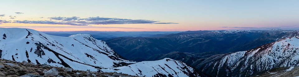
Approaching the summit of The Piccaninny we got good views back to Mount Abrupt and once beyond, Mount Sturgeon begins to appear to the south. A descent through light forest to a road (C217) ensues, another spot where parking is available for track access. Here Trish was just pulling in and would rejoin us for another short section, to the point where the track steepened at the summit climb. Just past the road, we noted a small water tank but nothing else. From here you begin the longer climb towards Mount Sturgeon, again through an abundance of wildflowers and botanic variety.

Mount Abrupt and The Picaninny from Mount Sturgeon
Further along the summit ridge to Mount Sturgeon (580m), there are excellent viewpoints to Mount Abrupt and across the extensive plains to the east and south. Along the edge of the ridge, there is an east-facing sandstone cliff line. We noted earlier many overhangs and shallow caves on the cliff face and wondered what wildlife may have made their homes in some of them. Here are lots of jagged edges, covered in multicoloured lichens and one very prominent, Instagram-worthy, overhanging tongue of sandstone trackside before the summit.
Once atop the summit we were joined by lots of butterflies darting around, some pairs putting on some “dance” moves for each other. Here we had views over the plains to the east and south, with clear views of several wind farms in the distance and today a good view of Bogong High Plains far to the east. Just to the southeast our destination of Dunkeld also appeared, about 2km away.
From the summit, the track heads towards the north-west, directly away from Dunkeld, to round the northern side of another small summit. From here there are fantastic views of the plains towards the north and west, with more of the Grampians beyond. Now starting to turn to the south the track begins its descent as it continues to wrap itself around the end of this short ridge. As it progresses and gets onto the south-facing slopes, there are good close views of the cliff line above and here you encounter some steel steps and short steel bridges across small gullies.
During the descent, there is a dense patch of Grass Trees before the vegetation changes again several times with dense ferns replacing the grass trees and the trees becoming taller below. Walking along the plains the gravelly sand track sits slightly higher than the surrounds, evidence of a lot of work that has been done here. There are three crossings of a small creek, each on arching steel footbridges. Three metres off the track along this section I noted a pair of shingleback lizards. Both Dave and Sue had walked straight past them, oblivious to their presence as the lizards were well-blended into their surroundings.
The final stretch into Dunkeld adjoins farmland, today as we passed a couple of workers disturbed a mob of kangaroos, so we got to watch as all thirty or so of them hopped off at speed.
Arriving back in Dunkeld we were still in good time to catch a coffee and cookie, before returning to the campground via the Visitor Information Centre where we learnt of a good shortcut for tomorrow’s planned walk to Signal Peak and Mount Abrupt.
Information on Victorian National Parks signage along the way
There is something to discover at any time of year on this easy walk
Welcome…. Piccaninny
Walk through low open stringybark forest to an array of spring wildflowers varying in colour, size and shape. Testimony to the park’s diversity and richness 30 of the Grampians Regions 1,000 native plant species are found only in the National Park. Climb to the top and be rewarded with panoramic views of mountains, farmland, Volcanic Plains and the township of Dunkeld. Tune your eyes and ears into what surrounds you Not everything is always easily seen Look for animal tracks, scratching on tree trunks and foot prints on the ground. Look skyward for eagles and falcons and listen for birdsongs and animals rustling in the bushes.
A flower for every season
See if you can identify the following plants.
Autumn – Common Correa, large pendant, red, yellow-tipped bell-like flowers
Winter – Common Heath, small pink or white bells of Victoria s floral emblem.
Spring – Waxlip-orchid, dainty and purple with five petals.
Summer – Austral Grass-trees, graceful fountain of long, pointed wire-like leaves, they send up tall flower spike or kangaroo tail’ after wildfire
Did you know?
The skirt of grass-trees is an important habitat for bandicoots and other small native mammals. The gum from the trunk was used to glue Aboriginal tools.
Step onto a new adventure
The spectacular 160km Grampians Peaks Trail is a once-in-a-lifetime hiking experience that can be done as the full 13 day/12 night hike, traversing north to south, or in shorter sections with many different trail options for hikers to enjoy
Dunkeld Trailhead
Mt Sturgeon (Wurgarri)
Grade 4: (Hard) all 3 options One-way 9.3km 3.5 hours.
Walks options 1 & 2: feature a gentle approach via ancient redgum wooded slopes with kangaroo and emus, before the steep ascent to this most southern summit.
Walk option 3: Features stunted vegetation, spring wildflowers and steep rocky terrain with panoramic views of the plains.
1. Start from Dunkeld: via the summit and on to Victoria Valley Road Trailhead:
Car shuffle / pick up needed.
2. Start from Dunkeld: (to the summit) Return: 13.6km, 5 hours.
3. Start from Victoria Valley Road Trailhead
4. Return: Summit: 5km 2 – 2.5 hours Loop: 7.7km, 3 hours From the summit, return via a loop connecting with Mt Sturgeon Carpark and on back to Victoria Valley Road Trailhead.
Bainggug (The Piccaninny)
An easier alternative to the harder Mt Abrupt (MudDadjug) and Mt Sturgeon (Wurgarri) hikes, but with similar panoramic views and spring wildflowers.
Grade 3: (Medium) for both walks
Drive to these two walk options
1. Start from Victoria Valley Trailhead:
2.8km, 1 – 1.5 hours return, or
2. Start from The Piccaninny Carpark:
(Bainggug) off Grampians Tourist Road 2.4km, 1 hour return.
Signal Peak
A steady uphill hike, rising through heathy low forest, passing below rocky escarpments and then up into a saddle with tall trees before approaching Signal Peak (elevation 780m).
Return walk: 7,8km, 3 – 4 hours Grade 4: (Hard)
Caring for Country
Grampians National Park is a rich cultural and ecological landscape embedded in the Greater Gariwerd cultural landscape. It is unique and is listed on Australia’s national heritage register for its Aboriginal cultural heritage, dramatic landscapes, diversity of flora and fauna and protection of threatened species.
Leave no trace of your visit – care for Country.
Gariwerd rises clear of the sea
“Nature is ever at work building and pulling down, creating and destroying, keeping everything whirling and flowing, allowing no rest but in rhythmical motion, chasing everything in endless song out of one beautiful form into another.” – John Muir
Dreaming story of Tchingal
Gariwerd’s rocky outcrops, gullies, and streams are more than features of the land – they are links to the Dreaming and the ancestors, to be respected and treated with love.
In the beginning, the ancestor beings journeyed here, shaping the landscape.
Tchingal was a gigantic and ferocious emu. He was the protector of one precious egg.
One day, while Tchingal was away from the nest, Waa the crow flew by. The crow was hungry, so he picked at the egg. When Tchingal saw this, he was furious. He chased Waa the crow all the way to Gariwerd.
Waa flew into a crack in the mountains, but Tchingal ran and struck it with his foot. The rock split in two, creating Barigar (Roses Gap), meaning ‘mountain stream’. The crow flew on, but the emu was close behind. Again, Waa hid in the mountains, but Tchingal kicked them right open. This created Jananginj Njaui (Victoria Gap), allowing Bugara (Glenelg River) to flow out on to the western plains.
A blank sheet of sea and sky
In simplified terms, an ancient mountain range towered above a deep surrounding sea.
Over a vast sweep of time, the ancient highland peaks were worn down by eons of erosion. They were stripped down, disappearing to become the floor of a shallow ocean.
The sediments cemented together and after hundreds of millions of more years were thrust skyward to create a new place – Gariwerd.
It took a violent tectonic event to wake Gariwerd from its slumber. Western science suggests that 500 million years ago, the landscape you see here was covered by a deep ocean.
So, the mountain range you hike today, began in a basin at the bottom of a shallow sea (verified by fossil records), filled with mud, minerals and rock forms eroded from the older exposed highlands.
Saved by a hard cap
In geological terms the distinctive topography of this region is a result of folding and faulting, and subsequent erosion of quartz capped, sandstone ranges.
If it were not for that cap of resilient quartz, these mountains may also have become rubble eons ago. As it is, the softer red siltstones and sandstones have eroded to form the valleys between the ranges.
Gariwerd is a member of our family – like our grandmother, our mother, our sister, our daughter… Our reunion with Gariwerd reaffirms our obligations to look after our family member, our Country.
The garden of Victoria
When botanist Ferdinand von Mueller set out to explore the western and northern regions of Victoria in late 1854, he was so impressed by the Grampians variety and diversity of flora that he referred to the ranges as “the garden of Victoria.”
Carpets of colour
Gariwerd is home to one-third of all Victorian plant species. Mountains, wooded slopes, heathy valleys and sandy swamp floors providing myriad niches for a wide variety of plants to thrive.
Colour your world
In any month of the year there is a plant waiting for you to discover its silent beauty through petal, leaf or bark. Look to nature’s colour palette for the: reds of flame grevillea, running postman; golds of guinea flower and wattle; blues of tinsel lily, daisies and love creeper, mauves, pinks, purples of orchids, heath and pink bells; delicate pinks and whites of snow myrtles and the snow whites of the unique Grampians Thryptomene.
Wonders of nature From as early as the 1860s the scenic beauty of the area, particular around Halls Gap, was a great attraction for artists, naturalists and newspaper correspondents
The Grampians also became a magnet to other adventurers wanting to experience the wonders of nature’
‘In the early 1890s, the Chautauquan Movement was formed in the USA in 1874, The movement’s teaching was a mixture of intellectual and spiritual studies along with the promotion of a healthy living and appreciation of the natural world. Several large gatherings occurred in Halls Gap around 1893-4 and local residents of Halls Gap were inspired to name the rocky outcrop overlooking the picnic site as Chautauqua Peak.’
Extract from Victoria’s Wonderland, A Grampians history: Halls Gap & Grampians Historical Society Inc.
Alive with variety
Close to 1,000 different flowering plants occur in the Grampians National Park, almost one-third of Victoria’s entire indigenous flora.
The tricky little sundew, with its sticky little hairs, catching unsuspecting insects with its tiny, sticky snares!
During winter, spring and early summer look for sundews low on the ground. About as wide as a 50 cent coin, the tiny, scented sundew packs a bite in order to gain extra food not found in the soil! Don’t be fooled by its beauty – this hungry plant lures insects onto its sticky red or green leaves, trapping them for dinner.
The world’s first bread was baked here, using flour ground from murnong (yam daisy). The plant’s edible tubers grow underground, like potatoes. Gariwerd was once rich in murnong, grown and harvested by Traditional Owners, who used its starch rich tuber as an important food source.
Fire triggers new life
You might recognise the bristly, flowering cones of the rock banksia. While in bloom, birds such as honeyeaters will sip nectar from the flowers. Fire kills the adult banksia plants, although the hard woody cone has adapted to live with fire. It protects the seed, opening after fire, allowing the seedlings to rise from the ashes
Fire triggers new life
You might recognise the bristly, flowering cones. of the rock banksia. While in bloom, birds such as honeyeaters will sip nectar from the flowers. Fire kills the adult banksia plants, although the hard woody cone has adapted to live with fire. It protects the seed, opening after fire, allowing the seedlings to rise from the ashes.
Ancient and unique to Australia, Grass-trees have adapted to flourish following wildfire when they send tall flower-spikes skyward; attracting eager flower pollinators and providing vital food for recovering wildlife.
A mountain wildlife refuge
Many special animals call central Gariwerd home; birds, mammals, insects and crustaceans – some so rare this is their last foothold on earth, their final refuge for survival in a rapidly changing world
Peregrine Falcon
What did I see that morning?
That crossbow silhouette, that sabring fall from the sky… quick striking curve… unmistakably a peregrine.
Hot winter sun on the face’s brink, felt as red but seen as gold Air, still, blue.
Tremors at the edge of vision: quick dark curve and slow straight line over green, gold in the aye Intersection, shrapnel of down, grey drop to crop, flail and clatter, four chops and the black star away with quick wing flicks.
– J A Baker (The Peregrine)
Mountain Galaxia As you pass flowing streams and sandy pools, watch for a glimmer of the tiny native Mountain Galaxia fish. Smaller than your palm, they are often seen feeding on insects amongst rocks or waterside plants.
Other fantastic beasts found include glowing scorpions, land snails hungry for flesh, and pinching swamp crayfish.
Rocky daredevils bounce back
Among the wild jumble of rocky knolls and cliffs springs a shy, marsupial acrobat.
Their padded, flexible feet and brushy tipped tail help them bounce and balance as they ricochet across rocky ledges and uneven ground.
Once hunted for their meat and fur, Brushtailed Rock-wallabies are now critically endangered in Victoria due to overhunting and predation from foxes.
A successful breeding 20 relocation program has returned these rocky daredevils back among the lofty crags and crevices of Gariwerd.
From Grampians National Park Visitor Guide
Environment, culture and heritage
Aboriginal cultural heritage
The park, traditionally known as Gariwerd, has an Aboriginal cultural history dating back at least 22,000 years. The landscape holds this heritage and protects many important cultural sites, including the largest collection of rock art in south-eastern Australia.
Begin your cultural journey at Brambuk, or visit one of five easy to access rock art shelters open to the public; Ngamadjidj, Gulgurn Manja, Billimina, Manja and Bunjils (Black Range Scenic Reserve near Stawell).
Post settlement history
The Grampians was named after the Grampian Mountains in Scotland by Major Thomas Mitchell on his 1836 expedition. Since this time the area has seen much change through resource industries such as forestry, stone quarrying, gold mining and water harvesting. People have been drawn here for thousands of years and tourism established its roots in the early 1900s. More than 1.3 million people from all over the world visit the park annually.
Geology
The four distinct sandstone ranges of the Grampians began forming approximately 430 million years ago. Over time, geological processes such as pressure, heat, folding, faulting and erosion have slowly shaped the mountains we see today. Geology is fundamental to soil composition and influences where flora found here.
Plants
The park protects one third of Victoria’s flora species and is the most important botanical reserve in the state. Close to 970 native species occur and over 40 are found nowhere else in the world. The area is known for its colourful spring wildflower displays and popular walks include Heatherlie area, Sundial Peak, The Piccaninny and Mt Zero.
Wildlife
The park provides habitat for at least 230 bird, 40 mammal, 30 reptile, 11 amphibian and 6 native fish species. There are 50 known species in the park classified as threatened, including Brush-tailed Rock Wallabies, Smokey Mice and Powerful Owls. Halls Gap and Fyans Valley are one area to see Eastern-grey Kangaroos, Emus and to hear kookaburras. Usually at dawn and dusk.
The local flora, fauna, geology and history (Bard)
Flora
Grampians National Park, also known by its Aboriginal name Gariwerd, is a national park located in the Grampians mountain range in western Victoria, Australia. The park is home to a diverse range of flora, including over 900 species of vascular plants.
The park’s forests are dominated by eucalypts, such as the river red gum (Eucalyptus camaldulensis), swamp gum (Eucalyptus ovata), and manna gum (Eucalyptus viminalis). Other common trees include the black wattle (Acacia mearnsii), silver banksia (Banksia marginata), and mountain ash (Eucalyptus regnans).
The park’s understorey is home to a variety of shrubs, herbs, and grasses. Some of the most common shrubs include the wattleseed (Acacia acuminata), hop bush (Dodonaea viscosa), and prickly bush-pea (Pultenaea scabra). Common herbs include the kangaroo apple (Solanum aviculare), billy buttons (Craspedia chrysantha), and blue leschenaultia (Leschenaultia biloba).
The park’s flora is adapted to the region’s Mediterranean climate, with hot, dry summers and mild, wet winters. Many of the plants are drought-tolerant and have deep roots to reach water stored in the soil. Others are fire-tolerant and have mechanisms to regenerate quickly after fires.
Fauna
Grampians National Park is home to a variety of fauna, including over 200 species of birds, 60 species of mammals, and 40 species of reptiles.
Some of the most common birds in the park include the laughing kookaburra (Dacelo novaeguineae), kookaburra, eastern grey kangaroo (Macropus giganteus), and common wombat (Vombatus ursinus). Other notable species include the emu (Dromaius novaehollandiae), wedge-tailed eagle (Aquila audax), and peregrine falcon (Falco peregrinus).
Some of the most common mammals in the park include the echidna (Tachyglossus aculeatus), platypus (Ornithorhynchus anatinus), common brushtail possum (Trichosurus vulpecula), and sugar glider (Petaurus breviceps). Other notable species include the koala (Phascolarctos cinereus), rock-wallaby (Petrogale assimilis), and dingo (Canis dingo).
Some of the most common reptiles in the park include the eastern brown snake (Pseudonaja textilis), tiger snake (Notechis scutatus), and red-bellied black snake (Pseudechis porphyriacus). Other notable species include the bearded dragon (Pogona barbata), goanna (Varanus giganteus), and tortoise (Chelodina longicollis).
Geology
Grampians National Park is located in the Grampians mountain range, which is made up of sandstone and quartzite rock. The rock was formed over 400 million years ago, when the region was part of a vast ocean. Over time, the ocean receded and the land was uplifted, forming the mountains.
The sandstone and quartzite rocks of the Grampians are resistant to erosion, which is why the mountains have remained relatively unchanged for millions of years. However, the rocks have been weathered and eroded over time, forming the park’s distinctive rock formations, such as The Pinnacle and The Balconies.
Indigenous History
The Grampians National Park is the traditional home of the Djab Wurrung and Jardwadjali people. These Aboriginal groups have lived in the region for over 22,000 years.
The Djab Wurrung and Jardwadjali people have a deep spiritual connection to the land of Gariwerd. The park’s many rock art sites are testament to the long and rich history of Aboriginal culture in the region.
The Djab Wurrung and Jardwadjali people were forcibly removed from Gariwerd in the 19th century. However, they have maintained their connection to the land and continue to fight for its protection.
White History
The first Europeans to visit the Grampians were explorers Hamilton Hume and William Hovell in 1824. The first settlement in the region was established in 1836.
In the early years of European settlement, the Grampians were used for grazing sheep and cattle. However, the region’s sandstone and quartzite soils are not well-suited for agriculture. As a result, the Grampians became a popular destination for recreation and tourism.
In 1984, the Grampians National Park was established to protect the region’s natural environment.
Clickable icons on this world map will open the related trip report
A detailed, searchable trip list with links to reports, photo galleries and other content
![]()