
Friday 10/03/2023 Darby Beach Carpark – Tongue Point Track – Fairy Cove – Lookout Rocks – Tongue Point
Wilsons Promontory National Park, VICTORIA
GunaiKurnai and Boonwurrung Country
Participants: Stephen Davies (Photos, Report), Sue Davies
We departed Darby Beach Carpark at 9:40am, appreciative of it being heavily overcast but for the first time in many days not windy or raining. We had been to Darby Beach on the Wednesday but the weather to too unpleasant for us to be tempted to start out.
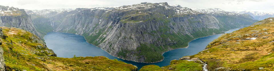
The Tongue Point Track gradually climbs from the carpark to provide a good view of the meanders of “Darby” Creek to the east as it passes through thick heath. After climbing about 90m you pass through a saddle to catch your first glimpse of Tongue Point, immediately you realise this is going to be a very scenic walk.
Max elevation: 263 m
Total climbing: 912 m
Total descent: -911 m
Average speed: 4.31 km/h
Total time: 03:56:28
As you walk to the south the track follows the contours. The track itself is narrower, rougher and more eroded than many others in the park. There are extensive views up to Waratah Bay in the north, Norman Island, the Citadel Island Group and Tongue Point in the south.
Our first side trip was down to Fairy Cove, a small sandy beach sandwiched between rounded granite boulders. This is a beautiful little spot and is not to be missed.
Next up we had a steady uphill climb as we aimed for Sparkes Lookout. This wind-blown area had much shorter heath than elsewhere but as you get higher it regains more height. The views continue to improve as you climb towards the lookout and really open up the views to the south when you arrive. We were a little puzzled by the sign itself saying Lookout Rocks but nonetheless appreciated the impressive views.
From here we turned back and headed down to the rocks at the end of Tongue Point Track. Here we had a couple of birds join us for a while. A juvenile Pacific Gull was especially seemingly interested in our presence whilst also grabbing a snack in the form of the red berries on some of the heath.

Juvenile Pacific seagull at Tongue Point
The return to the carpark saw a lot more people on the track which was hardly surprising as we were coming into a Victorian long weekend holiday. The Parks Cafe makes a good veggie burger, so we headed back there for lunch and a sneaky shower before we left Wilsons Prom altogether. Sometime during the early afternoon, we realised there were two lookouts close together, Sparkes Lookout being about 1km further on past Lookout Rocks where we stopped. We had also been planning to walk to the top of Mount Oberon today but as it had been under cloud we decided to look elsewhere first. We also found that the road to Telegraph Saddle is only accessible via the shuttle bus service (the road is closed in busy periods as the carpark is very small). Now, we may need to visit again!
The local flora, fauna, geology, history and some other walks (ChatGPT)
Welcome to Wilsons Promontory National Park, a stunning natural wonder located on the southernmost tip of mainland Australia.
The park was once covered in dense forests, with towering eucalyptus trees and a diverse array of undergrowth. The park was home to many unique species of flora, such as the bright yellow Wattles, which bloomed in the winter months, and the delicate native orchids that could be found throughout the park.
The fauna of the park was equally fascinating, with many species of marsupials, including kangaroos, wallabies, and possums, who thrived in the dense forests. The park was also home to several species of reptiles, such as the venomous tiger snake and the harmless blue-tongued lizard.
The geology of the park was also unique, with a mixture of granite, sandstone, and limestone formations. The park’s coastline was particularly stunning, with towering cliffs and pristine beaches that were home to many marine species, such as the Australian Fur Seal.
The park also has a rich cultural history, with evidence of Aboriginal occupation dating back over 6,500 years. The Boonwurrung and Wurundjeri people were the traditional owners of the land, and they used the park for hunting, gathering, and spiritual ceremonies. The park’s name “Wamoon” means “east wind” in the Boonwurrung language.
One of the most popular walks in the park was the Sealers Cove Track, which took you through dense forest and down to the stunning Sealers Cove. Along the way, you could spot many unique species of flora, such as the pink-flowering heath, which bloomed in late winter and early spring. The track also took you past several waterfalls, such as the Fairy Cove Falls, which cascaded down the cliffs into the sea.
Another popular walk was the Mount Oberon Summit Walk, which offered stunning views over the park and the coastline. The track took you up through the dense forest and past rocky outcrops until you reached the summit, where you could enjoy panoramic views over the park and the ocean.
Sadly, the park has undergone significant changes over the years, with large areas of forest being cleared for agriculture and development. The park has also suffered from wildfires and invasive species.
Clickable icons on this world map will open the related trip report
A detailed, searchable trip list with links to reports, photo galleries and other content
![]()