
1/03/2017 – 11/03/2017 The O Circuit
Torres del Paine National Park, CHILE
Distance: 196km Total Ascent: 9100m Total Descent: 9100m Time: 73 hours
Participants: Stephen Davies (Photos), Sue Davies (Report)
The Torres del Paine circuit, otherwise known as “The O Circuit”, is considered one of the world’s truly great treks. The route includes the shorter “W” Circuit, side trips to the iconic towers or “Torres”, the beautiful Valle Frances, crossing over the Paso John Gardner and the expansive Grey Glacier. The walk is situated in Chile’s Torres del Paine National Park, at the southern tip of the South American continent, in the area known as Patagonia. The park sits on the edge of the Southern Patagonian ice field, the largest sheet of ice in the southern hemisphere outside of Antarctica.
The start of the walk can be reached from the southern town of Puerto Natales with regular buses travelling to the park during the walking season from late November to late April. Direct flights to Puerto Natales are available twice weekly from Santiago with Sky Airlines.
Day 1: Wednesday 1/03/2017 Pudeto – Lodge de Montana Paine Grande
Max elevation: 286 m
Total climbing: 418 m
Total descent: -484 m
Average speed: 3.86 km/h
Total time: 02:05:17
We had an early start from Puerto Natales with the bus picking us up at 7:00am. This first ride only took us to the nearby bus terminal, where we disembarked, walked through the terminal, handed in our bus ticket and got back on the same bus, which had moved around to the other side of the terminal.
The bus trip took about two hours to arrive at the CONAF (national parks) Administration Centre, where we again disembarked, filled in a form, paid our park entry fee and watched a video outlining the park rules. The procedures within the park have tightened significantly following several fires after campers were careless with fires or camp stoves, causing immense environmental damage. Apparently, the park sees between one thousand and fifteen hundred people per day at this time of year. It was very impressive to see so little rubbish around, considering those numbers.
Next, we were again on the bus for the drive to Pudeto, located on the north-eastern shore of Lago Pehoe. We waited in breezy conditions near the wharf. The catamaran was full of hikers when it departed, and we were a little surprised at how many people seemed to be around in this later part of the walking season. The pile of backpacks on board was impressive. It was a thirty-minute ride across the lake to Lodge Paine Grande, which is positioned on the western edge of Lake Pehoe.

Campamento at Lodge Paine Grande
We then walked through a little rain to check in at the campground. We found a reasonable campsite, prepared for the legendary winds of Patagonia. After setting up the tent, a family of Andean foxes entertained us in the middle of the campground.

Andean foxes at Lodge de Montana Paine Grande campground
As the weather was now reasonable (not raining), we decided to walk along the track towards Campamento Italiano for some views. On this short excursion, we gained good views of Cerro del Paine, Cordillera Paine and Cuernos del Paine before returning to the Lodge for some pre-dinner relaxation.
Dinner was cafeteria style – yes, everyone had to line up with their tray to be served! We had obviously been spoiled by the European Refugios.
Day 2: Thursday 2/03/2017 Refugio Paine Grande – Campamento Italiano – Campamento Italiano – Valle del Frances
Max elevation: 758 m
Total climbing: 1243 m
Total descent: -1121 m
Average speed: 4.00 km/h
Total time: 09:22:07
We awoke to a beautiful morning after a sound sleep. After collecting our packed lunch, we headed off after breakfast, pleased to be able to pack a dry tent. The fox family were again out playing nearby as we left. There were several big groups heading out at the same time, mainly day trippers.
It was fairly easy going as we walked around Lago Skottsberg and it was not too long before we reached Campamento Italiano. Here we found a reasonable spot but most of our selected site, although well sheltered, was muddy and iIt was just as full as was Paine Grande. The board at the rangers hut had a sign stating: “Don’t ask about the weather, this is Patagonia! We don’t know!”
We set up our tent and ate half of our packed lunch (it was huge!). We had a great chat with a lovely Chilean couple but couldn’t linger as we had a long walk planned for the afternoon.
We headed off for Valle Frances around 1:30pm. It was a bit drizzly and misty but the scenery was incredible. We listened to glaciers cracking and watched avalanches pouring across and off rock faces.

Cuenos del Paine from Rio del Frances
We followed the valley to the end point of the trail although it was fairly foggy. We knew we weren’t seeing it as it’s best. We were lucky that on our return the sky cleared and produced incredible views, including a panoramic vista of towering peaks and glaciers. The forest we walked though into the valley was also very beautiful. Needless to say, there were many photo stops which meant we didn’t get back to camp until 6:40pm.
Day 3: Friday 3/03/2017 Campamento Italiano – Refugio Las Torres
Max elevation: 402 m
Total climbing: 1078 m
Total descent: -1148 m
Average speed: 3.78 km/h
Total time: 08:22:46
Wet, wet, wet! It seemed to rain most of the night and it was still raining when we awoke. Welcome to Patagonia! Sue’s side of the tent was in a pool of water and nearly everything was wet and muddy. Negotiating the mud and water meant It took ages to pack up in the rain. Sue prepared breakfast whilst Steve dealt with the tent and we eventually set off at 9:40am.
At breakfast as we stood in the rain in full wet weather gear. Sue in speaking with an American walker came to the conclusion that walking trips were a bit like life in general, that is, not all about sunny days. The rainy days make you appreciate the fine ones and in life you are not always on top of the world but it does help you to appreciate the good days.
The trail now followed the shores of Lago Nordenskjold for much of the day. Partway along the lake the track descended to a delightful multicoloured pebbly beach which contrasted beautifully with the aqua coloured water.

Sue on track along Lago Nordenskjold
We continued in the rain to Refugio Los Cuernos where we stopped for a hot drink. Steve couldn’t resist one of the massive $10 donuts on offer. After this indulgence, we set off thinking we had only about four hours to go – wishful thinking.
The path along the lake was undulating, making for somewhat tiring walking. As the weather gradually cleared we were rewarded with great views of the surrounding glaciers and mountains including Cuerno Este which was now just behind us.
Near Laguna Inge we missed the turn for Refugio Torres and inadvertently commenced ascending and heading away from our destination on a side track. A large group of people that caught our eye, who were near the lake were most likely standing in front of the sign as we walked past. Much later, one of those people told us he had tried to call out to us but we didn’t hear him. Before we confirmed our error we were so far along the deviation we decided to continue and then head down a main track that led back to our destination. We were unaware at that stage how far we would need to ascend. We had really over shot our destination. Eventually, we found the track back down and we were feeling very fatigued after many hours of walking. We arrived at Refugio Torres North at 5:40pm, eight hours after starting. We had had very few stops and no lunch during the day.
We were so pleased to have a shower and a cooked meal. It had been a big day. We were seated for dinner next to a lovely couple from Brazil giving Sue an opportunity to practice her limited Spanish. However, we faded rather quickly and headed off to bed rather early.
We are yet to experience the famed Patagonian winds.
Day 4: Saturday 4/03/2017 Refugio Las Torres – Campamento Torres
Max elevation: 875 m
Total climbing: 1264 m
Total descent: -823 m
Average speed: 3.33 km/h
Total time: 09:32:56
We had a great sleep in fresh sheets in a real bed! We just made the 7:00am breakfast. It was a good thing we did as from the dining room there were great views of the towers and we got to see them turn pink at sunrise! What a sight!
We headed off on a beautiful morning, sunny with no wind. We climbed back up the trail we had to come down yesterday, this was a little disheartening but the weather and views made it worthwhile.
After reaching a high point the track descended to Refugio El Chileno and then through a beautiful forest past waterfalls along Rio Ascencio. As planned we arrived at Campamento Torres around lunchtime to set up camp.
After lunch and a hot drink we were heading up to look at the towers.

Torres del Paine
The view was incredible. We were lucky enough to see it under clear skies. We saw condors soaring above the crags and there seemed to be a resident fox looking for scraps. Lots of people had headed up for a day walk but it didn’t detract from the beauty of this place. We lingered for 2.5 hours before descending to prepare our campsite dinner and get ready for our return to the towers for a sunrise viewing.
Day 5: Sunday 5/03/2017 Campamento Torres – Refugio El Chileno
Max elevation: 880 m
Total climbing: 605 m
Total descent: -919 m
Average speed: 3.08 km/h
Total time: 10:42:21
Steve arose at 3:30am in the hope of some star trail photography with a spectacular back drop. He had actually planned to wake at 2:30am but he delayed this during the night. He was excited about the possibilities as he climbed up the trail under the moonless and cloudless sky.
Sue slept in until 5:45am aiming just to catch the sunrise on the towers. Both of us walked the one hour trail in the dark, for Steve it was pitch black and he actually lost the trail and took 1.5 hours to reach the mirador (lookout).
The predawn air was very cool at the top even in the absence of wind. Unfortunately, the clouds rolled in just before sunrise and the view of the towers was not as spectacular as what we had seen the previous afternoon. We did get a brief pink tinge on the glacier at 7:26am but this was very short lived. It is still an incredible place regardless of the conditions.

Torres del Paine
Sue decided to head back to camp for a hot breakfast about an hour later. Steve persisted for a short time before it started to rain lightly and he also retreated to camp. We enjoyed a hot drink in the tent and a short snooze before packing up wet gear again.
It only took one hour and fifteen minutes to reach Refugio El Chileno. Here we had a relaxing afternoon even though the showers were cold.
The evening was spent enjoying a delicious multi course dinner while having interesting conversations with trekkers from China, USA and Canada.
Day 6: Monday 6/03/2017 Refugio El Chileno – Campamento Seron
Max elevation: 416 m
Total climbing: 633 m
Total descent: -864 m
Average speed: 4.19 km/h
Total time: 05:58:28
Sue woke up at 5:00am with a very red and swollen right eye. It certainly looked like she needed to seek medical treatment and this then may end up being the end of our walk.
The young woman at the Refugio front desk felt certain Sue’s inflamed red eyelid was a result of an insect bite and kindly gave her two tablets (presumably an antihistamine). Immediately after we happened to be in the corridor discussing how Sue planned to see if there was a medical clinic in the Torres village when a nearby fellow trekker who overhead the discussion said that he was a doctor and offered to look at Sue’s eye. His friend was also doctor so a second opinion was readily available. They both agreed with the young woman at the front desk that it was indeed most likely the result of an insect bite and Sue was fine to continue. What a relief!!
We had good views of the top of the towers from the refugio at breakfast. They put on a show of their spectacular colours at sunrise so we were very happy for all the trekkers who had made the pre dawn hike up the mountain from the refugio.

Torres del Paine sunrise from Refugio Chileno
We headed off a little later than usual but our delay was worth it as we didn’t have to stop in the village and try to find a doctor.
We descended again to Refugio Las Torres and after passing this we were finally leaving the W Circuit and on backend of the O Circuit! We stopped for a short time talking to a young man whose job was to improve signage along the trail – did we had some feedback to give him! He said everyone gets lost somewhere on the trail, even he had going up to the towers in the dark.
Now on the “O”, straight away, it was much less crowded. Today was a day of stream crossings but luckily we didn’t need to remove our boots. We climbed fairly gently up over a ridge and then descended with views of the meandering blue Rio Paine.
It seemed to take a while after we reached the flat before we arrived at Campamento Seron. We had walked about six hours and were certainly ready to stop for the day.
Campamento Seron was situated in a pleasant spot with grassy camp sites (all of the others so far had been on dirt) but the mozzies (mosquitos) were out, which Sue really wanted to avoid. This campsite had very limited facilities for a commercial campground but proved adequate for our needs with two hot showers and flushing toilets. Needless to say, there were long line ups. We were a little surprised to find flushing toilets in all the campgrounds on the circuit, including the free ones.
Before dinner we were surprised to meet Yucheng Fan from the USA who we had met at Refugio Lac Blanc last year while we were walking the Tour de Mont Blanc in Europe. She was travelling with her brother Xuqing Lu. We wondered where we would meet on our next adventure! Dinner was enjoyable in the tiny dining/kitchen area with lively discussions about walking adventures. We also met Ian from Perth who gave us some great ideas for future treks.
Day 7: Tuesday 7/03/2017 Campamento Seron – Refugio Dickson
Max elevation: 348 m
Total climbing: 725 m
Total descent: -669 m
Average speed: 4.02 km/h
Total time: 06:29:47
Our departure from camp was delayed as we needed to line up and wait for the toilets. It proved to be quite a muddy day overall and we quickly gave up trying to avoid it, so straight through the middle for us.

Sue above Lago Paine
We reached a spur above Lago Paine with lovely views of the mountains ahead and Lago Paine itself below. From here the track crossed the saddle, which according to the guide book was “remarkably blustery”. Lucky for us today there wasn’t a breath of wind.

Sue above Lago Paine
Further on there were great views of the Dickson Glacier before crossing more boggy ground until eventually we reached a shoulder where we could see the picturesque Refugio Dickson on the grassy flats below. The hot shower was most welcome!
We had a wonderful night and lots of laughs with our Chinese friend who had quickly became best buddies with a Spanish traveller who was by now his “hero” as he had been travelling for 15 months. More wine was ordered and language did not seem to matter (both had limited English but it was their common language). An excellent night, the food was good too!
Day 8: Wednesday 8/03/2017 Refugio Dickson – Campamento Los Perros
Max elevation: 567 m
Total climbing: 683 m
Total descent: -334 m
Average speed: 4.07 km/h
Total time: 04:54:25
It was very wet overnight, luckily for us we were inside. Breakfast was not available until 8:00am but was worth the wait as it included freshly baked bread! We were in no hurry to leave after breakfast as it was still raining heavily. It had eased off a bit by 10:00am so off we went.
Again the trail was very muddy but the rain quickly changed to drizzle so it wasn’t too bad. Progress was slow in the muddy conditions. The forest was bright green and mossy. There were lots of stream crossings and waterfalls alongside the now raging Rio de Los Perros.

Wet and muddy track along Rio de Los Perros
As we continued we gained great views of the Glacier Los Perros through the mist, complete with icebergs in the small lake below.
We checked into camp twice, as was also required at Refugio Dickson (firstly a form filled out at the national park office and then providing passport details at the campground). We were pleased to have a large fully enclosed communal cooking area. This was shared by the many wet campers of different nationalities.
Later that night the park staff made an announcement at the shelter telling us that due to the heavy rain the river level beyond the camp at Paso may become impassable. They told us we would be fine to get to Campamento Paso but there would be an update in the morning.
Day 9: Thursday 9/03/2017 Campamento Los Perros
Max elevation: 593 m
Total climbing: 114 m
Total descent: -114 m
Average speed: 3.58 km/h
Total time: 01:05:05
Many people headed off early in the morning hoping to make it to the Grey Glacier. There was to be an announcement around 8:00am. As it hadn’t rained overnight we thought the decision may be favourable. The Spanish speaking warden addressed the group. We went seeking the English speaking warden, not wanting to accept third hand news. He told us that the entire circuit was closed as many river levels had risen to dangerous levels overnight. We were advised to stay where we were.
There would be too many people at Campamento Paso, who had left earlier so it would be really crowded with its very limited facilities. We did have the option of walking back to Refugio Dickson but this idea was quickly discounted.
So we had no choice but to stay put and spend the day around Los Perros. The large metal clad communal area was very cold, especially wearing wet socks and boots in the hope of drying them a little. The fact that there was an “out of order” pot belly stove was very disappointing. Sue was also coming down with a cold so a rest day was in order.

Glaciar Los Perros
We went for a walk back to the Los Perros Glacier but the views were no better than the previous day. We spent the afternoon reading and chatting with fellow trekkers. Our new Swiss friend enjoyed reading a section of the Sydney Morning Herald we had brought from Australia. Very impressive considering English was probably his fourth language.
Day 10: Friday 10/03/2017 Campamento Los Perros – Refugio Grey
Max elevation: 1176 m
Total climbing: 1353 m
Total descent: -1833 m
Average speed: 3.44 km/h
Total time: 09:01:34
We awoke early and got ready to leave but still we needed to wait for the official announcement on the track status which we due at 8:00am. This would be very late to leave considering the CONAF map gives the walking time to Refugio Grey as 11 hours. There was no official announcement but about 8:10am the word was that the trail was open! We were so happy we didn’t need to walk back to Refugio Seron and beyond!
We headed off soon after and before long we were climbing up towards John Gardner Pass. It was very muddy and got colder and increasingly barren as we climbed higher.
Unfortunately, there was widespread heavy mist all around so we didn’t get the views we had hoped for. We reached John Gardner Pass after 2hours 15minutes so we were ahead of schedule. We even wondered whether it was actually the pass or had we taken a wrong turn as it seemed to take such little time. There was a cold breeze but nothing like the winds described in the guide book which we had been fortunate to avoid on this walk.
The descent was rough and muddy in places which made walking slower. As we progressed we got increasingly better views of the extensive Grey Glacier which is six kilometres wide at this point!
We descended and walked closer to the Grey Glacier and found a great view point to enjoy lunch. The sun actually came and the mist lifted to reveal some of the stunning surrounding mountains. The glacier was a massive river of convoluted ice with endless peaks and troughs.
Soon we were at Campamento Paso, a very small campsite and chatting with our friends from last night. We paused only briefly, knowing we still needed about 3.5hours to walk the last 10km.

Glaciar Grey
We walked for many kilometres along the edge of the glacier gaining views from many different angles. The trail was at times rough and we climbed up and down eroded gullies and a few metal ladders. There were a few large suspension bridges, one about 40m above the stream below. We enjoyed views of Lago Grey, the snout of the Grey Glacier and floating icebergs.
We were very pleased to arrive at Refugio Grey after a full day of walking and making it in really good time. Eight hours, not bad for two almost senior citizens. It was a bit of a culture shock to arrive at this modern hostel, complete with a bar, piped music and television!
Day 11: Saturday 11/03/2017 Refugio Grey – Refugio Paine Grande
Max elevation: 271 m
Total climbing: 820 m
Total descent: -848 m
Average speed: 3.92 km/h
Total time: 06:04:58
We had a relaxed departure, surprised we didn’t feel tired after the long day yesterday. It’s amazing what a shower and a good sleep will do.
We headed off to the mirador on Lago Grey after breakfast. It was a sunny morning and now the beauty of the mountains was fully revealed to us. We hadn’t seen any views on our walk over John Gardner Pass the previous day, now all was revealed.
We walked a short distance to the rocky promontory for views of the snout of Glacier Grey and La Isla. It was picturesque as we watched kayakers negotiating icebergs. We then headed off for the last stage of our walk to complete the O Circuit.
The trail climbed up above Lago Grey giving us good views of the lake and our last glimpses of the glacier. We passed several tarns including Laguna Los Patos and saw another condor in flight. The wind picked up during the afternoon, our first real wind in Patagonia. It seemed intent on reminding us where we were!

Cerro Espada, Cerro Hoja, Cuerno Norte, Cuerno Principal and Cuerno Este (Cuenos del Paine)
We continued on the muddy trail, it seemed we were not destined for dry boots just yet. The sight of the turquoise waters of Lago Pehoe was most welcome and Refugio Paine Grande was not much further. We had completed the O Circuit in our planned time despite flooding rains and the closure of the track. We had spoken to people last night who completed the entire W Circuit and didn’t see a thing, due to poor weather or track closure. Both the Vallee de Frances and the Torres were closed for two days in the past week as was the John Gardner Pass. We considered ourselves quite lucky to have enjoyed the the walk, the views and the comradery of this fantastic part of the world. As our new Swiss friend had told us “Its not about the destination, it’s about the journey” and we couldn’t have agreed more.

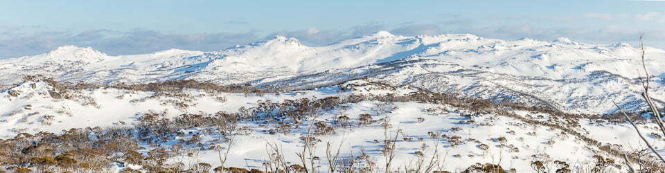
Lodge de Montana Paine Grande with Punta Banloche (Cerro Paine Grande) behind and Cerro Espada, Cerro Hoja, Cuerno Norte, Cuerno Principal and Cuerno Este (Cuenos del Paine) more distant over Lago Pehoe
A few tips for anyone considering this walk
– We used the Cicerone guide “Torres del Paine” for most of the planning for the walk. The Lonely Planet guides were useful for non-walk related information.
– As of 2017 you need to prebook well in advance to secure a place in Refugios and/or campgrounds. All need to be prebooked to allow you to commence the walk. We met lots of people who left their booking attempts too late and planned to do ridiculous distances each day. You need to book on three different websites, Fantastico Sur, Vertice Patagonia and Torres del Paine National Park for the free campsites which need to be booked online. If you don’t have a booking, you cannot camp.
– Your movement within the park is highly regulated; you need to provide your booking details and passport information in some instances, several times per day.
– It is best to plan for short stages each day in case of track closure. The next day, you may need to make up for the previous day’s distance.
– Plastic bags are not given out in the supermarkets so bring what you need with you. Two bags for wet boots would have saved me from many days of cold and wet feet.
– Be prepared for any weather conditions, including snow, cold temperatures and persistent rain.
— “A deadly blizzard struck Torres del Paine National Park in Patagonia in mid-November 2025, resulting in the deaths of five foreign hikers—two from Mexico, two from Germany, and one from the United Kingdom. The group was trekking the remote “O Circuit” near the Los Perros camp and John Garner Pass when the storm, with winds over 190 km/h (about 120 mph), brought whiteout conditions and subzero temperatures. Four other hikers from the same group were rescued alive, following a challenging multi-agency rescue operation where helicopters could not be used due to the extreme weather” Outside Magazine Report
– The information on the track status is not always consistent.
– Don’t believe the “You are here signs”. They were usually inaccurate in terms of distances and some frustrated people have carved more correct information on them.
– The W Circuit is very busy, even in shoulder season (we were told by park staff that between 1,000 and 1,500 people were still entering the park daily.
– The O Circuit provides more solitude on the track but the accomodation and campgrounds were still busy on the full circuit (there is provision for around 80 hikers at each site).
– You can start and finish the O Circuit at Torres Hotel which has road access and save on an expensive catamaran trip.
– Refugio Paine Grande is in a great setting but it is the only Refugio that serves average cafeteria style food that is very expensive. Best to bring and cook your own food here. Chileno and Torres Refugios served three courses of very good quality food, considering their location.
– Enjoy any good weather while it lasts because it won’t be for long!
– Enjoy the big smiles and cheeky sense of humour of the very warm Chilean people but be prepared for not really knowing what is going on and lining up for everything.
Clickable icons on a world map which open the related trip report
A detailed, searchable trip list with links to reports, photo galleries and other content
![]()