
Tuesday 28/02/2023 Emu Bight – Lake Victoria Track – Trouser Point – Lake Killarney – Sperm Whale Head – Balfour’s Swamp – Point Wilson – Murphy Hill – Tree Fern Track – Murphys Swamp Track
The Lakes National Park, VICTORIA
Gunaikurnai Country
Participants: Stephen Davies (Photos, Report), Sue Davies
We arrived at Emu Point Campground late yesterday only to have it all to ourselves. After dark, we ventured out to meet the nightlife with headlamps, close to camp I managed to sight four possums in trees and another much smaller creature I couldn’t catch a good enough view of to identify. It was on a branch in a tree and I had the impression it was mouse-like in size.
Max elevation: 91 m
Total climbing: 506 m
Total descent: -466 m
Average speed: 4.53 km/h
Total time: 07:09:35
After a great night’s sleep and sleepin we were ready for a walk. Sue managed to get out earlier for a 10km run before breakfast so it wasn’t the earliest of starts but we were underway by 10:00am. We had made the decision to walk the Lake Victoria Track up to Point Wilson. The Lake Victoria Track is described as a 4WD-only track by National Parks so we didn’t want to take the chance with our long wheelbase AT VW Transporter.
As we took our early steps along the track we were laughed at by a Kookaburra and a couple of rosellas had a few things to say. We the benefit of hindsight I think they we telling us not to bother, as you might be better off driving along that very sandy track on such a hot day. They certainly had a point, as there was plenty of soft sand and it became hotter as the day wore on.
There were a lot of very heavily “seed coded” banksia along the early section of the track, which we found on our return around 5:00pm to be popular with the rosellas and wattlebirds.
We were happy we hadn’t driven as in a number of places the shrubs would have been too close together for our van to pass by without brushing against and risking lots of scratching. Ironically, halfway along the track, we encountered a pair of National Parks workers with a tractor, slashing the side of the track. On our return walk, the was a mile of room for our van! Our timing was just a fraction out.
Our first side trip was to Trouser Point where we saw a huge number of seabirds along the shoreline. Keen for some photos, I walked towards them but noted their increasing discomfort with my presence so decided to back off before walking parallel to the shore to get the sun behind me before shooting. Just as I was approaching the shoreline away from the birds a jetski with two on board came onto the scene. As they were heading past they obviously saw all the birds and decided to have a closer look. Needless to say the birds were not so keen and started flying off as they approached. I didn’t get the shots that I was hoping for and was not very happy. This was the only boat I saw on the water all day.

Black Swans (Cygnus atratus) at Trouser Point
We were too late for the best of the birdlife, no wonder they were laughing at us earlier. After Trouser Point, all we saw along the track was the odd tiny bird darting around in amongst the bushes. The lakes were mostly away from tracks and obscured by trees.
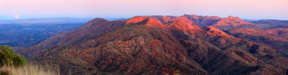
Once up to Sperm Whale Head and out in the open, we found there to be a stiff breeze blowing across the water, making it much cooler. We sight a couple of birds over Balfour’s Swamp as we walked past to the picnic area for lunch in the shade of a tree. Noticing a lot of large, fresh-looking cones on the ground beneath we relocated to another tree. These cones were big enough and falling from high enough to do some serious damage if they were to hit your head. Even under the tree we selected, we heard two cones fall to the ground during our lunch break.
After lunch Sue, having already run 10km today, started walking back to camp by herself. I wanted to have a bit more of a look around so added a few side tracks on the return. First I checked out the jetty and Point Wilson where there were a lot of seabirds resting. Next, I headed up over Murphy Hill where the added height allows some more distant glimpses of the landscape.
I walked back along the eastern side of Lake Killarney where you only get a clear view of the lake at the bird hide, although only one of the ports is clear of overgrowth. From here it was straight across Lake Victoria Track on Tree Fern Track which morphs into Murphys Swamp Track before rejoining Lake Victoria Track about 2km further on. The main advantage of the route was the firm ground underfoot which made walking much easier than on the vehicular track. These side tracks have also had the tractor slasher visit them recently so are quite wide.
Nearly back, just as it was starting to cool off a little the wildlife sighting picked up again. Within the final kilometre, I sighted a swamp wallaby and rosellas and wattlebirds feasting on the prolific banksia near Emu Bight. Just to finish the walk-off, there was a pair of Eastern Grey Kangaroos lazing around just behind our van!
Information on NSW National Parks signage along the way
Visitor Guide
The Lakes National Park is a peaceful bushland retreat in the Gippsland Lakes, fringed by Lake Victoria and Lake Reeve. Occupying 2,390 hectares of low-lying woodland and coastal heath, it consists of Sperm Whale Head peninsula, Rotamah and Little Rotamah Islands
Location and access
The Lakes National Park is in East Gippsland about 300 km east of Melbourne. The park is at the eastern end of Loch Sport, 63 km east of Sale. There is boat access from Paynesville.
Welcome to Country
On Friday 22 October 2010 both the Federal and State Governments formally recognised the Gunaikurnai people as the Traditional Owners of over 20 per cent of public land within Gippsland and Eastern Victoria. The Victorian Government and the Gunaikurnai people formally signed Victoria’s first settlement agreement under the new Traditional Owner Settlement Act 2010. This agreement involved the transfer of ten parks and reserves to the Gunaikurnai as “Aboriginal Title” which will be jointly managed in conjunction with Parks Victoria
The Lakes National Park is one of the jointly managed parks within Gippsland. This agreement recognises the fact that the Gunaikurnai people have always been connected to their land and are the rightful people who speak for that Country. These parks and reserves are cultural landscapes which are part of our living culture.
Things to see and do Picnicking The most popular of several picnic areas is at Point Wilson, the site of the original settler’s homestead. There are gas barbeques at Point Wilson as well as wood fired barbeques (BYO wood), a day shelter, toilets, water and a jetty. Fires are prohibited at Dolomite Swamp, Netting Boundary, Trouser Point and Cherry Tree, however gas barbeques are permitted
Camping Camping is only permitted at Emu Bight, close to the shore of Lake Victoria. A communal shelter and toilets are provided. Campers are required to bring their own firewood and water supplies. Fires may only be lit in the fireplaces provided and are not permitted on individual campsites. Bookings are required.
Plants and wildlife
Eucalypt and Banksia woodland are widespread in the sandy soils of the park. Areas of coastal heath are interspersed with swampy, salt marsh vegetation. During spring the park is at its best, with a spectacular show of wildflowers. Several rare plant species occur including Ribbed Thryptomene which, apart from this area, is found only in Tasmania and the York and Eyre Peninsulas in South Australia. More than 190 species of birds have been recorded in the park including the rare White Bellied Sea Eagle and the endangered Little Tern. You’ll also: see Eastern Grey Kangaroos, Black Wallabies, Echidnas and Wombats.
From past to present
The Gippsland Lakes were once part of a large bay. Over thousands of years, sands deposited by the sea formed a number of barriers, including Sperm Whale Head, Little Rotamah Island, The Ninety Mile Beach and Rotamah Island. These barriers, now up to 38m high, enclose the waters that make the Gippsland Lakes.
Aborigines of the Kurnai nation were numerous at the time of European arrival. The abundant wildlife and mild climate provided an ideal area to inhabit. In 1840, explorer Angus McMillan reached the shores of Lake Victoria, and soon after, cattle runs were taken up and much of the area now covered by park was cleared for grazing.
In 1927, through the efforts of the Barton Family and the Field Naturalists Club of Victoria, 1451 hectares on the Sperm Whale Head peninsula was reserved for the purposes of a national park, and proclaimed The Lakes National Park in 1956. Rotamah Island had a number of occupants until 1975 when it was bought by the Victorian Government. Rotamah Island and Little Rotamah Island were added to the park in 1978.
Lake Reeve Nature Trail & Lookout Tower– 30mins return
Lake Reeve provides important feeding and roosting habitat for a number of waterfowl species, and is one of Victoria’s most important areas for wading birds. The lake is a significant feature of the Gippsland Lakes system and is listed under the Convention on Wetlands of International Importance (RAMSAR). A short walk will lead you from the Lookout Tower car park down through a range of habitats to the shores of Lake Reeve. The numbers below denote the features along the nature trail.
Early beginnings
Start your walk at the Lookout Tower providing views of the Ninety Mile Beach and Lake Reeve. If you were here a few million years ago you would have been at sea. Over five million years ago the land to the north was pushed up to form the Great Dividing Range. It was only during the last million years that the Gippsland Lakes came into being. The lakes were formed when the sea deposited sand, creating a barrier which enclosed the bay that once existed here.
1. Open woodland
Much of the vegetation in the Park is woodland of Shining Peppermints and Saw Banksia. The main shrub here is the rare Ribbed Thryptomene, found here and in South Australia’s York and Eyre Peninsulas and in Tasmania.
2. Forests
This eucalypt is a Manna Gum featuring dark rough bark. This tree grows in wetter areas than the Shining Peppermint. The run-off water from the slope provides them with additional moisture. Manna Gum is one of the eucalypts which form the diet of koalas.
3. Wild Cherry tree
The Wild Cherry tree’s fruit begins to form from December to May. From July through to November the stem above the fruit swells to become fleshy red berries.
4. A change of habitat
This paperbark scrub is different from the other habitats you have walked through. Less light is able to get through the Swamp Paperbarks’ dense leaf canopy. Birds such as yellow robins, grey fantails and thornbills build their nests in the protection of the dense foliage.
5. The shoreline Wander
quietly to the edge of Lake Reeve and keep a look out for waterbirds. Black Swans, pelicans, grebes, ducks and cormorants are often seen feeding in these brackish waters. If you are lucky you may spot the rare White-bellied Sea-eagle as it hunts for prey.
The vegetation along the shoreline is salt marsh, bordered by plants such as the succulent glasswort. Its cactus-like shape helps it store water and salts. The lake shore vegetation has adapted to regular flooding and saline conditions
6. Location of former Grass tree
This was the location of an old Grass Tree (Xanthorrhoea australis). Grass trees are common throughout coastal areas; however, this particular tree was the only evidence that grass trees once existed in this section of the park.
7. Mystery tree Look above you.
This dead tree – otherwise known as a ‘stag’ – is covered in wounds. Each of the gnarled swellings in the branches is an attempt by the tree to block off a wound caused by either an insect or fungus. Even though the tree is dead, it still has an important role to play in this habitat. It provides home for many different animals – from possums through to insects.
8. Forest Red Gum This tree is not only magnificent but is estimated to be over 300 years old. See how the tree has formed a thick bark over an old wound. This is done to prevent any fungus or insects from attacking the tree. One can only imagine what the park looked like when this tree was a seeding.
9. Banksias
There are two types of banksia trees here. In front of you is the tall Coast Banksia which has a plain leaf edge with a white underside. Next to it is the Saw Banksia. As its name suggests, its leaves have a saw tooth, or serrated edge. Banksia flowers are an important source of food for Honeyeaters and Pygmy Possums.
10. Sheoaks
This tree is the Drooping Sheoak. These unusual trees have extremely small green drooping leaves which are really stems. This is thought to be an adaptation to cope with dry coastal conditions. The stems have a thick outer coating (cuticle) which helps lessen the water loss through evaporation
Rotamah Island Rotamah Island is a naturalist’s bushland delight. Accessible only by boat, the island is surrounded by Lake Victoria and Lake Reeve to the north and the dunes of Ninety Mile Beach to the south. A number of walking tracks leave from the picnic area and jetty. Camping is available to educational groups, but must be booked in advance through the park office
Walking Tracks 90 Mile Beach Walk (3.8km – 1.5 hours return)
From the jetty walk along the Causeway Track to the beach. Return via Fenceline Track and Lake Reeve Track.
West End Walk (4.8km – 2 hours return)
Starting at the jetty, follow the Causeway Track and West Track to the end of the island. Return via Melaleuca Track and Lake Reeve Track.
Rotamah Loop (7.6km – 3 hours return)
From the jetty and picnic area, follow East Track over the footbridge onto Little Rotamah Island. Return via Ocean Grange Track or the 90 Mile Beach to Causeway rack. Alternatively visit Ocean Grange by following the track down and back (additional 4.5km – 1.5-hour return)
East End Walk (4.6km – 2 hours return)
Follow East Track from the jetty and picnic area. This track offers some fantastic views before heading back along Forest Track.
The local flora, fauna, geology, history and some other walks (ChatGPT)
The Lakes National Park, a wondrous and pristine wilderness area located in Victoria that was once home to a stunning array of flora and fauna, shaped over thousands of years by the forces of nature.
The flora of this area was a mix of grasses, shrubs, and trees. The open grasslands were home to a variety of wildflowers, while the woodlands were dominated by eucalyptus trees, banksias, and acacias. The undergrowth was filled with a mix of ferns, mosses, and lichens, creating a lush and vibrant ecosystem.
As for the fauna, the area was teeming with life, both big and small. Kangaroos, wallabies, and wombats could be seen hopping and burrowing through the undergrowth, while birdwatchers could delight in the sight of cockatoos, lorikeets, and honeyeaters flitting through the trees. The waters of the nearby wetlands were home to an abundance of birdlife, including pelicans, swans, and egrets.
The geology of The Lakes National Park was shaped by the forces of wind, water, and time. The area was characterized by a mix of rocky outcrops, sandy beaches, and wetlands. The rugged coastline was home to a variety of interesting rock formations, while the wetlands were home to a unique mix of plant and animal life.
The history of the area is rich and diverse. The land was traditionally inhabited by the local indigenous peoples, who lived off the land and the waters of the lakes. European settlers arrived in the area in the mid-1800s, bringing with them a new way of life that would forever change the landscape and the ecosystem.
Today, visitors to The Lakes National Park can explore a variety of different walks and trails that showcase the natural beauty and cultural history of the region. The Emu Bight-Lake Victoria Track offers a chance to explore the wetlands and birdlife of the area, while the Sperm Whale Head walk takes visitors along the rugged coastline, providing breathtaking views of the ocean.
Other walks, such as the Murphy Hill and Tree Fern Track, take visitors through the lush and diverse woodland areas of the park, where they can see a variety of plant and animal life up close.
Overall, The Lakes National Park is a truly remarkable place, offering a glimpse into the natural and cultural history of this part of Victoria. While the flora and fauna may have changed over the years, the beauty and wonder of the landscape and the waters remain as awe-inspiring as ever.
Clickable icons on this world map will open the related trip report
A detailed, searchable trip list with links to reports, photo galleries and other content
![]()