
Monday 5/03/2023 Telegraph Saddle – Telegraph Junction – Little Waterloo Bay – Freshwater Creek – Little Waterloo Campsite
Wilsons Promontory National Park, VICTORIA
GunaiKurnai and Boonwurrung Country
Participants: Stephen Davies (Photos, Report), Sue Davies
A short drive up from Tidal River Campground had us at the relatively small Telegraph Saddle Carpark ready to start our walk. Yesterday, however, we noted the same road was closed and a shuttle bus service was operating from the Parks Victoria office carpark at Tidal River Campground. This is a weekend service to cater for the number of people wanting to start a walk from Telegraph Saddle.
Max elevation: 210 m
Total climbing: 962 m
Total descent: -963 m
Average speed: 4.60 km/h
Total time: 06:57:00
We were also informed by staff at the Parks Office of two major track closures due to very significant storm damage. These are the Sealers Cove Walking Track and Oberon Bay Walking Track. This is very unfortunate as it eliminates a possible day trip to Sealers Cove and any round trip via Oberon Bay.
With these limitations, we decided to aim for Little Waterloo Bay today before the forecast of wet and windy conditions tomorrow. We set off from Telegraph Saddle around 10:00am in heavily overcast, breezy conditions. The summit of Mount Oberon and other high peaks were under cloud and there were showers about. The walk to Telegraph Junction is somewhat tedious, as it is along a well-formed gravel road more suited to driving than old feet like to walk. Knowing full well we were in for a long day we kept up a good pace the whole way, only slowing occasionally to adjust our rain gear as the occasional heavy shower passed. With the damp and dull conditions, the forested slopes appeared very green today. We passed half a dozen so small groups of people walking out after overnight trips.
After 6.1km we turned east onto the Little Waterloo Bay Track where we were very pleased to find ourselves on a walking track as opposed to a road. Our old feet are much less pained by traversing a continuously varying surface than walking on any road. Along Little Waterloo Bay Track the vegetation changes a number of times, first through trees that are smaller than those along Mount Oberon. There are some ferny sections, including one with 2m high walls of fern on both sides of the track. Throughout this section, there are some wet boggy areas crossed by raised boardwalks. Approaching the beach it is much more open as the vegetation becomes very short with knee-high banksia mixed in with a number of different flowering plants. About halfway along Little Waterloo Bay Track there are some large granite tors not far up on the lower slopes of appropriately named Mount Boulder, one, in particular, resembling a scary face.

Granite tors above Little Waterloo Bay Track
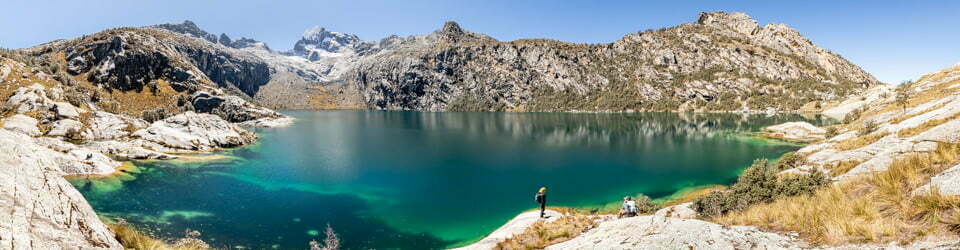
The track ends at Waterloo Bay, on a beautiful sandy beach, we took some photos here before heading north along the track to Little Waterloo Bay Campsite about 1km to the north. This coastal track is the most interesting and varied of our day as it weaves along the foreshore, and crosses Freshwater Creek where there are some fantastic granite tors on the beach’s end. The track crosses the creek and gains a few metres providing a great view back along the beach and its southern headland. The track from here to the campsite is now heavily treed and rougher than anywhere else on today’s walk.

Granite tors at Freshwater Creek on Little Waterloo Bay
Little Waterloo Bay Campsite is nestled in amongst the trees and has a number of tent sites spread out amongst them. Today we noted that recent rain had rendered pools of water in some of the campsites, so if you are pitching a tent here check the lay of the land first carefully if rain is forecast. Here there are also some benches, we selected one and ate our first lunch. The campsite is also just behind a small beach and has some granite tors at the end. We had some inside intel from people we had spoken to on the walk-in, they had found a little waterfall upstream of the freshwater tap, so we headed up to check that out as well.
We were very fortunate today as those early showers had dispersed and it remained dry for the rest of the day. Our return trip now underway we continued at a reasonable pace with a few more brief photo stops. Back near the granite face under Mount Boulder, we stopped for lunch two on a smooth granite “lookout”, this was very brief as it was now very windy.
From here it was just a long, tedious walk back the way we had come, except we were now beginning to tire and had the long 6.1km, gradual 250m climb back up to Telegraph Junction to finish the 25km day.
Information on NSW National Parks signage along the way
Welcome to Telegraph Saddle – Gateway to the Southern Prom
A Walk on the Wild Side
Telegraph Saddle is the starting point for a wide variety of walks suitable for beginners and experienced hikers alike. You can head out for the day, or camp overnight in the middle of paradise at any of the six overnight hike camp areas.
So put on some sturdy shoes and get ready to explore the rugged interior and wild coastline of the southern Prom.
Short Walks and Day Walks
All times and distances given are for one way travel.
1: Mount Oberon Summit 3.4 km, 1 hour
This iconic Prom walk follows the management vehicle track up Mount Oberon. Steps below the rocky summit lead to postcard perfect, panoramic views over Tidal River, the coast and offshore islands. Beware of unprotected cliffs.
2: Telegraph Saddle to Oberon Bay 9.5 km, 3 hours
Enjoy the rugged interior and dramatic views of the south west coast of the Prom as you walk through open forest and sand dunes to Oberon Bay.
3: Sealers Cove 9.5 km, 3 hours
One of the Prom’s most popular walks, the Sealers Cove track climbs steadily to Windy Saddle then descends through beautiful forests to the boardwalk over Sealers Swamp.
Overnight Hikes
An overnight hike is the perfect way to experience the incredible diversity of scenery found in the southern Prom and enjoy the wonderful feeling of remoteness in its beautiful secluded places. You will need to be reasonably fit, organised and well equipped to undertake an overnight hike.
Bookings are essential. Hikers must obtain an overnight hiking permit before commencing their hike and carry it with them at all times. On completion of hikes, permits should be returned to the Tidal River Visitor Centre or deposited in the permit boxes located at the Telegraph Saddle car park and outside the Tidal River Visitor Centre.
4: Sealers Cove camp via Telegraph Saddle 10.2 km, 3 – 3.5 hours
After completing the walk to Sealers Cove (walk 3), overnight hikers can continue their walk to Sealers Cove camp. Check tide times to avoid a deep water crossing of Sealers Creek at high tide. The camp is 50m on the south side of the creek.
5: Sealers Cove camp to Refuge Cove camp 6.4 km, 2 hours
The track traverses many vegetation types as it winds across Cape Wellington. The rise from Sealers Cove provides magnificent views across to Five Mile beach and the Cathedral peak. The campsite is at the southern end of Refuge Cove.
6: Refuge Cove camp to Little Waterloo Bay camp 7 km, 2.5 hours
From Refuge Cove, the track rises steeply through eucalypt woodland and a large open rock face. Stunning views across the east coast of the Prom are offered from the saddl near Kersops Peak before the track descends to Little Waterloo Bay.
7: Telegraph Saddle to Little Waterloo Camp via Waterloo Bay 11.9 km, 4 hours
After following Telegraph Track for 6.1km, turn left at Telegraph Junction. The track to Waterloo Bay weaves through sand dunes and swamps before reaching Waterloo Bay.
8: Little Waterloo Bay camp to Lightstation 10.9 km, 3 hours
Spectacular coastal views are provided as the track winds through the diverse plant communities in the foothills of the Boulder Range.
9: Lightstation via Halfway Hut and Roaring Meg 19.1 km
via Telegraph Track. 18.3 km via walking track sections. 5 – 6 hours
Perched on a small peninsula jutting out into the wild seas of Bass Strait, the Wilsons Promontory Lighthouse and its historic residences are the southernmost settlement on the Australian mainland. We recommend that you take a couple of days to soak up the rugged landscape, beauty and history of this area and stay overnight at one of the historic Lightstation cottages. Bookings are essential and can be made in person at the Tidal River Visitor Centre or by phoning (03) 5680 9555. Camping is not permitted at the Lightstation – the closest overnight hikers campsite is at Roaring Meg, a 6.1km walk from the Lightstation.
10: South Point 15.6 km, 5 hours
South Point is the southernmost point of the Australian mainland and offers dramatic views of Bass Strait and the Bass Strait Islands. The Point is accessed via Telegraph Track and Roaring Meg. Camping is not permitted at South Point – the closest overnight hikers campsite is at Roaring Meg, a 3.7km walk.
11: Tidal River via Telegraph Saddle and Oberon Bay 17.1 km, 5.5 hours After completing walk 2, enjoy spectacular views of the coast, Tidal River and the Prom’s offshore islands as the track winds along the coast via Oberon and Little Oberon bays to Tidal River. Beware of unprotected cliffs.
Welcome to Little Waterloo Bay Campground
Set between warm temperate rainforest, coastal dune scrub and grasslands, where Freshwater Creek flows across white sands into a crystal clear bay. A permit is required to camp here. Advanced bookings are essential and can be made online at parkstay.vic.gov.au or by calling Parks Victoria on 13 19 63
Landscape story
Wilsons Promontory National Park is part of an Aboriginal cultural landscape. Parks Victoria respects the deep and continuing connection that Traditional Owners have to these lands and waters, and we recognise their ongoing role in caring for Country.
Life in the fast lane
Periodically, you may see the enigmatic Dusky Antechinus (Antechinus swainsoni) around Little Waterloo Bay campground. Often confused for a rodent, it is a carnivorous native marsupial which forages on beetles, insect larvae, spiders and worms.
Antechinus produce the largest litters of all Australian marsupials, averaging eight to ten young. Mating occurs over a frantic two week period, after which the exhausted males die.
This is timed to ensure the young are born during the summer insect explosion.
Unlike most marsupials, antechinus do not have a pouch, instead the young attach to a teat and “hang on’ to the underside of their mother for up to 100 days. The litter can weigh up to four times the weight of the mother.
A bird’s-eve view
The Prom is a great place to observe Victorias birdlife. Around half of all Victorian bird species have been recorded at Witons Promontory. At dawn you may see or hear many small bird species around the campground. Walking the coast offers the opportunity to spot shore and sea birds fishing and feeding on abundant marine debris.
At home in the heathlands
Coastal heathlands can seem like harsh windswept places where soils tend to be nutrient poor. However, a diverse array of unique plants are well adapted to survive in heathland habitats.
Look closely to spot small exquisite orchids flowering seasonally throughout nearby heathlands. Between Little Waterloo Bay and Telegraph Junction you may see Pink Fingers, Rabbit Ears, Greenhoods, Rosy Hyancinth Orchids, and Slaty Helmet-orchids.
Orchids are deciduous and once they have flowered, only the tuberous roots remain hidden in the soil until next season.
This rich diversity of flora can be dependent on fire. Some native species re-sprout following fire, others, such as banksias, rely on fire to open their seed cases. Some orchids and grass trees respond with a proliferation of flowers.
Blue wilderness
The cool Southern Ocean meets the warm waters of the East Australian Current at Wilsons Promontory Marine National Park, making it home to some of the richest marine ecosystems off the coast of Australia.
A world class marine sanctuary
In 2002, the Victorian Government created a system of 13 marine national parks and 11 smaller marine sanctuaries to ensure representative samples of Victoria’s diverse and distinctive marine environments are conserved for future generations. These parks and sanctuaries now protect 5.3% of Victoria’s coastal waters, safeguarding important marine habitats and species, and complementing our world-class national parks system on land.
In October 2018, Wilsons Promontory Marine National Park received a Global Ocean Refuge System (GLORES) Award, recognising its science-based standards of effective marine park management. it is the first park in Australia, and only one of six in the world, to receive the Platinum Blue Parks Award.
This places Wilsons Promontory Marine National Park amongst the world’s best marine protected areas.
A kaleidoscope of colours
Wilsons Promontory Marine National Park protects a wide range of marine species, some of which are at the edge of their natural range in this park. These species come in an incredible kaleidoscope of colours.
In deeper water, purple Sea Tulips sway on their long stalks while filter-feeding, extracting plankton out of the water column; and white Hydroids feed on small planktonic animals using their stinging cells called nematocysts.
On the rocky shores, black Elephant Snail protect themselves using their large oval-shaped shell as body armour, Giant Cuttlefish, the most kaleidoscopic animal of all, can rapidly change its colours using adaptive camouflage to mimic the diverse, colourful reef environment that it lives in.
The striking Gorgonian coral
Attached to the reef in Waterloo Bay are colonies of Gorgonian coral. Mopsella imma is the most abundant species of Gorgonian coral found along the south-east Australian coast. The erect octocoral has eight hollow tentacles fringed with small appendages and the species thrives on the exposed reef, in water been 2 and 50 metres deep. A colony can grow up to one metre tall.
Gorgonian coral is made up of crystalline calcium carbonate, the main component of searchels. It is also made up of calcareous: scerites (a hardened body part, and a horn-like material called gorgonin. Gorgonian coral is classified as a colony because it is surrounded by hundreds of small living polyps called zookanthella. These polyps enable a means process of turning light into plant energy.
A colourful transformation
Endemic to the waters of south eastern Australia, Blue-throat Wrasse undergo a dramatic transition from female to male. changing their colour and appearance.
As juveniles, the females are nondescript, gaining a thick black and white stripe across their body as they mature. Each year some females will turn into males and develop a distinctive blue chin and yellow fins. The rate of transformation is dependent on the population of males.
Blue throat Wrasse aggressively compete with other fish species for breeding territories and feed on molluscs and crustaceans. Females favour seagrass and algal habitats on rocky rects whereas the males forage widely.
The species is vulnerable to fishing pressure as the large, territorial males are most easily taken. Females may transform into males reducing breeding success.
The local flora, fauna, geology, history and some other walks (ChatGPT)
Wilsons Promontory National Park, also known as “The Prom,” is located in Victoria, Australia and is part of the traditional lands of the GunaiKurnai and Boonwurrung peoples. The area has been an important cultural site for Indigenous Australians for thousands of years, and there is evidence of Indigenous occupation and use of the area dating back at least 6,500 years. The park is now jointly managed by Parks Victoria and the Gunaikurnai and Bunurong peoples.
The flora of Wilsons Promontory was incredibly diverse, ranging from towering eucalyptus trees to beautiful wildflowers that bloomed in a riot of colour during the spring months. The area was also home to a range of shrubs, ferns, and other plants that had adapted to the unique conditions of the region, including the harsh coastal winds and the occasional bushfire.
The fauna of Wilsons Promontory was equally diverse, with kangaroos, wallabies, echidnas, and wombats wandering through the underbrush, and emus striding across the open plains. The surrounding waters were home to seals, dolphins, and a variety of fish species, including the famous southern bluefin tuna.
The geology of Wilsons Promontory was shaped by millions of years of geological activity, including volcanic eruptions and glacial movements. The landscape was dotted with rocky outcrops, towering cliffs, and stunning beaches, each one a testament to the power of nature and the passage of time.
The history of Wilsons Promontory was just as fascinating as its natural beauty. The area was once home to indigenous communities, who had lived on the land for tens of thousands of years before the arrival of European settlers. The arrival of Europeans brought significant changes to the area, including the establishment of grazing and farming operations, as well as timber harvesting.
Today, Wilsons Promontory is a protected national park that offers visitors a chance to explore the stunning natural beauty and rich history of the region. The park features a range of different walks and trails, from short, easy walks that take visitors through the surrounding woodland areas, to challenging hikes that climb to the summit of some of the park’s highest peaks.
The Sealers Cove and Refuge Cove walks are particularly popular, taking visitors on a scenic journey through the stunning coastal landscapes of the park, where they can see a variety of plant and animal life up close. The park is also home to several campsites and accommodations, making it the perfect destination for a nature-filled vacation.
Overall, Wilsons Promontory is a truly remarkable place, offering a glimpse into the natural and cultural history of this part of Victoria. Its stunning beauty and unique ecosystem make it a must-visit destination for anyone who loves nature and wants to explore the wonders of the Australian landscape.
Clickable icons on this world map will open the related trip report
A detailed, searchable trip list with links to reports, photo galleries and other content
![]()