
Thursday 23/03/2023 Mallacoota Coastal Walk – Betka Road – Quarry Beach – Geology Point – Fishermans Track – Betka River – Betka River Estuary – Betka Surf Beach – Betka South Beach – Beach 8
Betka River Tourist Reserve & Mallacoota Coastal Reserve
VICTORIA
Bidawal Country
Participants: Stephen Davies (Photos, Report), Sue Davies
After a 6km morning run from our Bemm River campsite, we had our minds set on a relaxing day as we started to make our way home. As we drove towards our destination of Mallacoota, we were pleased to see the forests that were burned so badly during the 2019/20 bushfires showing plenty of new growth. During lunch, overlooking Bottom Lake, we reflected on our 2013 Nadgee-Howe Wilderness Walk and observed the small ferry that had taken us across Bottom Lake to Lake View Jetty for our start.
Max elevation: 21 m
Total climbing: 254 m
Total descent: -253 m
Average speed: 3.99 km/h
Total time: 02:15:59
After lunch, we decided on a short drive south along Bekta Drive to take in some of the lookouts and maybe walk to some of the marked sea caves. Our first stop at Quarry Beach piqued our interest, as we could already see some very interesting rock headlands at the end of the beach. Totally against any plans we had for the day, we put our sunscreen on and headed off.
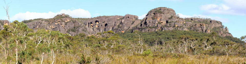
Unlike the overhyped rock formations of yesterday’s Pearl Point walk, today the unheralded geology of the headlands was easily the better and very different to anything we had seen recently at Wilson Promontory. With multiple layers of very colourful and varied rock twisted, folded and inclined at a variety of angles it created some wonderful patterns and shapes. Our rest day was transforming into an afternoon of delightful surprises. The sea cave we had come to see was almost forgotten.
So pleased with what we had seen on Quarry Beach we decided to walk the track above back towards Mallacoota. This also proved to be worthwhile as there are a couple of fantastic lookouts, including Geology Point, with views up and down the rocky coast. Very noticeable to the north are Cape Howe and Gabo Island with its 47m high lighthouse. Trackside all had been burned in 2019 but the new growth is very thick and around 2m high in places. I can’t image trying to walk through it!
In order to create a loop walk we headed towards Betka River on the Fishermans Track, taking us up to the Betka River Estuary about 1km away. Sue noted some Mellaluca and Acacia but also masses of dense, invasive weeds.
We were keen to see what the geology was like along the beaches at this end so now we walked the beaches instead of the track, something that would only be possible in many sections at low tide. Lucky for us it was.

Southern end of Beach 8
Again we were very impressed by the shapes and patterns that can be found as rocky mounds surrounded by sand or small headlands. We also met another keen photographer scouting the formations with his tripod and neutral density filters in hand, ready to create some memorable seascapes. With my tripod and filters in the van, I’d have to settle for my stock-standard snapshot approach yet again.
After walking as far as we could along the beach we were not very keen to return to rejoin the track at Betka River Estuary. I checked my maps and observed that we could rejoin the track from where we were with about 50m of bush regrowth to negotiate. So after our scramble up a small rocky headland, we headed through that very same seriously thick mainly weed regrowth we had seen earlier. For about 25m of that distance, our feet did not touch the ground at all, as we were supported by that very dense mat of undergrowth. Due to its very springy nature under our body weight, it proved very challenging to make progress as with every step it managed to snag your lead foot.
Once back on the track it was only a short distance back to our van. We were so glad we had reconsidered having that planned lazy day. The track, signage and lookouts were all in excellent condition having been replaced following the bushfires which devastated this area.
Friday 24/03/2023 Mallacoota – Bastian Point – Betka Beach
Prior to departing Mallacoota we did a very short coastal walk via the caravan park. Walking along the lake edge we first found our way to Bastian Point before p

Betka Beach from Bastian Point
oking our heads around the corner and viewing Bekta Beach from its northern end.
Information on National Parks signage along the way
Welcome to the Mallacoota Coastal Walk
This walk will take you on a fantastic journey of exploration along Mallacoota’s scenic coastline.
From here, the track hugs the top of the coastal escarpment to the secluded Secret Beach and Pebbly Beach, eventually leading into Croajingolong National Park.
Alternatively, you can walk back towards Betka Beach, where there is a short but very beautiful loop track along the banks of Betka River.
Lookouts along the way provide magnificent vistas of vast sweeping beaches and headlands, Cape Howe and Gabo Island.
Ancient Connections
Aboriginal people have occupied this area for thousands of years, and have cared for this land for countless generations. Their traditions and association with the land continue today in various cultural works and practices.
The names Mallacoota and Croajingolong derive from the local Aboriginal languages.
Coastal Wilderness This walk is part of a coastal wilderness route between Nadgee Nature Reserve in NSW and Sydenham Inlet. The 130km trek is suitable only for people who are fit, experienced and well-prepared. Camping permits are required for overnight walkers.
Rock – ancient and powerful forces at work
Turned to stone
These sedimentary rock formations were formed approximately 445 million years ago. They are characterised by layered strata of mineral and organic sediment that have gradually turned to stone.
These rocks reveal that this region lies within the remains of a subduction zone (where an oceanic plate slides beneath a continental plate), causing the earth to buckle into folds.
Rock layers of many different colours
They contain dark grey sandstone, quartzite, shale, slate and chert. The red layers derive from material rich in iron, the grey from organic material, and the white from quartz.
The layers of rock are generally parallel to the ground but the wave-like patterns are a result of folds and faults. Erosion and past quarrying have helped to reveal more of these impressive formations.
Blades and scrapers Some local rock such as chert and quartz was used by different groups of traditional Aboriginal people for scrapers, blades and grinding stones. The best material to use for tools was silcrete, which was traded and brought in from afar.
Ships and aircraft – coastal hazards and war
Torpedoes and sea mines
During the Second World War (1939-45), the nearby coastal shipping corridor was a prime target for Japanese submarines and sea mines.
Twenty-two ships were sunk off the south-east corner of Australia and two ships were sunk off Gabo Island including the Iron Crown, an iron ore carrier, with the loss of 38 lives.
RAAF base The RAAF established a major coastal surveillance base and airstrip at Mallacoota, which was supported by a radar station on Gabo Island.
Three bunkers were built to house the air navigation, wireless and Morse code equipment. Accommodation buildings were also erected. The area was a high-security zone, with approximately 60 personnel stationed there. Sentries guarded the Betka River bridge.
During their rest times, the men went to the beach and played sports. An old cricket pitch was recently discovered near here.
The underground bunker that was the headquarters of the Advanced Operations Base has been restored and established as the Mallacoota WW2 Bunker Museum. Visit the Mallacoota Visitor Information Shed for further information and bookings.
Turbulent waters
Three huge bodies of water meet
The Pacific Ocean, Southern Ocean and the Tasman Sea meet and merge here, producing immense ocean forces that cause huge waves and dangerous conditions.
Many shipwrecks have occurred on this coast despite the construction of the Gabo Island Lighthouse in 1862. This magnificent 47 metre tall structure was built using massive pink granite blocks, which were quarried on the island. It is the second-tallest lighthouse in Australia.
In 1998, competitors in the Sydney to Hobart Yacht Race sailed into a massive storm near Gabo Island, with enormous seas and waves that were more than 20 metres high. Five boats were sunk and six people died.
The relentless forces of the ocean The rocky headlands are made of sandstone, shale, slate and chert, which have been folded and buckled over millions of years by the immense geological forces. These hard rocks are gradually eroded away by crashing waves. Water also seeps into cracks that widen and deepen over time to form sea caves, which in turn eventually collapse to form gutters, islets and rock pedestals.
The local flora, fauna, geology, history and some other walks (ChatGPT)
Mallacoota Coastal Reserve is a pristine wilderness area located on the far eastern coast of Victoria, Australia. The reserve is situated on the traditional lands of the Bidhawal and Nindi-Ngudjam Ngarigu Monero people, who have lived in the area for thousands of years. Today, the reserve is managed jointly by the Victorian government and the indigenous community.
Geology:
The Mallacoota Coastal Reserve is primarily composed of rugged coastal cliffs, rocky headlands, and sandy beaches. The area is situated on the eastern edge of the Mallacoota Fault Zone, which is characterized by steeply dipping rock formations that have been uplifted and tilted by tectonic forces. The region’s geology is further shaped by the erosive forces of wind and waves, which have carved the cliffs and beaches into dramatic shapes and formations.
Flora:
The Mallacoota Coastal Reserve is home to a diverse array of plant life, including several rare and endangered species. The reserve’s vegetation is characterized by a mix of coastal heathland, eucalyptus forest, and wetland habitats. Some of the most notable plant species in the reserve include the Mallacoota Wattle (Acacia podalyriifolia), the Mallacoota Grevillea (Grevillea alpina), and the Dwarf Mountain Pine (Pherosphaera fitzgeraldii).
Fauna:
The Mallacoota Coastal Reserve is also home to a rich and diverse array of wildlife, including many species that are unique to the region. Some of the most notable animal species in the reserve include the Southern Right Whale, the Australian Fur Seal, the Eastern Barred Bandicoot, the Sooty Oystercatcher, and the White-bellied Sea Eagle. The reserve is also home to a number of reptile and amphibian species, including several types of lizards, snakes, and frogs.
Indigenous History:
The Mallacoota Coastal Reserve has been an important cultural and spiritual site for the Bidhawal and Nindi-Ngudjam Ngarigu Monero people for thousands of years. The indigenous community has a deep connection to the land and the sea, and their traditional knowledge and practices have helped to shape the region’s ecology and biodiversity. The reserve is home to a number of significant cultural sites, including shell middens, rock art, and burial grounds.
White History:
European settlement of the Mallacoota region began in the mid-19th century, and over time the area became an important site for fishing, logging, and farming. In the early 20th century, the region began to attract tourists, and today the town of Mallacoota is a popular holiday destination. The establishment of the Mallacoota Coastal Reserve in 1980 marked a significant milestone in the conservation of the region’s natural and cultural heritage.
Walks:
The Mallacoota Coastal Reserve offers a variety of walking trails that showcase the region’s natural beauty and biodiversity. One of the most popular walks is the Wilderness Coast Walk, which spans 100 kilometres from the eastern edge of the reserve to the Victorian-New South Wales border. The walk takes hikers through a variety of coastal habitats, including heathlands, forests, and wetlands, and offers stunning views of the coastline and surrounding landscape. Other popular walks in the reserve include the Betka Beach Trail, the Mallacoota Inlet Walk, and the Secret Beaches Walk.
Clickable icons on this world map will open the related trip report
A detailed, searchable trip list with links to reports, photo galleries and other content
![]()