
Tuesday 20/10/2020 Burbie Canyon – Burbie Fire Trail – Danu Gap – Mount Exmouth – Cathedral – Arch
Warrumbungle National Park, NSW
Kamilaroi country
Participants: Stephen Davies (Photos), Sue Davies (Report)
For today’s adventure we decided to scale the highest peak in Warrumbungle National Park, Mount Exmouth. This begins with a pleasant 1km stroll through Burbie Canyon, which at this time of the year is carpeted with wildflowers.
Max elevation: 1169 m
Total climbing: 1987 m
Total descent: -1986 m
Average speed: 4.05 km/h
Total time: 08:00:26
After exiting Burbie Canyon the uphill slog along Burbie Fire Trail commenced. About half way up to Danu Gap a National Park Ranger passed us in his four wheel drive. He was checking fox traps but wasn’t too interested in our reports of sighting goats yesterday. He informed us that national parks undertook four aerial shootings of such feral animals in Warrumbungle National Park each year. We did not see him again so he must have continued along the fire trail over the other side of Danu Gap.
We pushed on past Burbie Camp which was just a small open flat area, like most of the other remote campsites we had previously come across. As there was no water source nearby a lot would need to be carried in with you if you were planning to camp there or beyond.
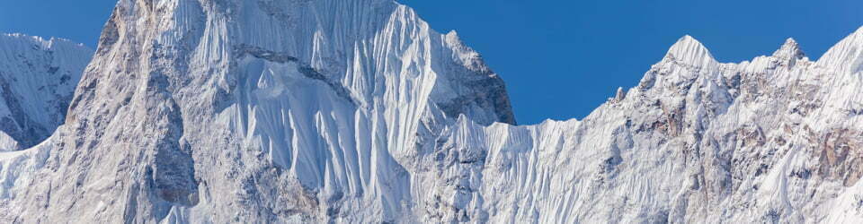
At Danu Gap, another very small campsite was observed, there is definitely no water here on top of the ridge. From Danu Gap the sign points westward towards Mount Exmouth. The peak looms high above but the 2.6km climb is gradual and too not taxing. Along the slopes before not far before the final summit climb was the most impressive stand of grass trees we have ever seen. There are hundreds thriving over a wide area.
Once on the summit of Mount Exmouth there are still more grass trees but here they were more widely spread. From the top we looked down on The Breadknife, Bluff Mountain and many of the features that we had walked on or past yesterday. To this point we had it all to ourselves, or so we thought.
Just as we started descending from our exploration of the summit plateau we met another couple heading up. The woman said she was exhausted from the climb and joked that she was ready for a sky burial! Not far behind this pair were about twelve other people altogether in a couple of parties. At least we had enjoyed some solitude whilst we were on top.
Back down at Danu Gap we decided to take the “980m” (according the National Parks sign) one way side trip to look at the Cathedral and Arch. We were very glad we did as even the track leading up to Cathedral and Arch was interesting, passing across a huge scree slope initially before arriving at great views of basalt formations to the east along Dows High Tops on the other side.

Arch past Danu Saddle
Turning south around the corner we found “The” Cathedral, which I assumed was an area of interesting weathered pagoda style rocks that you walk through on the way to The Arch. The Arch itself was larger than expected and has a tree growing out from it’s top. This was definitely worth the short side trip.
Our long descent back along the Burbie Fire Trail was uneventful except for sighting two goannas alongside of the trail. The one climbing a tree proved to be very cooperative and photogenic.
Another long but thoroughly enjoyable day walk.
NSW National Parks signage along the way states
Mt Exmouth (via Burbie Fire Trail)
“Grade: moderate to steep Distance: 17.3 km return Time: 5-7 hr Start: Split Rock Car Park
The less rigorous of the two walks to Mt Exmouth if you don’t mind following a fire trail. Look out for koalas along the ambient tree-lined section known as ‘The Boulevard.”
Mount Exmouth via West Spirey Creek
“Grade: steep (fit, experienced walkers only) Distance: 16.8 km return Time: 5-7 hr
A long, demanding but extremely rewarding trek to the highest peak in the park. Pass some delightful stands of grass trees and enjoy expansive views in every direction. Make sure you are well prepared. Don’t miss the short detour to Cathedral and Arch.”
Wednesday 21/10/2020 Whitegum Lookout
Warrumbungle National Park, NSW
With our exploration of the walking trails in Warrumbungle National Park over, we pulled into the Whitegum Lookout Carpark and took the short walk to the lookout for one last look at the mountains before driving off to Goulburn River National Park.

View from Whitegum Lookout
NSW National Parks signage at Whitegum Lookout states
“Easy sealed path suitable for wheelchairs and prams Distance: 1 km return Time: 30 min
Start: Car park off John Renshaw Parkway
Whitegum Lookout is perched on the eastern rim of the park and overlooks the entire range.
After a day’s walking, it is a memorable place to enjoy the sunset behind the mesmerising Warrumbungle Mountains.
This lookout offers one of the best views of the park’s impressive volcanic landscape. Rising majestically out of the vast plains, the mountains have been a meeting place for Aboriginal people for thousands of years.
Around 35 million years ago, as the Australian continent drifted north, it moved over a fixed spot in the Earth’s mantle where magma from deep below was pushing up into the Indo-Australian Plate.
The first place this ‘hot spot’ broke through was at Cape Hillsborough in northern Queensland where it formed a volcano. As Australia continued to drift northwards, magma burst through series of weak spots forming a chain of volcanoes that run the length of the continent.
The Warrumbungle volcano began to form around 17 million years ago with intermittent eruptions for more than three million years. It pushed through the ancient Pilliga Sandstones that were laid down when much of Australia was covered by inland seas. Over millions of years, erosion of the softer rocks has left an amazing landscape of the solidified vents (plugs) of the volcano, lava domes and flows, dykes and other volcanic formations.
Some of the spectacular features you can see from here are The Breadknife (a narrow 90 metre high dyke that stretches for half a kilometre), Bluff Mountain (a trachyte lava dome with a near-vertical face 250 metres high) and Belougery Spire (a plug with horizontal trachyte columns).”
Clickable icons on a world map which open the related trip report
A detailed, searchable trip list with links to reports, photo galleries and other content
![]()