
22/04/2019 – 1/05/2019 Jagat – Dharapani – Chame – Upper Pisang – Manang – Yak Kharka – Thorong Phedi – Thorong La Pass – Muktinath – Kagbeni
Annapurna Circuit, NEPAL
Distance: 172km Total Ascent: 10,400m Total Descent: 8,670m Time: 68 hours
Participants: Subin Basnet (Porter), Pawan Dai (Assistant Guide), Stephen Davies (Photos), Sue Davies (Report), Giorakh “Kaka” Dulal (Porter), Prabin Karki (Guide), Ralston Keyt, Sarah Keyt, Mohan Khaimrange (Porter), Sonaiya Magear (Assistant Guide), Amanda “Mandy” Menheere, Ravi lal Phuyal (Porter), Kerrie Stewart, Lisa Stewart, Kaitlin “Kitty” Travers
The Annapurna Circuit is considered one of the world’s best long distance treks. It is located within the mountain ranges of central Nepal and it encircles the Annapurna Massif. It offers a wide variety of climatic zones from tropical vegetation at 600m to the chilling alpine conditions of Thorong La pass at over 5,400m. There are cultural varieties from the Hindu villages at the lower elevations to the Tibetan culture of the Manang valley.
We travelled with the assistance of guides and porters from Himalayan Encounters, a company based in Kathmandu.
Expect stunning high altitude scenery, comfortable tea houses and delicious (mainly vegetarian) freshly cooked food.

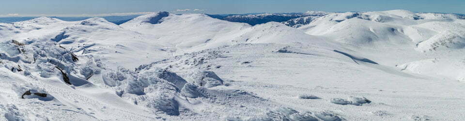
Map of our planned trek from Jagat to Jomsom at Tilicho Hotel & Restaurant
Our trip from Kathmandu to Jagat was relatively uneventful. No flat tyres, no bogged buses, fish tailing on slippery roads and no camping with the local villagers after becoming stranded (which happened at the start of our trek last year)! We spent six hours on a bus to Besisahar and then three hours crammed in a jeep to Jagat where we spent the night in a lovely teahouse where we were lucky to have an ensuite! Luxury!
Day 1: Monday 22/04/2019 Jagat (1300m) – Dharapani (1860m)
Max elevation: 2491 m
Total climbing: 8693 m
Total descent: -8031 m
Average speed: 14.31 km/h
Total time: 08:24:56
We were woken to the sounds of dogs barking, roosters crowing and the smashing of rocks. It was a lovely clear morning as we left the village and we were brimming with anticipation of the adventure that awaited us.
We were thrilled to find out that most of our team from the previous year, Kaka and Ravi as porters and Pawan who was now an assistant guide had returned to join us.

Ready to start the Annapurna Circuit, Tilicho Hotel & Resturant
We descended to the river amongst the lush green vegetation and crossed the first suspension bridge of the trip. The steep sided valley was gorgeous with waterfalls cascading into the river below.
It didn’t seem long until we reached the level plain of Tal where we passed a wedding celebration. Pumpkin curry, corn bread and masala tea awaited us. This section was a repeat from the previous year and the lunch was just as good as we remembered. It was so delicious and filling! Tal is a picturesque village with colourful teahouses and waterfalls cascading very close by.
With full bellies we headed off for our afternoon walk. We continued up the valley along the river. We crossed over the river and continued along the road for what seemed like several hours before we saw the welcoming sign of Hotel Heaven. We laughed as we had been to this hotel at the end of our Tsum Valley / Manaslu trek last year. We thought it was heaven, an oasis of luxury. While it was comfortable it was not all that good! It is an indication of how basic our accommodation had been on that trip.
Just before reaching the hotel we had to cross a stream of water on the road from an overflowing waterfall.
Day 2: Tuesday 23/04/2019 Dharapani – Chame (2670m)
Max elevation: 2759 m
Total climbing: 3069 m
Total descent: -2334 m
Average speed: 4.49 km/h
Total time: 08:37:58
The morning started with the promise of a fine day with the surrounding peaks tempting us with glimpses. These were “real mountains”, over 6,000m including Manaslu.
We were walking on roads for some of the day and then heading off on the occasional “short cut”. We came to a beautiful waterfall and the forest around it appeared to have autumnal coloured foliage except it is spring.
We then climbed for about an hour to our morning tea stop and enjoyed a lemon, ginger and honey tea.
Contining on we passed apple orchards in blossom until we reached our lunch destination where we enjoyed vegetable momos and we bought dried apple that had been grown and dried at the tea house. In the afternoon we enjoyed glimpses of the peak of Annapurna 2.

Monks at Koto Monastery
The terrain in the afternoon was undulating and the cloud lowered over the peaks. We reached a monastery and we were invited inside while the monks were reciting prayers and playing horned instruments. Outside we were offered masala tea (if you don’t accept it they think you don’t like the monastery). The children were feeding a pet rat, there was a mute old man who was well looked after and we saw a toddler playing with a mobile phone. He didn’t seem to have the wifi issues we experienced. Sarah gave the children pencils and they skipped away happily. A short time later we reached the village of Chame. We then walked to the local hot spring where some of our group braved the very hot pool.
That evening we enjoyed the best vegetarian pizza and momos in Nepal.
Day 3: Wednesday 24/04/2019 Chame – Upper Pisang (3300m)
Max elevation: 3674 m
Total climbing: 4189 m
Total descent: -3606 m
Average speed: 10.13 km/h
Total time: 08:13:27
After enjoying a delicious breakfast and sadly hearing about an earthquake this morning in Kathmandu we headed off on a glorious spring morning. We enjoyed wonderful views of the peak of Lamjung Himal as we continued up the valley. We walked though a lovely fir and pine forest with the pine needles soft under our feet. We were astounded to see the incredible rock slab structure called Heaven View and we heard a huge avalanche high off Annapurna II.
We stopped for morning tea at Bhratang and were astounded to see a huge modern western style hotel (but we were very excited about the flushing toilets) and a cafe selling cappuccinos, lattes and apple donuts!
The weather afforded us stunningly clear views as Annapurna II revealed itself in all it’s glory. We saw Siberian ducks flying over a lake on their migration route. If only Steve was quick enough with the camera.

Annapurna Himal from near Bhratang
The scenery just got better in the afternoon and drink stops also entailed mandatory dancing to Nepali music. How the porters have the energy to dance after hauling 30kg loads and still be so joyful is remarkable.
After settling into our accommodation in Upper Pisang we walked up to the monastery with panoramic views of Annapurna II in the evening light. Lots of photos and selfies were taken. It was an excellent day.
The best aspect of our accommodation was the surprisingly fast wifi. We could upload photos, facetime family and download the newspaper. Other aspects of the accommodation were not so favourable, particularly the blocked toilet.
Day 4: Thursday 25/04/2019 Upper Pisang – Manang (3540m)
Max elevation: 3780 m
Total climbing: 2228 m
Total descent: -1964 m
Average speed: 3.49 km/h
Total time: 10:42:27
We awoke to incredible views of the sun’s early rays on the peak of Annapurna II with the moon rising. Several of us were feeling the effects of the altitude including disturbed sleep and breathlessness. As the day’s walk started with a climb the pace was very slow. We had a long slow climb up to our morning tea stop.

Annapurna II from Upper Pisang
We enjoyed panoramic views of the Manang Valley and Tilicho peak on a stunning spring day. The weather gods were really on our side as we enjoyed this weather and clear skies all day. We were treated to views of many of the Annapurnas today, II, III and IV. The sun was very strong and we needed to reapply sunscreen. Combined with the effect of the strong winds there were many red cheeks in the group.
We stopped for lunch at a lovely tea house where Sarah enjoyed yak curry and we were given complimentary vege curry. The owner’s mother was 90 years old and generously allowed us to take photos of her.
The afternoon walk was through dry and desert like conditions with wind and dust, particularly when jeeps passed by. It was a long haul along the road until we finally reached the scenically situated Manang at about 6:00pm. From here we had excellent views of Annapurna II, III, IV, Gangapurna and Tilicho peak. Following an excellent meal of non-Nepali food we crashed into bed.
Day 5: Friday 26/04/2019 Manang (3540m)
Max elevation: 3964 m
Total climbing: 1379 m
Total descent: -1378 m
Average speed: 2.95 km/h
Total time: 04:38:35
It was a treat to have a sleep in and not to have to pack up today. Our goal was an acclimatisation walk so we set off after breakfast to visit a small monastery high above Manang. Again, we were treated to stunning spring weather and clear mountain views. Our walk was slow and steady, gaining altitude and resting. The views along the way of the Annapurna range, Gangapurna Lake and the Manang valley were impressive.

Annapurna III (7555m) and Ganggapurna (7454m) and Ganggapurna Tal from above Manang
We stopped for morning tea and out came the Nepalese music and the dancing started. It is such a joyful thing to do with a stunning mountain backdrop.
We eventually reached the prayer flags and the small 700 year old monastery. The 71 year old Buddist nun gave each of us a blessing, a woven necklace and tea. She wished us good health and safe travels. It really was a moving experience. The necklace would bring us good luck and could be worn on the wrist but if it was worn on the ankle it would bring us sickness. We should not throw it out, if not wearing it we should keep it at our homes.
Unfortunately for Sarah despite the blessing she didn’t make it out the doorway without hitting her head on the door frame. She is clearly too tall for this country.
We descended back to Manang to enjoy lunch and a rare free afternoon to rest up in preparation for pass day. We enjoyed a cappuccino, hot chocolate and cookies at a western style coffee shop. No complaints from us.
In the evening we were entertained by a Russian group who performed group self massage and a relaxation session. We got the giggles.
Day 6: Saturday 27/04/2019 Manang – Yak Kharka (4050m)
Max elevation: 4035 m
Total climbing: 1512 m
Total descent: -1005 m
Average speed: 3.41 km/h
Total time: 05:46:09
We left Manang under incredible blue skis yet again. We passed the Mani walls, spinning the prayer wheels for good luck. This was a daily ritual. A family group including children were planting potatoes. Leaving Manang we enjoyed expansive views as we bade farewell to the Annapurna range. We now left roads and vehicles and watched the farmers ploughing their fields with a yak powered wooden plough.
I saw a Himalayan golden weasel scurry across the path in front of us.
Morning tea was enjoyed at the village of Gunsang. We had 360 degree views of the mountains and to top it off a group of vultures soared on the thermals above us. Mandy and Steve were snapping photos madly.

Annapurna Himal from near Ghusang (Gunsang)
We had several stops for impromptu dancing to Nepali music which slowed our progress but it was so much fun! A few people attempted to lift the porter’s load. No one got very far but Mandy did really well. We have great respect for our porters.
In the afternoon we saw large flocks of blue sheep and more eagles. We followed the river valley with spectacular views all the way including the approaching Yak peak.
Acclimatisation Walk
Max elevation: 4151 m
Total climbing: 298 m
Total descent: -298 m
Average speed: 2.38 km/h
Total time: 02:00:35
We arrived at Yak Kharka around 2.00pm and enjoyed a late lunch. In the afternoon we climbed a hill behind the village for our acclimatisation walk. We had great fun doing photo shoots with the stunning mountainous background. The porters got really involved even down at Upper Yak Kharka on the return journey. The was lots of jumping shots.

Our party near Yak Kharka
We enjoyed dinner at the Gangapurna Hotel.
Day 7: Sunday 28/04/2019 Yak Kharka – Thorong Phedi (4525m)
Max elevation: 4546 m
Total climbing: 1280 m
Total descent: -755 m
Average speed: 3.60 km/h
Total time: 04:00:37
We awoke to yet another stunning morning and we were hoping the weather would hold out for just two more days. Leaving Yak Khaka we enjoyed scenic views all the way.
At a rest stop Prabin (our guide) told us about how at the age of 9 years he was taken from school by Maoists during the Maoist uprising. He was forced into a training camp and taught how to use a gun. He escaped, was put into gaol and remained there for some time until his cousin rescued him. He bears no animosity to his captors. The Nepali philosophy appears to be not to dwell in the past but to move on. In the present day the Maoists have a power sharing agreement with the communist party and he feels this arrangement is of benefit to the Nepali people. He is such a positive happy person given his childhood experience.

Kone Khola
We climbed a ridge gradually and then descended to the headwaters of the Marsyangdi Nadi and crossed the river on a small wooden bridge. We ascended by the river and needed to take care past an unstable scree slope, there was no stopping and we kept 50m apart but each person was accompanied by a guide or porter. We were pleased that everyone made it through safely, albeit with a lot of huffing and puffing!
It wasn’t long after this that we were happy to see the buildings of Thorong Phedi. The Nepali army were doing a training exercise here so were were greeted by men in combat fatigues holding semi automatic machine guns and some with rocket launchers!
Acclimatisation Walk
Max elevation: 4781 m
Total climbing: 797 m
Total descent: -797 m
Average speed: 2.94 km/h
Total time: 01:44:06
After lunch we went on our final acclimatisation walk, an hour above Thorong Phedi. We had an early night in preparation for pass day tomorrow.
Day 8: Monday 29/04/2019 Thorong Phedi – Thorong La Pass (5416m) – Muktinath (3760m
Max elevation: 5412 m
Total climbing: 1789 m
Total descent: -2614 m
Average speed: 3.05 km/h
Total time: 11:09:49
After so much anticipation it was pass day! We awoke at 3:00am for a 4:00am departure. No-one got much sleep especially Kitty and Mandy who had mice in their room.
We had a light breakfast, collected our packed lunch and soon we were on our way. The trail leaving the teahouse was steep and we were just putting one foot infront of the other using our head torches, huffing and puffing up the hill. The stars were stunning with a sliver of a moon. This trail had been used by local people for hundreds of years so it is well defined.

Infront of Gundang (5312m) above Thorung Phedi
It didn’t seem long before we reached upper camp just as the sun’s rays were giving a glow to the peaks. We saw Venus rising and we couldn’t believe our luck to have clear conditions for the pass. It was absolutely stunning.
We continued to climb, sometimes walking on snow with quite a drop off to the side. After another 1.5 hours we reached the high teahouse where we could purchase water for the last time. It is recommended not to visit the toilet here!
The trail levelled out somewhat after the tea house but any incline was very difficult at this altitude. After about five hours of climbing we finally reached the chorten and prayer flags of the pass at 9:00am. It was exhilarating and we were so happy that everyone had safely made it to the pass. We had to line up for our photos at the sign but after about half an hour and not wanting to linger at 5416m of altitude we commenced our descent. Thorong La is considered the biggest pass in the world in terms of time spent above 5,000m as it has a gradual approach and descent. Sarah and Steve did very well being the only ones in the group (apart from the Nepalis) who did not take Diamox for the altitude.

Our party celebrating at Thorung La Pass (5416m) – “World’s Biggest Pass”
As we left the pass the scenery changed almost immediately to more barren desert like conditions. The descent was quite gradual which meant we spent several hours above 5,000m and the effects of altitude became apparent with several of us. It was a long descent to Muktinath, 1,600m vertical and it was very fatiguing considering we had so little sleep.
Eventually we arrived at the bustling town of Muktinath which has a famous Buddhist temple that people travel long distances including from India to visit. It is considered good luck to run under the water taps which several of our party did.
Our accomodation was luxurious by Nepali standards with a hot shower (either very hot or very cold), a sit down toilet and a towel! We had a party at night as two of our party, Mandy and Kitty would leave us at lunch time tomorrow.
Day 9: Tuesday 30/04/2019 Muktinath – Kagbeni (2810m)
Max elevation: 3678 m
Total climbing: 273 m
Total descent: -1110 m
Average speed: 3.81 km/h
Total time: 03:29:48
Everyone was feeling better this morning, being at a lower altitude. After a more leisurely breakfast we walked through the market area of Muktinath with people selling scarves, beanies, gloves and coconuts. We descended the dramatic Kali Ghandaki gorge through barren desert like conditions which is apparently similar to Tibet in terms of geography and climate. We were surprised to walk on a well maintained paved road, most likely built for access to the monastery. We passed through the villages of Jharkot and Khinger with typical Tibetan architecture.

Jharkot
On the way down we met two Indian Saddhu (Hindu holy men) who had walked from southern India. They were pretty happy and told Sarah not to worry, God would help her with her descent. They were relaxed and smoking happy weed.
We continued a fairly steep descent and came over a ridge to look down on Kagbeni. It looked like a green oasis in the middle of the desert. This area is very dry and windy, typically the wind picks up at 11:00am and today it was on cue. People living here follow the Tibetan lifestyle and culture. There is a monastery from the 15th century.
We had lunch and settled into our relatively modern accommodation. We said farewell to Kitty, Mandy and Sonaiya who had been excellent travelling companions. We enjoyed a relaxing afternoon inside as it was extremely windy and dusty outside.
Day 10: Wednesday 1/05/2019 Kagbeni (2810m)
Today was our long anticipated rest day but we still awoke early as usual. The mountains revealed themselves nicely with the clear morning skies. The rich green of the irrigated farming fields were a stark contrast to the surrounding barren hills.

Kagbeni
After breakfast Steve, Sarah, Ralston and I wandered down to the river to look for fossils. The river would be excellent for grey water rafting. It was disappointing to see so much rubbish, particularly plastic bottles.
At mid morning we all headed to the local monastery which cost 200 rupees to enter. We were allowed to take photographs inside the new monastery and outside the old one but not inside the old monastery. We learnt about Buddha and the different branches of the religion.
We then went for a walk around town and walked through the old town which had very primitive construction with rocks and woods. The houses store bundles of wood on their roofs which is apparently for future cremations. This is also an area which still practices sky burials. The deceased person is carried high on a mountain top, chopped into pieces and the eagles carry away their body parts. We decided this was not a good place to pass away!
There was a mud woman on a wall and a male structure with a very large penis which was meant to protect the town from evil spirits and ghosts.
We spent a relaxing afternoon inside as the wind and the dust whipped up.
Kagbeni marked the end of the Annapurna Circuit component of our extended trek. Steve, in particular, was very satisfied to have reached this point as his 1985 attempt was an epic failure. From here we spent another ten days trekking through the desolate, high altitude Upper Mustang Valley amongst very different scenery.
Clickable icons on a world map which open the related trip report
A detailed, searchable trip list with links to reports, photo galleries and other content
![]()