
25/6/2019 – 28/6/2019 Vaqueria – Quebrada de Paria – Taulipampa – Llamacorral – Cashapampa
Santa Cruz Hike, Corderilla Blanca, PERU
Distance: 82km Total Ascent: 8,500m Total Descent: 9,300m Time: 25 hours
(Inaccurate distance & ascent/descents due to gps reception errors during day 3)
Participants: Stephen Davies (Photos), Sue Davies (Report), Elva Marcos Campos (guide), Emilio Gloria Arevalo (cook) Javier valdivia Melo (donkey driver)
This is a popular walk in the Corderilla Blanca and can be organised through several trekking companies or walked independently. There are buses that travel to the trailhead. This is a stunning mountainous area of Peru yet it is in the tropics about 9 degrees south of the equator.
Day 1: Tuesday 25/6/2019 Vaqueria – Quebrada de Paria
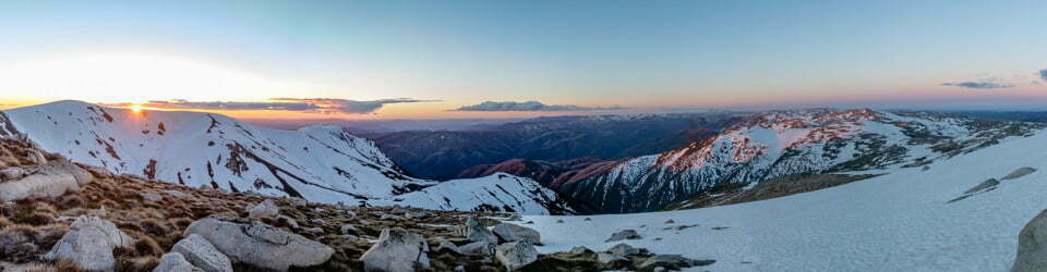
Lush green valleys and stunning snow capped peaks
Max elevation: 3896 m
Total climbing: 1825 m
Total descent: -1668 m
Average speed: 5.28 km/h
Total time: 05:14:35
It was another early start for us with a 5:00am pick up. We were keen with anticipation for our four day trek. It was a long drive to access the trailhead. We stopped for a quick breakfast and then continued on for what would have to be one of the most scenic drives we had ever done. It was a long and winding dirt road but the views just got better the higher we climbed. About half way up we had great views of Laguna Chinacocha and Laguna Orgoncocha (the male and female lakes) with the stunning peaks against the deep blue sky.

Nevados Huandoy from Port. de Llanganuco (On drive to Vaqueria)
Up and up we climbed until we reached the pass at Port de Llanguanco at 4767m. It was time for group photos with our crew against the panoramic backdrop.
We continued on to the village of Vaqueria, our starting point for the trek. Our travel time was about five hours including stops.
It was great to start walking in the warm sunshine, even better that it was downhill! We followed a beautiful lush green river valley with extensive farming in the fertile soils. We saw domestic animals, cows, sheep, donkeys, alpaca and llamas. We had excellent views of a pyramid shaped mountain, Chacraraju Oeste, against a crystal clear sky.

Chacraraju Oeste (6112m) from Rio Yurma
We had a snack stop at the Santa Cruz ranger station where we needed to complete our details. We continued along the valley where we found a lovely spot for lunch which Emilio had kindly carried for us. It was a local dish of chicken and rice which was delicious! I even got to have a coffee so everyone was happy.
We continued on at a relaxed pace and I was surprised when we reached our lovely campsite at Quebrada de Paria (3,825m). Here we were the only campers other than some resident cows. Our tents were already set up for us and we spent the afternoon relaxing, drinking cocoa tea and preparing for pass day tomorrow.
Emilio our chef cooked us an amazing meal in the evening. He must be the only one in the world who thinks we don’t eat much!
Day 2: Wednesday 26/6/19 Quebrada de Paria – Taulipampa (4250m)
Where did all the oxygen go?
Max elevation: 4758 m
Total climbing: 1615 m
Total descent: -1279 m
Average speed: 2.96 km/h
Total time: 08:16:27
It was a very chilly night but we managed to sleep well even though Steve was up and down doing star trail photography. It was a chilly morning when we headed off quite rugged up but Steve stripped down to shorts on the first hill. I was still wearing my down jacket.
Up and up we climbed as you would expect on pass day. There were some clouds and mist around which partially obscured our views but it added to the atmosphere. We had good views of the alpine lakes, Laguna Huishcash and Morococha which were a bit reminiscent of Tasmanian scenery. We saw a rare alpine flower which the locals use to make a tea for their children to help them to speak.
Steve was really struggling with the ascent and was very breathless, having to stop almost every few paces. We were ecstatic when we reached the pass, Punta Union at 4750m? The views on the other side where it was clear were astounding.

Sue and Alva at Punta Union (4750m)
The blueness of Laguna Taullicocha backed by Taulliraju mountain was literally breathtaking. We were so lucky the weather had cleared so we could savour the views. We took lots of pics and had lunch just below the pass. The sun even warmed us for a while. Emilio impressed us yet again with a traditional Peruvian dish of chicken, sweet potato and a thick chilli gravy. It was delicioso!!
We then started our descent and the views just seemed to get better and clearer. We arrived at camp after about eight hours of walking and the campsite was everything Elva had promised, stunning views of mountains and glaciers in all directions.
We were given hot water and a washer for an afternoon clean up in the warm sunshine. A bit later it was tea time where for a snack we were offered freshly made parsnip chips and home made guacamole. Oh my goodness we felt so spoilt!
In the evening we had our standard three course meal of quinoa and potato soup, vege stir fry with rice and a strawberry desert, everything made from scratch by Emilio. Delicioso!
Day 3: Thursday 27/6/19 Taulipampa – Llamacorral
Lupins and Towering Peaks
Max elevation: 5045 m
Total climbing: 3777 m
Total descent: -4174 m
Average speed: 7.87 km/h
Total time: 07:29:35
N.B. Just past Laguna Jatuncocha the gps tracking has misplaced us, we did not head for the hills as shown but walked along the river valley!
It was a cold and windy night with clear and starry skies but we slept well and awoke again to a crystal clear day. From camp we headed up the valley towards Alpamayo (for a side trip away from the main trail) which is a popular peak to climb. The views were astounding and the fields were full of lupins in flower. It was picturesque in every direction. We could not believe the clarity of the skies.

Sue admiring Quitaraju (6036m) and Alpamayo (5947m)
We returned to the main trail and descended into a wide river valley where there had been a huge avalanche seven years ago. Luckily there were no injuries or fatalities as it wiped out part of the campsite. We walked down the very wide sandy glacial river valley with towering peaks around us. We were glad we were with our guides as they were calling out to another lone walker who was in a restricted area. There were no signs so this would be easy to do. There were wild boars close to where she was walking so it was for her own safety.
Elva showed us a very rare local cactus that was in flower. There were multitudes of rock orchids growing along the sides of the valley and some birds of prey hovering around.
Emilio found a very scenic spot for our lunch with views of Laguna Jatuncocha as well as a glacial capped mountain and a waterfall. He excelled yet again with a wonderful lunch. We could get used to this!
We continued to walk along the Santa Cruz valley until we reached our campsite at Llamacorral. We enjoyed a few relaxing hours before the final dinner of our trip. We weren’t sure what to expect because Emilio joked that we would have to kill a cow for dinner!
No cow ended being killed thankfully but we enjoyed a beautiful three course candle light dinner with wine. It was blissful!
Day 4: Friday 28/6/19 Llamacorral – Cashapampa
Woman versus animals
Max elevation: 3779 m
Total climbing: 1369 m
Total descent: -2211 m
Average speed: 8.39 km/h
Total time: 03:52:34
It was milder overnight and the stars were so bright in the sky. We enjoyed a four course breakfast which fuelled us for our short walk out.
We followed the Santa Cruz valley along a beautiful gorge. The weather towards the pass behind us looked like rain but we enjoyed an entrancing pattern of clouds and sunshine as we head to civilisation. The towering walls of the gorge were home to a plethora of rock orchids perched on sheer cliffs.

Morning clouds above Quebrada Santa Cruz
We had the paths virtually to ourselves except for the odd cow. On one occasion the cow in the middle of the trail looked docile but as I continued to walk along the trail it came towards me and head butted me! Luckily it responded when our guide Elva yelled at it. My heart was racing faster than when I climbed over the pass. Later, a herd of fully laden donkeys (our donkeys I later discovered) came galloping up right behind me. Luckily I moved out of the way just in time. That was enough domestic animal encounters for one day.
We continued to descend slipping and sliding on the gravel. Before we knew it we were in Cashapampa but not before walking through a huge grove of eucalyptus which seem to thrive here. A short check in at the Rangers Station (remember to keep your ticket) and we were done.
What a fantastic and stunning four days. We have not done many guided tours in the past, preferring to travel independently. However, by choosing a locally owned company we help to boost the local economy and give people jobs which is what they need.
The added bonus is benefiting from local expertise and getting to know some local people. A win win situation. Thank you Peru, we’ll be back!
Clickable icons on a world map which open the related trip report
A detailed, searchable trip list with links to reports, photo galleries and other content
![]()