
23/08/2015 – 30/08/2015 Ellery Creek – Stanley Chasm
West MacDonnell National Park (Tjoritja), NORTHERN TERRITORY
Arrernte country
Distance: 68km Total Ascent: 2670m Total Descent: 2350m Time: 33 hours
Participants: Stephen Davies (Photos), Sue Davies (Report)
Day 1: Sunday 23/8/2015 Ellery Creek Big Waterhole
After a pleasant lunch and coffee in Alice Springs we were picked up by Trek Larapinta at 2:00pm and dropped off at Ellery Creek big waterhole. It was a hot day for August, up to 31 degrees by the afternoon.
We set up camp in an area that looked like a dry creek bed and got ready for a swim in the waterhole. It looked beautiful but we were less enthusiastic when we felt the water. It was 14.8 degrees and felt very cold in contrast to the air temperature. We went for a short dip after which we felt very refreshed!
We decided to have a picnic dinner near the waterhole and enjoyed the change of colour In the gorge as the light faded. Steve set up for star trail photography but unfortunately encountered technical problems. We saw a tawny owl amongst other bird life. The stars were impressive.
We thought of what a magical place this would have been for indigenous people. What a tragedy that there were driven from this land.

The evening at Ellery Creek Big Hole
Day 2: Monday 24/8/2015 Ellery Creek Big Waterhole – Rocky Gully
Max elevation: 797 m
Total climbing: 594 m
Total descent: -494 m
Average speed: 3.70 km/h
Total time: 06:02:52
We seemed to take a long time to pack up and have so much stuff. Our German friend Josh offered to take our rubbish into his food bin which was gratefully accepted. We eventually set off at 9.:00am, it was a gorgeous clear morning.
It took just over an hour to reach the saddle which afforded fine views of the Chewing range in which we would spend most of the next week.
We met a young woman from Camberwarra, west of Nowra, who was walking a section at a time (up to 31km per day) with a day pack. She told us she started out walking with her Dad, both had full packs but she wore him out after the first few days. So now he was meeting her at the campsites with the car. Poor Dad!

The West Macdonnell Ranges
We walked over a large plain and then up and down ridges, over many dry creek beds before we reached the campsite at Rocky Gully. We were ready to call it a day. Our packs felt heavy as we had both carried three litres of water as was recommended. Meredith from California who we met at Ellery Creek had been here for hours already by the time we arrived. She had started out to do the full trail by herself but she felt freaked out by the remoteness and camping on her own. So she hitched some sections which was probably more dangerous than camping alone. She told us she was glad to have us at the campsite. Steve saw a flock of wild budgies fly overhead.
We were also greeted by many ants and native bees. Thankfully, they appeared to go to sleep as night approached.
Timelapse from our Rocky Gully campsite
Day 3: Tuesday 25/8/2015 Rocky Gully – Hugh Gorge
Max elevation: 892 m
Total climbing: 280 m
Total descent: -159 m
Average speed: 3.96 km/h
Total time: 02:00:36
It was a cool night and early morning so much that our gas cooker was struggling. After a luke warm coffee and breakfast we headed off. We didn’t see another person all day until we caught up with Meredith at Hugh Gorge at the end of the day.

Sue on track
We followed an undulating route and then down to ghost gum flat campsite. It felt warmer than predicted and a long 15.9 km to the campsite. The geology of this area is varied and interesting with Quartz and metamorphic rock prevalent.
We struggled the last few kilometres under still heavy packs and felt the first drops of rain as we entered camp. The heavy rain, cracking thunder and lightning were on and off throughout the evening. Not really what we expected in the middle of the desert!
Day 4: Wednesday 26/8/2015 Hugh Gorge – Hugh Gorge Junction
Max elevation: 850 m
Total climbing: 124 m
Total descent: -40 m
Average speed: 2.92 km/h
Total time: 04:18:54
There ended up being four electrical storm cells that came over us during the night, some within a kilometre of us. The thunder so loud and rolling. There was some heavy rain and we did consider the possibility of flash flooding in the gorge.
We awoke quite damp but unscathed. We decided to have a short day and walk to Hugh gorge junction and waterhole. This was a good decision as the section of gorge after the camp was absolutely stunning. Soon after we left camp we heard several dingoes howling close by. We hoped Meredith was ok!
As we walked through the gorge we were surrounded by ochre red cliffs and red river gums. In the gorge we saw ample bird life, Cliffside daisies, large MacDonnell Ranges cycads, native pines, black tea tree and rock orchids. Despite the recent rain we didn’t need to wade through cold water as the guide book suggested but we couldn’t escape a bit of rock hopping.

Hugh Gorge
We reached Hugh gorge junction before lunch and decided to drop our packs and walk up to the waterhole. It was actually just over a kilometre until we reached the swimming hole which was an incredible spot with clear water, a sandy beach surrounded by rich red cliffs. Steve was brave and actually went all the way in. The full overcast sky and healthy breeze at the time made it very cool for total immersion but great for air drying.
We collected water and returned to camp for a relaxing afternoon, watching a multitude of bird activity and taking it all in. We were on our own in this remarkable place. Meredith had decided to push on to Fringe Lilly creek or further today. As we had a spare day we kept the day very short to make the most of it and savour this area.
About ten metres from our seating position we spied a Zebra finch repeatedly disappearing into a hollow tree branch to feed its family of merrily chirping chicks.
Day 5: Thursday 27/8/2015 Hugh Gorge Junction – Fringe Lily Creek
Max elevation: 925 m
Total climbing: 215 m
Total descent: -214 m
Average speed: 3.13 km/h
Total time: 06:39:24
It was a cool morning so we decided against going back to the waterhole for a dip. We saw more people on the trail today, three lots of two to three people including a 71 year old man doing a six day trip.
We climbed up to Rocky Saddle with views to Razorback Ridge. On our descent we were met by a beautiful pair of hooded Spinifex pigeons. Unusually, these pigeons live permanently in one area. The male appeared to be quite taken with Steve and there was lots of cooing and an impressive mating ritual of tail fanning. I don’t think he wanted us to leave.
We have walked along a dry creek bed to a large stand of River Red Gums. Before lunch we reached our camp at Fringe Lily Creek and set up for the night.
We decided to head downstream as the pool near the camp was stagnant. We walked and clambered over the dry creek bed for 1.8km until we reached some pleasant pools where we swam, enjoyed the sun and replenished our water supplies. Sue even wet the shirt she had a worn for the last five days and we felt very refreshed. This is the life!

Sue exploring Fringe Lilly Creek
At our camp we were joined by a young man from Melbourne who was walking the entire trail solo. He told us he was doing it to “clear his mind” and that his brother had wanted to join him but he chose to walk alone. He was walking the entire trail with only $10 in his pocket and was concerned about the fees at Standley Chasm. We found out it was $10 so no ice cream for him. The weather at home had been really cold and wet. Those Melbourne winters must be pretty bad! He told us he saw a red bellied black snake in the gorge towards the waterhole.
Day 6: Friday 28/8/2015 Fringe Lily Creek – Birthday Waterhole
Max elevation: 1130 m
Total climbing: 590 m
Total descent: -661 m
Average speed: 2.96 km/h
Total time: 06:08:35
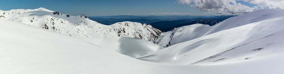
We started our ascent straight after leaving camp and climb high up onto the ridge which gave us excellent views of the Razorback Ridge on which we would spend a fair part of today. Much of the geology of this area is 1.6 billion years old and we are walking along the eroded spine of this ancient mountain range.
We had exceptional panoramic views from the quartzite ridge and it reminded us of a desert version of the Kepler track in New Zealand. We then clambered down a gully to reach the botanically rich Spencer Gorge. Lots of cycads, native mint bush, black Teatree and native pines.

Sue ridge walking
Following a wide dry sandy river bed with River Red gums we reached Birthday Waterhole and our campsite for the night. Here we met Jill and Rob from Canberra. Jill had started the Larapinta in Alice Springs and had walked to Mount Sonder and was on her way back to Alice. When asked why she would do that she said she didn’t want to pay for the transport to drop her off! They were also travelling at a very fast pace, nine days each way for the 223 km! Her joints were very sore, she said she had lost a lot of weight and she was very envious of our camp chairs!
We also met a French couple who were cycling and walking in the area. They had cycled from Adelaide to Alice springs over the past three months. They had three weeks worth of food on their bikes and don’t use food drops. By comparison we felt like we were really taking it easy!
In the evening we prepared for an early start and worked out how we could carry extra water as we were planning to camp on Brinkley Bluff tomorrow night where there was no water source. We saw a small 2.5cm light coloured frog near our camp.
Day 7: Saturday 29/8/15 Birthday Waterhole – Brinkley Bluff
Max elevation: 1207 m
Total climbing: 661 m
Total descent: -137 m
Average speed: 3.46 km/h
Total time: 04:36:28
We awoke at 5:30am with the aim of an early start to beat the heat. It was a crisp clear morning and the stars offered an impressive display. We saw Jupiter rising which was very bright in the dark sky. Steve saw a pair of Pelicans flying out of Birthday Waterhole in the early morning. Despite waking so early Jill and Rob were on the trail before us. It seems we are the slowest pair on the trail!
We were happy to be walking by 7:30am and it was a beautiful cool morning. It meant we did some of the ascent of Brinkley Bluff in the shade which helped to conserve our water use. We carried about nine litres of water up and we were really feeling the weight on the steep stretches of the track. The trail was fairly flat until the last two kilometres when it went pretty much straight up. We were very pleased to reach the summit of Brinkley Bluff in just over four hours. It was even better to speak to Paul and Beth for the first time in nearly a week. We had the full afternoon and evening to enjoy this magical place.
We had planned to spend the afternoon drinking piña coladas but unfortunately the bar was closed. I settled for a coffee bag with specks of undissolved powered milk.
We were the only ones camped on Brinkley Bluff for the cool clear night. At sunset we were treated to a full moon rising. It was hard to know where to point our cameras with our incredible 360 degree views. We could also see a bush fire burning to our north west and the lights of Alice Springs.

Moonrise from Brinkley Bluff
Max elevation: 1201 m
Total climbing: 253 m
Total descent: -694 m
Average speed: 3.86 km/h
Total time: 03:30:41

Moonset (the next morning) from Brinkley Bluff
It was a windy night on top of Brinkley Bluff and we again awoke early to try to beat the heat on the way down. We enjoyed sunrise and moon set from our prime vantage point.
It was a very scenic walk out with more ridge top walking under clear blue skies. Sue carried out a pair of bloomers someone had left of top of Brinkley Bluff but overall there was little rubbish on the trail. We set a good pace completing the 10km walk in less than four hours. We were keen to get to Standley Chasm by midday to see the gorge in the best light. We were a little concerned about the crowds as apparently bus loads arrive around the middle of the day. It was rather weird to reach the road and hear cars and lots of noise for the first time in a week.
The chasm was impressive under the noon sun and with only a few people around we were able to enjoy it in relative peace. After a short time they all left and we had it to ourselves!
We went back to the kiosk for lunch and found a man locked in his tour bus as the other tourists and the bus driver went for a walk to the chasm. We felt bad that we weren’t able to assist him but we asked some other walkers going up the chasm if they could let the bus driver know about him and one member of the group was actually a bus driver so he was soon released.
Luckily our transport arrived an hour early and we were ready to go so we set off for Alice. It really was a fantastic walk, lots of variety, interesting flora and fauna with a sense of remoteness and peace. It truly is a special part of the world.
Clickable icons on a world map which open the related trip report
A detailed, searchable trip list with links to reports, photo galleries and other content
![]()