
10/06/2015 – 14/06/2015 Kanangra Walls – Narrow Neck
Kanangra Boyd National Park, NSW
Dharug country
Participants: Stephen Davies (Leader, Photos), Sue Davies (Report), Stephen Day, Dave Whitelaw
Tuesday night was spent at the Boyd River campground to allow us to get an early start. Steve was dropped off at the Kanangra Walls Lookout where he was aiming to get an overnight star trail series. By just before dark he had managed to pitch his tent precariously, without pegs on a rock ledge near the cliff edge. Trish had driven up with us and stayed Tuesday night to drive our car back to Katoomba, all so we could avoid the long car drop after the walk – thanks heaps Trish!
Distance: 58km Total Ascent: 2900m Total Descent: 2900m Time: 26 hours
Day 1: Wednesday 10/06/2015 Kanangra Walls – Dex Creek
Morning
Max elevation: 1172 m
Total climbing: 529 m
Total descent: -395 m
Average speed: 2.72 km/h
Total time: 03:20:23
Afternoon
Max elevation: 1098 m
Total climbing: 198 m
Total descent: -311 m
Average speed: 3.55 km/h
Total time: 03:25:53

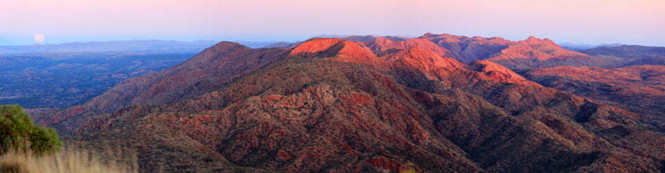
The view from Kanangra Walls Lookout
We had returned to the lookout by 8.30am in the morning, found Steve and organised to start our plateau walk across Seymour, Maxwell and Brennan Tops. The views across Kanangra Creek at the start were impressive with it’s dramatic sandstone cliffs and waterfalls.

Stephen Day on Maxwell Top
Unfortunately the views didn’t last long as we were soon enveloped in a thick fog which lasted for the rest of the day. This was a shame as it would have been a stunning ridge top walk.
Our morning took us past Crafts Wall and over Mount Berry before crossing Mount High and Mighty and Mount Stormbreaker. We then plodded over Rip, Rack, Roar and Rumble Knolls before reaching Mount Cloudmaker (which lived up to its reputation). The temperature was chilly the whole day and our breaks were very short as we cooled down very quickly.
We reached camp at Dex Creek at the estimated time of arrival, 4:20pm and quickly organised our camp and collected some firewood.
Day 2 – Thursday 11/06/2015 Dex Creek – Kanangra Creek
Max elevation: 1037 m
Total climbing: 212 m
Total descent: -1026 m
Average speed: 2.76 km/h
Total time: 05:02:58
The fog had lifted by morning to an overcast day with glimpses of blue sky. We took an early detour for views to the top of Mount Moorilla Maroo. As we progressed we had great views back to Kanangra Walls and Kings Tableland.
Our descend from Mount Strongleg along Strongleg Ridge was detailed in Dave’s guidebook as quite treacherous and taking four hours. So after selecting walking sticks from the bush to assist with the descent we proceeded and were pleasantly surprised to arrive at camp in only 70 minutes, well inside the guidebook’s time. We celebrated with a relaxed afternoon at the pleasant grassy campsite next to Kanangra Creek. Sue managed to start the campfire yet again with just one match.
Day 3 – Friday 12/06/2015 Kanangra Creek – Mobbs Swamp
Max elevation: 802 m
Total climbing: 844 m
Total descent: -272 m
Average speed: 2.91 km/h
Total time: 05:43:42
After a mild night and leisurely breakfast we headed off again. We crossed Kanangra Creek (twice) and then Coxs River in quick succession before starting the climb up Yellow Pup Ridge. It was a long, gradual haul taking two hours to reach the summit of Mount Yellow Dog.

Dave and Sue crossing Coxs River
Steve Day deserves an honourable mention for picking up a discarded pair of preloved joggers located near a wombat hole and carrying them out. We wondered if he may have been depriving the wombat of his prized possession to attract the fairer sex.

Sue amongst the grass plants
After lunching on Mount Yellow Dog we walked over the undulating terrain of Yellow Dog Ridge, along the way passing impressive casuarina and grass plant forests. We decided we had had enough by the time we reached camp at Mobbs Swamp and were very glad we had not walked the full day from Dex Creek as recommended in our guidebook. A group of high school students doing their Duke of Edinburgh awards and their teachers joined us in the late afternoon but thankfully camped a reasonable distance away.
Day 4 – Saturday 13/06/2015 Mobbs Swamp – Splendour Rock return
Max elevation: 948 m
Total climbing: 376 m
Total descent: -360 m
Average speed: 2.90 km/h
Total time: 04:59:28
Today was a scheduled “look around and take it easy day”. We completed a circuit from camp taking in Splendour Rock and some of the Wild Dog Mountains.
The views from Splendour Rock on Mount Dingo were impressive. There was mist in the valleys, we could see Lake Burragorang (behind Warragamba Dam) and Kanangra Walls looked a long way away. At Splendour Rock we spent some time checking out the Remembrance Plaque and log book dedicated to fallen soldiers who were bushwalkers. A serene and thought provoking place were bushwalkers conduct Anzac Day ceremonies.

Sue, Dave and Steve climbing Splendour Rock
We continued through Dingo Gap and onto Mount Merrimerrigal where we found a fantastic spot to have lunch, absorbing the warm sunshine and taking in the glorious views. It was hard to leave but a cuppa was calling back at camp. The climb down was moderately steep and mostly off track. We arrived back at camp in time for arvo tea and R&R in the dappled afternoon sunshine.
Bizarrely, around 6:00pm, three headlamps pierced the darkness as three walkers entered camp. They were doing the K to K in one day, having starting at 7:00am that morning. They still had about two hours of walking in the dark to go. Each to his own!
Day 5 – Sunday 14/6/15 Splendour Rock – Narrow Neck
Max elevation: 1084 m
Total climbing: 785 m
Total descent: -493 m
Average speed: 4.58 km/h
Total time: 05:38:17
We got off to an early start today, all packed and ready to go by 8.30am. It was a beautiful crisp, clear morning. Dave also deserves an honourable mention for carrying out a discarded garbage bag left in a tree hollow amongst a pile of toilet paper. It really makes you wonder about some people!
We made good time to reach Medlow Gap and then Tarros Ladder on Narrow Neck within a couple of hours, first walking through fog before climbing above it to glorious views.
Tarros Ladder got the hearts pumping, especially when lugging a heavy pack while clambering up, the at times oddly positioned handles and pegs.

Dave climbing Tarros Ladder
From the top we enjoyed the expansive views with fog still hanging around in the valleys. From here there was a 9.5km fire trail slog. The track was undulating and there were quite a few cyclists out enjoying the pleasant sunny day on the Narrow Neck firetrail. A family from Glenwood stopped the chat to us on their way out. This was to our advantage as they arrived back at the car park at the same time as us and they were kind enough to give Steve a lift back to our car in Katoomba. We were enjoying a cappuccino and cake by 3.00pm.

Ruined Castle and Mount Solitary from Narrow Neck
We enjoyed five days of pleasant weather, great camping and campfires, lots of laughs and good company. Also notable were the very melodic sounds of the almost ever present lyrebirds and bell birds. We were glad we had walked the track over five days to really savour it.
Clickable icons on a world map which open the related trip report
A detailed, searchable trip list with links to reports, photo galleries and other content
![]()
A truly wonderful walk, enjoyed every bit of it. Thanks to the Davies’ & Dave , also the wonderful Trish for logistics & fireside support, and scones.